Munster, Western Australia

Last updated

Munster
Perth,  Western Australia
Cockburn Cement Munster seen from Lake Coogee, July 2021 02.jpg
Cockburn Cement, Munster
Munster, Western Australia
Coordinates 32°08′31″S115°47′53″E / 32.142°S 115.798°E / -32.142; 115.798
Population199 (SAL 2021) [1]
Postcode(s) 6166
Area4.4 km2 (1.7 sq mi) [2]
Location28 km (17 mi) SW of Perth
LGA(s) City of Cockburn
State electorate(s) Cockburn
Federal division(s) Fremantle
Suburbs around Munster:
Lake Coogee Beeliar Beeliar
Henderson Munster Beeliar
Henderson Henderson Wattleup

Munster is a suburb of Perth, Western Australia, located within the City of Cockburn.

Contents

History

The suburb was named in 1954 from the original name of Lake Coogee , being Lake Munster, which was named after Prince William, Earl of Munster, and later King William IV. The district had been known as South Coogee since the 1870s and this earlier name remains in use by older settlers of the area. The district contains the site of Thomas Peel's original settlement, the Clarence townsite, the first recorded land grants in the Cockburn area, and around Lake Coogee the remains of the cottages built by the Pensioner Guards in the 1880s. The Munster district is unique in the continuous occupation of the Anderson, Newman, and Sawle properties by those families since the last century.[ timeframe? ]

In 1895 a postal directory mentioned that the suburb of Lake Munster was "also known as Coogee". In later years this name was applied more to the area north-west of the lake, while the rest of the area became known for postal purposes as Woodman Point and South Coogee in the 1950s. Munster was officially adopted as a suburb name in 1954. [3]

In 2019, the City of Cockburn approved a split of Munster, whereby the north-western part of the suburb became the new suburb of Lake Coogee while another part, in the south-west, was added to the suburb of Henderson. Only the eastern part of Munster remained part of the existing suburb. The changes came into effect on 30 March 2020. [4] [5] [6]

Geography

The suburb is bounded by Fancote Avenue to the north, Lorimer and Henderson Roads to the east, Russell Road to the south and Rockingham Road to the west. [7]

The suburb contains the Cockburn Cement works, [8] which has a significant impact on the surrounding land use (restricting the residential growth of the area). The Australian Marine Complex [9] was, until 2020, also partially located within the southern portion of the suburb, primarily the Technology Precinct (which includes Raytheon Australia, and a new TAFE facility - Australian Centre for Energy and Process Training (ACEPT) - South Metropolitan TAFE).

Transport

Bus

Related Research Articles

<span class="mw-page-title-main">City of Cockburn</span> Local government area in Western Australia

The City of Cockburn is a local government area in the southern suburbs of the Western Australian capital city of Perth about 8 kilometres (5 mi) south of Fremantle and about 24 kilometres (15 mi) south of Perth's central business district. The City covers an area of 167.5 square kilometres (64.7 sq mi) and had a population of over 104,000 as at the 2016 Census.

<span class="mw-page-title-main">Coolbellup, Western Australia</span> Suburb of Perth, Western Australia

Coolbellup is a suburb in Perth, Western Australia, located 15 kilometres (9.3 mi) south of the central business district within the local government area of the City of Cockburn.

<span class="mw-page-title-main">Division of Fremantle</span> Australian federal electoral division

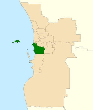
The Division of Fremantle is an electoral division of the Australian House of Representatives in Western Australia.

<span class="mw-page-title-main">Leeming, Western Australia</span> Suburb of Perth, Western Australia

Leeming is a southern suburb of Perth, Western Australia. It is divided between the three local government areas of the City of Melville, the City of Cockburn (south) and the City of Canning (north-east). It is located approximately 17 kilometres (11 mi) south of the Perth central business district and 13 kilometres (8.1 mi) east of Fremantle.

<span class="mw-page-title-main">Canning Vale, Western Australia</span> Suburb of Perth, Western Australia

Canning Vale is a southern suburb of Perth, 22 km (13.7 mi) from the central business district. Its local government areas are the City of Canning and the City of Gosnells.

<span class="mw-page-title-main">Kwinana Beach, Western Australia</span> Suburb of Perth, Western Australia

Kwinana Beach is an outer southwestern suburb of Perth, Western Australia, located within the City of Kwinana. It is one of the traditional industrial suburbs in the Perth metropolitan region.

<span class="mw-page-title-main">Naval Base, Western Australia</span> Suburb of Perth, Western Australia

Naval Base is an coastal southwestern suburb of Perth, Western Australia, located within the City of Kwinana. It is a traditional industrial suburb in the Perth metropolitan region and contains a significant amount of heavy industry. It is named after the proposed and partially built Henderson Naval Base.

<span class="mw-page-title-main">Beeliar, Western Australia</span> Suburb of Perth, Western Australia

Beeliar is a suburb of Perth, Western Australia, located within the City of Cockburn. The name refers to the Beeliar people, a group of Aboriginal Australians who had land rights over the southern half of Perth's metropolitan area. The suburb contains the Thomsons Lake Nature Reserve.

<span class="mw-page-title-main">Coogee, Western Australia</span> Suburb of Perth, Western Australia

Coogee is a southern coastal suburb of Perth, Western Australia, located within the City of Cockburn.

<span class="mw-page-title-main">Henderson, Western Australia</span> Suburb of Perth, Western Australia

Henderson is a suburb of Perth, Western Australia, located within the City of Cockburn.

<span class="mw-page-title-main">Spearwood, Western Australia</span> Suburb of Perth, Western Australia

Spearwood is a southern suburb of Perth, Western Australia, located within the City of Cockburn. This suburb derives its name from the Spearwood bush which is a common shrub in the area.

Wattleup is a southern suburb of Perth, Western Australia, located within the City of Cockburn. In the mid 1990's to the early 2000's, planning was undertaken to redevelop the suburb as part of the Hope Valley-Wattleup Redevelopment Project, also known as "Latitude 32". This was to involve the acquisition and demolition of the townsite, and its rezoning and redevelopment for industrial use. The townsite of Wattleup was located at the western end of the suburb, at the intersection of Wattleup Road and Rockingham Road. Wattleup had many market gardens in the past. They provided agricultural produce for the town of Fremantle.

<span class="mw-page-title-main">City of Rockingham</span> Local government area in Western Australia

The City of Rockingham is a council and local government area, comprising the south coastal suburbs of the Western Australian capital city of Perth.

<span class="mw-page-title-main">Cockburn Road</span> Road in Perth, Western Australia

Cockburn Road is a major road in the southern suburbs of Perth, which connects Fremantle and Kwinana. While it is for the most part a coastal road, much of its length travels through heavy industrial areas. However, a number of other facilities can be found on the road—the Woodman Point Recreation Reserve which includes camping and accommodation facilities, the Beeliar Regional Park and the Cockburn International Raceway.

<span class="mw-page-title-main">North Coogee</span> Suburb of Perth, Western Australia

North Coogee is a coastal, western suburb of Perth, Western Australia, located within the City of Cockburn. The suburb is immediately to the north of Coogee, which takes its name from the lake, Lake Coogee, in the area, which translates to "Body of water" in the native Aboriginal Nyoongar language. Originally this lake was named Lake Munster after Prince William, the Earl of Munster, and later King William IV. The Aboriginal name Kou-gee was recorded in 1841 by Thomas Watson and has been variously spelt Koojee, Coojee and Coogee.

<span class="mw-page-title-main">Rockingham, Western Australia</span> City in Western Australia

Rockingham is a suburb of Perth, Western Australia, located 47 km south-south-west of the city centre. It acts as the primary centre for the City of Rockingham. It has a beachside location at Mangles Bay, the southern extremity of Cockburn Sound. To its north stretches the maritime and resource-industry installations of Kwinana and Henderson. Offshore to the north-west is Australia's largest naval fleet and submarine base, Garden Island, connected to the mainland by an all-weather causeway. To the west and south lies the Shoalwater Islands Marine Park.

<span class="mw-page-title-main">Kwinana freight railway</span> Freight railway in Perth, Western Australia

The Kwinana freight railway lines are a network of railways predominantly servicing the heavy industrial areas at Kwinana Beach south of Perth and to provide for the transport of freight servicing Fremantle Harbour, Kewdale Intermodal Facility and other freight destinations in Perth. While some lines were constructed in the 1900s, most of the network was constructed in the 1950s and 1960s.

<span class="mw-page-title-main">Treeby, Western Australia</span> Suburb of Perth, Western Australia

Treeby is a southern suburb of Perth, Western Australia, located within the City of Cockburn. It is located on the east side of the Kwinana Freeway, close to Cockburn Central.

<span class="mw-page-title-main">Lake Coogee, Western Australia</span> Suburb of Perth, Western Australia

Lake Coogee is a suburb of Perth, Western Australia, located within the City of Cockburn, and named after Lake Coogee, located within the suburb.

References

  1. Australian Bureau of Statistics (28 June 2022). "Munster (suburb and locality)". Australian Census 2021 QuickStats. Retrieved 28 June 2022.  OOjs UI icon edit-ltr-progressive.svg
  2. Australian Bureau of Statistics (28 June 2022). "2021 Community Profiles: Munster (State Suburb)". 2021 Census of Population and Housing. Retrieved 16 July 2022. OOjs UI icon edit-ltr-progressive.svg
  3. "History of metropolitan suburb names – M". Western Australian Land Information Authority. Archived from the original on 16 March 2022. Retrieved 28 November 2007.
  4. "New Suburb and Boundary Changes: Lake Coogee, Munster and Henderson". Comment on Cockburn. Retrieved 27 November 2019.
  5. "Locality Boundary Amendments". City of Cockburn. Retrieved 27 November 2019.
  6. Ben Smith (5 November 2019). "Suburb name change could boost property prices". Communitynews.com.au. Cockburn Gazette. Retrieved 27 November 2019.
  7. "Locality Boundary Amendments Lake Coogee / Munster / Henderson" . Retrieved 27 May 2021.
  8. Cockburn cement webpage
  9. AMC website
  10. "Route 549". Bus Timetable 125 (PDF). Transperth. 17 August 2022 [effective from 10 October 2022].

Commons-logo.svg Media related to Munster, Western Australia at Wikimedia Commons