
The City of Cockburn is a local government area in the southern suburbs of the Western Australian capital city of Perth about 8 kilometres (5 mi) south of Fremantle and about 24 kilometres (15 mi) south of Perth's central business district. The City covers an area of 167.5 square kilometres (64.7 sq mi) and had a population of over 104,000 as at the 2016 Census.

Yangebup is a southern suburb of Perth, Western Australia in the City of Cockburn. It takes its name from the nearby Yangebup Lake.

Coolbellup is a suburb in Perth, Western Australia, located 15 kilometres (9.3 mi) south of the central business district within the local government area of the City of Cockburn.

Jandakot is a southern suburb of Perth, Western Australia, located within the City of Cockburn local government area. It is best known for Jandakot Airport that is situated entirely within the suburb, the airport being "the busiest general aviation airport in Australia in terms of aircraft movements", the sixth-busiest civilian airport in Australia in the fiscal year ending 30 June 2018, and in the 2011 fiscal year even the busiest civilian airport in Australia.

Kardinya is a suburb 13 kilometres (8 mi) south-southwest of the central business district of Perth, the capital of Western Australia. It is in the City of Melville local government area. It is predominantly a low-density residential suburb consisting of single-family detached homes. There is a commercial area in the centre of the suburb, with a shopping centre and several other shops. In the northwest is a small light industrial area. Kardinya has a population of 8,730 people.

Atwell is a suburb within the metropolitan area of Perth, Western Australia, situated 21 kilometres (13 mi) south of Perth City, and located in the City of Cockburn local government area.

Beeliar is a suburb of Perth, Western Australia, located within the City of Cockburn. The name refers to the Beeliar people, a group of Aboriginal Australians who had land rights over the southern half of Perth's metropolitan area. The suburb contains the Thomsons Lake Nature Reserve.

Coogee is a southern coastal suburb of Perth, Western Australia, located within the City of Cockburn.
North Lake is a suburb located 18 kilometres (11 mi) south of the central business district of Perth, the capital of Western Australia, and 8 kilometres (5 mi) from the Indian Ocean. Named after the eponymous lake, the suburb and lake are located within the City of Cockburn local government area.

Whadjuk, alternatively Witjari, are Noongar people of the Western Australian region of the Perth bioregion of the Swan Coastal Plain.
The Beeliar Wetlands is a wetland located in the southwest portion of Western Australia. It is made up of two chains of lakes and wetlands that run parallel to the west coast of Australia. They are situated on the Swan Coastal Plain between the Darling Escarpment and the Indian Ocean. Beeliar was the name given to the area by the Aboriginal people that lived and hunted in the area.

North Coogee is a coastal, western suburb of Perth, Western Australia, located within the City of Cockburn. The suburb is immediately to the north of Coogee, which takes its name from the lake, Lake Coogee, in the area, which translates to "Body of water" in the native Aboriginal Nyoongar language. Originally this lake was named Lake Munster after Prince William, the Earl of Munster, and later King William IV. The Aboriginal name Kou-gee was recorded in 1841 by Thomas Watson and has been variously spelt Koojee, Coojee and Coogee.

Beeliar Regional Park is a conservation park approximately 19 kilometres (12 mi) south of the central business district in Perth, Western Australia, located within the Citys of Cockburn, Kwinana and Melville. The regional park is named after the indigenous Beeliar people of the area.

Bibra Lake is a freshwater lake in the suburb of Bibra Lake, located south of the central business district of Perth, the capital of Western Australia. The suburb and lake are located within the City of Cockburn local government area. It is bounded by the Roe Highway reservation to the north, Stock Road to the west, the Kwinana Freeway to the east and the freight rail line to the south.

Lake Coogee is a saline lake in the suburb of Lake Coogee, 21 kilometres (13 mi) south-west of the central business district of Perth, the capital of Western Australia. It is part of Beeliar Regional Park.

Yangebup Lake is a freshwater lake in the suburb of Yangebup, 18 kilometres (11 mi) south-west of the central business district of Perth, the capital of Western Australia. It is part of Beeliar Regional Park.

The Spectacles Wetlands is a wetland located in the eponymous suburb, 30 kilometres (19 mi) south of the central business district of Perth, the capital of Western Australia. It is part of Beeliar Regional Park.
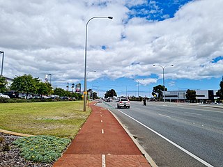
Beeliar Drive is a major arterial road in the southwestern part of the Perth Metropolitan Area. It provides an important and unbroken east-west link between Kwinana Freeway and Stock Road providing access to residential developments in Beeliar, Yangebup and Lake Coogee in the west to commercial and industrial development in Cockburn Central, Jandakot and Success in the east. It is one of Perth's more recent arterial road constructions with development of the road occurring between the early 1990s and early 2020s.

WA Wildlife, operated by Native ARC Inc, is a wildlife rescue, treatment and rehabilitation facility in the Beeliar Wetlands near Bibra Lake, Western Australia; it was the first wildlife rehabilitation facility to be licensed as a veterinary hospital by the Veterinary Practice Board of Western Australia in 2018. It has a purpose built hospital to care for the animals, with intensive care unit facilities to care for animals that would have previously been euthanised. The hospital provides treatment to more than 6500 sick and injured native animals each year. Facilities include a triage room, treatment room, consultation room, laboratory, surgery, radiology, ICU, seabird, mammal and reptile wards, isolation ward with decontamination chamber and a stand-alone necropsy suite. WA Wildlife is part of group of organisations helping to protect the nests of the snake-necked turtles that breed around Bibra Lake. In 2020 it was estimated that 25 of the hatchlings were able to make it to the safety of the lake. Native Arc Inc is a registered charity, number 21503, licensed under the Charitable Collections Act 1946.

North Lake Road is a major road in the southwestern suburbs of the Perth metropolitan area functioning as an intermediate arterial collector positioned between the limited-access Stock Road to the west and Kwinana Freeway to the east. North Lake Road's northern terminus is at Canning Highway with its southern end at Armadale Road with the Kwinana Freeway exit as of December 2021. North Lake Road was part of the old State Route 14 until the early 2010s when upgrades and extensions to the more south-westerly Spearwood Avenue and Beeliar Drive resulted in its status being revoked.


