North Coogee is a coastal, western suburb of Perth, Western Australia, located within the City of Cockburn. The suburb is immediately to the north of Coogee, which takes its name from the lake, Lake Coogee, in the area, which translates to "Body of water" in the native Aboriginal Nyoongar language. Originally this lake was named Lake Munster after Prince William, the Earl of Munster, and later King William IV. The Aboriginal name Kou-gee was recorded in 1841 by Thomas Watson and has been variously spelt Koojee, Coojee and Coogee.
North Coogee was created on 19 December 2005 and incorporated portions of the surrounding suburbs of Hamilton Hill, Spearwood and Coogee.[3][4]
Location
North Coogee is located 4 kilometres (2.5mi) south of Fremantle, and is bounded by the municipal boundary of the City of Fremantle to the north, Cockburn Road and Beeliar Regional Park to the east, Powell Road to the south and Cockburn Sound to the west.
The first development in the area may have been when Richard Goldsmith Meares who established a lime burning kiln in 1831, south of the Clarence townsite. Meares had arrived at the Swan River Colony with Thomas Peel in the previous year.[5] Meares abandoned the site after a few months moving to Mount Helena, later becoming the Government Resident at York.
As the area was adjacent to the relatively safe harbour of Owen's Anchorage in Cockburn Sound, the area began to be used as an alternative destination point for ship arrivals.
The original land grant was to George Robb and stretched between Hamilton Hill and North Lake. In 1899 it was further subdivided and by 1900 the area saw the establishment of a number of commercial lime kilns, to provide for the construction boom and population growth which had been brought about by gold discoveries.
The area continued to take on an industrialised character that continued until the early 1990s. Features of the area included the Fremantle Smelting Works, just south of Island Street, which processed lead and base bullion from Kalgoorlie. Next to the smelter was the slaughter house of Copley & Co, processing sheep and cattle on the same location where John Wellard had slaughtered sheep for the Convict establishment in the early 1850s.
Further south at Robb Jetty, slaughter houses operated by Forrest, Emanuel & Co, and Connor, Doherty and Durack existed, these slaughter houses essentially supplied all the meat to the metropolitan area and the expanding goldfields. The livestock arriving from the north-west of the state including the Kimberley Region and were unloaded from the ships onto the jetty. As there was no cold storage at the slaughter houses extensive pasturing for the animals as well as small market gardens were established in the region around the abattoir.
In 1898 a railway was built from Fremantle to Robb Jetty. The slaughter houses expanded with a bone mill, blood manure and skin-drying sheds added.
Cattle being unloaded from a ship at Robb Jetty in the 1920s. Livestock were shipped from the Kimberley.
Next to the slaughter houses an explosives magazine was built in the sandhills. In addition a piggery, slaughter house and bacon factory were built by J.C Hutton & Co, south of Robb Jetty at James Rocks.
In 1903 the railway was extended to Woodman Point and the explosives magazine was moved there, further away from Fremantle.
The area steadily became the centre of much of Perth's heavy industry and comprised the coal-fired power station, railway marshalling yards, abattoir as well as numerous skin drying sheds. From the 1980s however, pressures brought on by demands for residential housing began a process of removal of the various facilities.
The yard was decommissioned in the Westrail era in the 1990s.
Robb Jetty Abattoir
C.Y. O'Connor beach–along the shore line left to right; Robb Jetty pylons dark area below the water, bow of SSWyola, an old timber barge, in the water the C.Y. O'Connor statue.
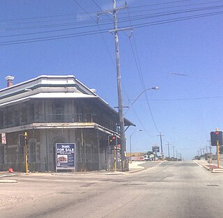
The abattoir was closed in 1994 with the jetty itself dismantled in the 1960s. All that remains of the former jetty are the pylons which extend between 200 and 300 metres (660 and 980ft) out to sea.[6] The chimney is the only remaining part of the large complex of buildings which included offices, holding yards, freezer and chiller facilities. The chimney is listed in the State Register of Heritage Places.[7]
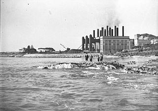
Construction of the Power Station commenced in January, 1946. The South Fremantle site was chosen for its relatively close metropolitan population, its proximity to nearby railway facilities for the delivery of coal and the ease with which seawater could be utilised for the cooling system. The four boilers 1, 2, 3 & 4 of 'A' Station were fired up in January 1951; the first 25 MW turbo-alternator came on line in May 1951 prior to the official opening of the Power Station on 27 June 1951 by the Hon. David Brand, Minister for Electricity. In September 1951, the second 25 MW turbo alternator came on line. The No. 3 turbo alternator came on line in January 1954, and the No. 4 turbo alternator in December 1954. The power station was then complete with a total capacity of 100 MW.
Much of the plant was designed and manufactured in Great Britain, with skilled contractors sent out from Britain to assemble the plant on site. The State Energy Commission encouraged the recruitment of staff by providing housing in the Hilton Park area, and the new suburb soon had many community amenities. A bus service from the Power Station to Hilton and Fremantle was provided for shift workers. Over 250 workers were employed at the power station during the 1950s.
In 1954, a major fire at South Fremantle in the coal conveyor from the crusher house caused structural damage and resulted in a switch to oil fuel for the boilers. In the mid 1970s the plant was converted back to coal, which fuelled the station until its closure in 1985. By the 1980s production of electricity at South Fremantle had become uneconomical. The interconnected grid then was supplying electricity from power stations with more up-to-date machinery and closer to the coal source at Collie, Bunbury, Kwinana and Muja.
In September 1985, the South Fremantle Power Station closed after 34 years service and its four chimney stacks were demolished.
1992–present
Looking from Port Coogee development north towards South Fremantle Powerstation and O'Connor Beach.
South Beach
In 2002 the State Government and Stockland sought to redevelop the former ANI/Bradken Foundry and surrounding land (including the former rail marshalling yards) for residential purposes. This was opposed by a local resident action group, Save South Beach, which actively campaigned against the redevelopment on issues of site contamination, diminished coastal setback, rail noise and coastal erosion impacts.[8] Despite the ongoing protests the redevelopment commenced with the first resident lots reaching the market in 2005.[9]
Port Coogee/Point Catherine
In 1992 the State Government agreed in-principle to develop a residential marina in the Coogee locality. In 1996 the State Government entered into an agreement with Port Catherine Developments Pty Ltd (PCD) to facilitate the proposed marina. The project was opposed by a resident action group, Coogee Coastal Action Coalition, concerned about the loss of beaches, potential coastal erosion, impact on local seagrass and existing site contamination issues[10] Since the signing of the agreement PCD has been taken over by Australand Property Group and work has commenced on the construction of the marina, with the first lots reaching the market in 2007.[11]
Cockburn Coast
In 2008 the State Government launched their vision for the development of the former industrial area between South Beach and the Port Coogee marina, with 95 hectares (230 acres) of coastal land being proposed to be redeveloped for residential purposes, housing approximately 10,000 people.[12]
The City of Cockburn is a local government area in the southern suburbs of the Western Australian capital city of Perth about 8 kilometres (5 mi) south of Fremantle and about 24 kilometres (15 mi) south of Perth's central business district. The City covers an area of 167.5 square kilometres (64.7 sq mi) and had a population of over 104,000 as at the 2016 Census.
The City of Kwinana is a local government area of Western Australia. It covers an area of approximately 118 square kilometres in metropolitan Perth, and lies about 38 km south of Perth central business district, via the Kwinana Freeway. Kwinana maintains 287 km of roads and had a population of almost 39,000 as at the 2016 Census.
The Fremantle line is a suburban railway and service in Western Australia that connects the central business district (CBD) of Perth with Fremantle.
Kwinana Beach is an outer southwestern suburb of Perth, Western Australia, located within the City of Kwinana. It is one of the traditional industrial suburbs in the Perth metropolitan region.
Coogee is a southern coastal suburb of Perth, Western Australia, located within the City of Cockburn.
Hamilton Hill is a suburb of Perth, the capital city of Western Australia, located 23 kilometres (14 mi) southwest the central business district. Its local government area is the City of Cockburn.
South Fremantle is a suburb of Perth, Western Australia, located within the City of Fremantle.
Woodman Point is a headland on the west coast of Western Australia. It is located in the Perth suburb of Coogee, 22 km (14 mi) south-south-west of the city centre and 8 km (5.0 mi) south of Fremantle. It extends westward into the Indian Ocean. The coastal waters immediately to the north of the point are known as Owen Anchorage, while to the south is Jervoise Bay. Woodman Point marks the northern extent of Cockburn Sound.
Cockburn Road is a major road in the southern suburbs of Perth, which connects Fremantle and Kwinana. While it is for the most part a coastal road, much of its length travels through heavy industrial areas. However, a number of other facilities can be found on the road—the Woodman Point Recreation Reserve which includes camping and accommodation facilities, the Beeliar Regional Park and the Cockburn International Raceway.
Bunnerong Power Station was a coal-fired power station in the south-eastern Sydney suburb of Matraville, New South Wales, Australia that was decommissioned by 1975 and subsequently demolished. When the last generating units were commissioned, it was the largest power station in the southern hemisphere, with a capacity of 375 megawatts (MW) from eleven turbo-alternators. It was able to supply up to one third of the state's electricity needs at the time. It remained the most powerful until the completion of Vales Point Power Station in 1966.
South Beach railway station was a railway station on the Transperth network. It was located on the Fremantle line, 22 kilometres from Perth station in South Fremantle.
Robbs Jetty railway station was a railway station, south of Fremantle between 1902 and 1972.
Fremantle Harbour is Western Australia's largest and busiest general cargo port and an important historical site. The inner harbour handles a large volume of sea containers, vehicle imports and livestock exports, cruise shipping and naval visits, and operates 24 hours a day. It is located adjacent to the city of Fremantle, in the Perth metropolitan region.
Woolwich Power Station was a coal-fired power station on the south bank of the Thames at Woolwich.
Stepney Power Station was a small coal-fired power station situated by the Thames on the north side of Narrow Street, Limehouse, London.
Rockingham is a suburb of Perth, Western Australia, located 47 km south-south-west of the city centre. It acts as the primary centre for the City of Rockingham. It has a beachside location at Mangles Bay, the southern extremity of Cockburn Sound. To its north stretches the maritime and resource-industry installations of Kwinana and Henderson. Offshore to the north-west is Australia's largest naval fleet and submarine base, Garden Island, connected to the mainland by an all-weather causeway. To the west and south lies the Shoalwater Islands Marine Park.
The Kwinana freight railway lines are a network of railways predominantly servicing the heavy industrial areas at Kwinana Beach south of Perth and to provide for the transport of freight servicing Fremantle Harbour, Kewdale Intermodal Facility and other freight destinations in Perth. While some lines were constructed in the 1900s, most of the network was constructed in the 1950s and 1960s.
Robbs Jetty Abattoir was an operation that was part of the Western Australia government meat export industry between 1921 and 1994. It was located in South Fremantle and it utilised the transport services provided by the Robbs Jetty railway station.
The South Fremantle Power Station is a former oil- and coal-fired power station located in North Coogee, Western Australia. The now disused building is listed on the Western Australian State Register of Heritage Places. The building is of Art Deco industrial design. It was the first major power generating equipment in Western Australia designed to operate on 50 Hz.
This page is based on this Wikipedia article Text is available under the CC BY-SA 4.0 license; additional terms may apply. Images, videos and audio are available under their respective licenses.