
The United Kingdom straddles the higher mid-latitudes between 49° and 61°N on the western seaboard of Europe. Since the UK is always in or close to the path of the polar front jet stream, frequent changes in pressure and unsettled weather are typical. Many types of weather can be experienced in a single day. In general the climate of the UK is changeable, often cloudy especially in the more northerly areas of the country, with rain evenly distributed throughout the year.
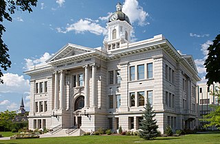
Missoula County is located in the State of Montana. As of the 2020 census, the population was 117,922, making it Montana's third-most populous county. Its county seat and largest city is Missoula. The county was founded in 1860.

Walden is the Statutory Town that is the county seat, the most populous community, and the only incorporated municipality in Jackson County, Colorado, United States. It is situated in the center of a large open valley called North Park. People from Walden and the surrounding area refer to themselves as "North Parkers". The town population was 606 at the 2020 census. The town sits at an elevation of 8,099 feet. It was established in 1889 and was incorporated 2 December 1890. Mark A. Walden, an early postmaster, gave the community his name.
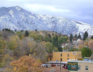
Lava Hot Springs is a city along the Portneuf River in eastern Bannock County, Idaho, United States. It is part of the Pocatello, Idaho metropolitan area. The population was 407 at the 2010 census, down from 521 in 2000. Located in the mountainous valley of the Portneuf River on the old route of the Oregon Trail and California Trail, the city has become a popular resort location, noted for its numerous hot springs amenable to bathing and a turbulent inner tube run through part of the town.
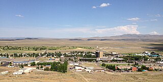
Jackpot is an unincorporated community and census-designated place (CDP) in Elko County, Nevada, United States. The population was 855 as of the 2020 census. Located less than one mile (1.6 km) from the Idaho border on US 93, Jackpot has been a popular casino gaming destination for residents of Idaho and other neighboring states since its founding.
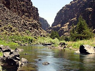
The Bruneau River is a 153-mile-long (246 km) tributary of the Snake River, in the U.S. states of Idaho and Nevada. It runs through a narrow canyon cut into ancient lava flows in southwestern Idaho. The Bruneau Canyon, which is up to 1,200 feet (370 m) deep and 40 miles (64 km) long, features rapids and hot springs, making it a popular whitewater trip.

Jarbidge is an unincorporated community in Elko County, Nevada, United States. Located at the bottom of the Jarbidge River's canyon near the north end of the Jarbidge Mountains, it lies within the Jarbidge Ranger District of the Humboldt-Toiyabe National Forest and is near the northwest edge of the Jarbidge Wilderness, approximately 10 miles (16 km) south of the Idaho–Nevada border.

The Alvord Desert is a desert located in Harney County, in southeastern Oregon in the Western United States. It is roughly southeast of Steens Mountain. The Alvord Desert is a 12-by-7-mile dry lake bed and averages 7 inches (180 mm) of rain a year. Two mountain ranges separate it from the Pacific Ocean—the Coast Range, and the Cascade Mountains. Along with Steens Mountain, these topographical features create a rain shadow. The Alvord Desert lies at an elevation of approximately 4,000 feet (1,200 m).

The climate of Chicago is classified as hot-summer humid continental with hot humid summers and cold, occasionally snowy winters. All four seasons are distinctly represented: Winters are cold and often see snow with below 0 Celsius temperatures and windchills, while summers are warm and humid with temperatures being hotter inland, spring and fall bring bouts of both cool and warm weather and fairly sunny skies. Annual precipitation in Chicago is moderate and relatively evenly distributed, the driest months being January and February and the wettest July and August. Chicago's weather is influenced during all four seasons by the nearby presence of Lake Michigan.

Picabo is an unincorporated community in Blaine County, Idaho, United States.

The Jarbidge River is a 51.8-mile-long (83.4 km), high elevation river in Elko County, Nevada and Owyhee County, Idaho in the United States. The Jarbidge originates as two main forks in the Jarbidge Mountains of northeastern Nevada and then flows through basalt and rhyolite canyons on the high plateau of the Owyhee Desert before joining the Bruneau River.
Columbus, Ohio has a humid continental climate, characterized by humid, hot summers and cold winters, with no dry season. The Dfa climate has average temperatures above 22 °C during the warmest months, with at least four months averaging above 10 °C, and below 0 °C during the coldest. The climate is transitional with the Cfa humid subtropical climate to the south, characterized by humid, hot summers and cool winters.

The Murphy Complex Fire was a 2007 wildfire that included acreage upon the Bureau of Land Management (BLM) Bruneau and Jarbidge Field Offices of Idaho, BLM Elko Field Office of Nevada, and Forest Service Mountain City and Jarbidge Districts of Nevada. It burned an estimated 652,016 acres (263,862 ha) of land. By acreage, it was the third largest wildfire in the United States between 1997 and 2009. The fire affected Owyhee and Twin Falls counties in Idaho, and Elko County, Nevada. Nearly three times as much acreage burned in the two Idaho counties as burned in Nevada. Aerial crews were primarily responsible for fighting the fire in Castleford, Idaho. About 560 wildfire firefighters were involved including a Type 1 team that specializes in fighting large wildfires. This was the third large fire in as many years on land managed by the Jarbidge Field Office in Idaho's Twin Falls District. Because of this, the BLM held a workshop on large wildfires in the district on May 12–14, 2009.
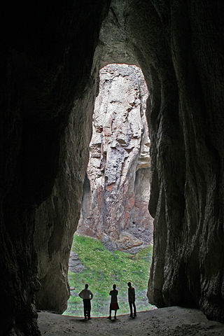
The Bruneau – Jarbidge Rivers Wilderness is located on the high basalt plateaus of Owyhee County in southwestern Idaho in the western United States. The wilderness area is named after and protects much of the Bruneau and Jarbidge Rivers and their canyons. Whitewater rafting is a popular recreational activity in this wilderness area, which has rivers up to Class V. About 40 miles (64 km) of the Bruneau River and about 28.8 miles (46.3 km) of the Jarbidge River are classified as a wild river.

Birkenfeld is an unincorporated community in Columbia County, Oregon, United States, in the Nehalem Valley on Oregon Route 202 between Jewell and Mist.
Fenn is an unincorporated community in Idaho County, Idaho, United States. It is located on U.S. Route 95 on the Camas Prairie, seven miles (11 km) northwest of Grangeville and eight miles (13 km) south of Cottonwood. Fenn had a post office with ZIP code 83531.

Sheep Creek is a 63-mile (101 km) long tributary of the Bruneau River. Beginning at an elevation of 6,126 feet (1,867 m) east of Owyhee in northern Elko County, Nevada, it flows generally north into Owyhee County, Idaho and the Owyhee Desert, where it is roughly paralleled by Idaho State Highway 51. It then flows to its mouth in the Bruneau – Jarbidge Rivers Wilderness, at an elevation of 3,415 feet (1,041 m). In 2009, 25.6 miles (41.2 km) of the creek were designated as wild by the Omnibus Public Land Management Act, which also created the Bruneau – Jarbidge Rivers Wilderness.
Reynolds is an unincorporated community in Owyhee County, Idaho, United States. Reynolds is 9.8 miles (15.8 km) west of Murphy.
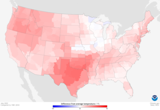
From late spring to late summer heat waves in 2022 smashed many records in North America between May and September of that year. Dozens of temperature records were surpassed in the United States.


