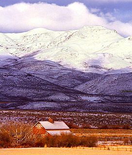
Owyhee County is a county in the southwestern corner of the U.S. state of Idaho. As of the 2010 census, the population was 11,526. The county seat is Murphy, and its largest city is Homedale. In area it is the second-largest county in Idaho, behind Idaho County.
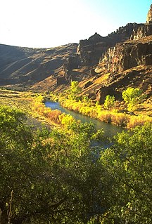
The Owyhee River is a tributary of the Snake River located in northern Nevada, southwestern Idaho and southeastern Oregon in the United States. It is 280 miles (450 km) long. The river's drainage basin is 11,049 square miles (28,620 km2) in area, one of the largest subbasins of the Columbia Basin. The mean annual discharge is 995 cubic feet per second (28.2 m3/s), with a maximum of 50,000 cu ft/s (1,400 m3/s) recorded in 1993 and a minimum of 42 cu ft/s (1.2 m3/s) in 1954.
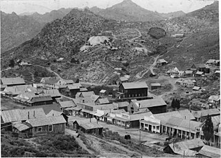
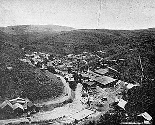
Silver City is a ghost town in northwestern Owyhee County, Idaho, United States, that is listed on the National Register of Historic Places (NRHP). At its height in the 1880s, it was a gold and silver mining town with a population of around 2,500 and approximately 75 businesses.

This is a directory of properties and districts included among the National Register of Historic Places listings in Idaho. There are approximately 1,000 sites in Idaho listed on the National Register. Each of the state's 44 counties has at least one listing on the National Register.

Mountain City is a small census-designated place in Elko County, Nevada, United States, within the Mountain City Ranger District of the Humboldt-Toiyabe National Forest. The community is located on State Route 225, approximately 16 miles (26 km) south of the Idaho border, is situated on the Owyhee River at an elevation of approximately 5,620 feet (1,710 m).
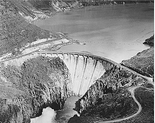
Owyhee Dam is a concrete arch-gravity dam on the Owyhee River in Eastern Oregon near Adrian, Oregon, United States. Completed in 1932 during the Great Depression, the dam generates electricity and provides irrigation water for several irrigation districts in Oregon and neighboring Idaho. At the time of completion, it was the tallest dam of its type in the world. The dam is part of the Owyhee Dam Historic District, which is listed on the National Register of Historic Places.

This is a list of the National Register of Historic Places listings in Bear Lake County, Idaho.

This is a list of the National Register of Historic Places listings in Kootenai County, Idaho.

This is a list of the National Register of Historic Places listings in Latah County, Idaho.

This is a list of the National Register of Historic Places listings in Shoshone County, Idaho.

This is a list of the National Register of Historic Places listings in Owyhee County, Idaho.
The Silver City Historic District is a historically significant mining area in northwestern Owyhee County, Idaho, United States. It includes the abandoned town of Silver City and numerous nearby towns, mines, and mining remains, covering approximately 16 square miles (41 km2). Along with Silver City, it encompasses the communities of Ruby City, Boonsville, Dewey, and Fairvlew, along with major silver mines on War Eagle Mountain and Florida Mountain.
De Lamar is a ghost town in Owyhee County, Idaho, United States. Its elevation is 5,463 ft (1,665 m), and it is approximately 6 mi (9.7 km) west of Silver City. The community lies within an area governed by the Bureau of Land Management.
Schellbourne, formerly known as Fort Schellbourne and Schell Creek Station is an ghost town located in White Pine County in Nevada, United States, located 43 miles (69 km) north of Ely. The town was a stopover along the Central Overland Route, Pony Express and original routing of the Lincoln Highway. It is today Nevada Historical Marker number 51. The site was listed on the National Register of Historic Places in 1972. Its boundaries were increased in 1977.

Reynolds is an unincorporated community in Owyhee County, Idaho, United States. Reynolds is 9.8 miles (15.8 km) west of Murphy.
Oreana is an unincorporated community in Owyhee County, Idaho, United States. Oreana is 13.7 miles (22.0 km) southeast of Murphy.

The Wickahoney Post Office and Stage Station is an abandoned post office and stagecoach station which served the community of Wickahoney, Idaho. The building was built with lava rock and featured a wooden porch and a shingled roof with seven gables. It served as Wickahoney's post office from 1895 to 1911. In addition, the building was a stagecoach stop on the route between Mountain Home, Idaho and Mountain City, Nevada. The route brought supplies to mines in northern Nevada and was considered to be Wickahoney's best chance at economic success. However, a stagecoach route through Elko, Nevada supplanted the route through Wickahoney, and the community eventually faded away. The post office building is now located in a remote desert area; while its isolation helped preserve the building long after the stagecoach route ended, it has lost its roof and porch.

The Guffey Butte–Black Butte Archeological District is a 14,000 acres (57 km2) historic district in southwestern [Idaho]], United States, that is listed on the National Register of Historic Places (NRHP). It includes numerous archeological sites in Ada, Canyon, Elmore, and Owyhee counties.

The Owyhee County Courthouse in Murphy, Idaho, is a 1-story Art Deco building designed by Tourtellotte & Hummel and constructed in 1936. The brick building features a prominent entry with fluted pilasters on either side of a square arch, with foliated sunburst panels that frame an entablature of floral, triangular, and wavelet designs. A panel above the entry reads, "Owyhee County Courthouse." The building was added to the National Register of Historic Places in 1982.


