
Interstate 82 (I-82) is an Interstate Highway in the Pacific Northwest region of the United States that travels through parts of Washington and Oregon. It runs 144 miles (232 km) from its northwestern terminus at I-90 in Ellensburg, Washington, to its southeastern terminus at I-84 in Hermiston, Oregon. The highway passes through Yakima and the Tri-Cities, and is also part of the link between Seattle and Salt Lake City, Utah. I-82 travels concurrently with U.S. Route 97 (US 97) between Ellensburg and Union Gap; US 12 from Yakima to the Tri-Cities; and US 395 from Kennewick and Umatilla, Oregon.

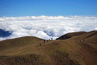
Baguio, officially the City of Baguio, is a 1st class highly urbanized city in the Cordillera Administrative Region, Philippines. It is known as the "Summer Capital of the Philippines", owing to its cool climate since the city is located approximately 4,810 feet above mean sea level, often cited as 1,540 meters in the Luzon tropical pine forests ecoregion, which also makes it conducive for the growth of mossy plants, orchids and pine trees, to which it attributes its other moniker as the "City of Pines".
Benguet, officially the Province of Benguet, is a landlocked province of the Philippines located in the southern tip of the Cordillera Administrative Region in the island of Luzon. Its capital is La Trinidad.

Itogon, officially the Municipality of Itogon,, is a 1st class municipality in the province of Benguet, Philippines. According to the 2020 census, it has a population of 61,498 people.

Tuba, officially the Municipality of Tuba,, is a 1st class municipality in the province of Benguet, Philippines. According to the 2020 census, it has a population of 48,312 people.

The Agno River, also known as the Pangasinan River, is a river on the island of Luzon in the Philippines. Traversing the provinces of Benguet, Pangasinan, and Tarlac, it is one of the largest river systems in the country, with a drainage area of 5,952 square kilometres (2,298 sq mi).

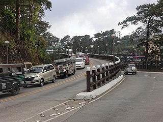
Session Road is a six-lane 1.7-kilometer (1.1 mi) major road in Baguio, Philippines. The entire road forms part of National Route 231 (N231) of the Philippine highway network.

Kennon Road, also known as the Rosario–Baguio Road, is a two lane 33.53-kilometer (20.83 mi) roadway in Benguet province in the Philippines connecting the mountain city of Baguio in Benguet to the lowland town of Rosario in La Union province. The project begun in 1903 and opened for travel on January 29, 1905. Originally called Benguet Road, it was later renamed in honor of its builder, Col. Lyman Walter Vere Kennon of the U.S. Army Corps of Engineers. It is the second oldest road that leads to Baguio, after Quirino Highway, and the shortest route to Baguio for travelers from Manila and provinces in central and southern Luzon.
The legislative districts of Benguet are the representations of the province of Benguet in the various national legislatures of the Philippines. The province is currently represented in the lower house of the Congress of the Philippines through its lone congressional district.

Mauricio "Morris" Gamsao Domogan is a Filipino lawyer and politician and is the longest serving mayor of the city of Baguio. A member of the Lakas Kampi CMD party, Domogan served three terms as mayor of Baguio, initially as acting mayor from July to October 1992, and officially as the new mayor in October 1992 after succeeding the mayoralty post from Ramon Labo after he was disqualified due to his citizenship status, until 2001, and again from 2010 to 2019.

State Route 281 (SR 281) is a short state highway in Grant County, Washington. It travels north–south for 10.5 miles (16.9 km), connecting Interstate 90 (I-90) in George to SR 28 in Quincy. The highway is a major freight corridor and also has a short spur route near George that connects it to SR 283.

U.S. Route 395 (US 395) is a United States Numbered Highway that runs from California to the inland regions of Oregon and Washington. It travels north–south through Washington, including long concurrencies with Interstate 82 (I-82) and I-90, and connects the Tri-Cities region to Spokane and the Canadian border at Laurier.

Metro Baguio, also known as BLISTT, is an agglomeration of the city of Baguio and five municipalities of the Philippine province of Benguet, namely: La Trinidad, Itogon, Sablan, Tuba, and Tublay.

The Aspiras–Palispis Highway is a Philippine major highway in northern Luzon that runs from the city of Baguio in the province of Benguet to the municipality of Agoo in the province of La Union.
The Baguio–Bua–Itogon National Road is a major highway in northern Luzon that runs from the city of Baguio to the municipality of Itogon in the province of Benguet.
The Governor Pack Road is a major highway in Baguio, Philippines, named for the American William F. Pack, who was appointed Military Governor of Benguet on November 15, 1901 and served as the civilian Governor of Mountain Province, in which Benguet was once part of as a subprovince, from 1909 to 1912.
The Loakan Road is a 6.2-kilometer (3.9 mi), major road in Baguio, Philippines. It provides access to Loakan Airport located in the outskirts of the city. The entire road forms part of National Route 231 (N231) of the Philippine highway network.
The Benguet–Nueva Vizcaya Road,, is the road system that connects the provinces of Benguet and Nueva Vizcaya in the Philippines.

The Upper Agno River Basin Resource Reserve is a protected area located on the southeast flank of the Cordillera Central in the Philippine province of Benguet along its border with Ifugao and Nueva Vizcaya. It is a resource reserve located high in the Central and Polis ranges protecting the headwaters of the Agno River. According to section 4 of the National Integrated Protected Areas System Act, a resource reserve is an extensive and relatively isolated area designated as such to preserve the natural resources of the area. The reserve comprises 77,561 hectares of the catchment area that feeds the Ambuklao and Binga dams, two of the country's oldest hydroelectric plants that supply power to the city of Baguio and entire Benguet province. Upper Agno is north of and contiguous with the Lower Agno Watershed Forest Reserve that preserves the immediate downstream of the Binga Dam where the Agno River is impounded by a third dam, the San Roque Dam, the largest in the Philippines and the main source of water, electric energy and irrigation for surrounding regions in Luzon.

The Lower Agno Watershed Forest Reserve is a Philippine protected area that straddles the Cordillera and Ilocos regions encompassing land from the provinces of Benguet and Pangasinan. Operated by the Lower Agno WFR Protected Area Management Board under the Department of Environment and Natural Resources, Lower Agno follows the Agno River corridor from the northern villages of Itogon to just north of the municipalities of San Manuel and San Nicolas. The reserve also known as the San Roque Watershed protects the mid-Agno River basin with its meandering river and short tributaries in a pine-forested mountainous terrain at the southern end of the Cordillera Central, around 30 kilometres (19 mi) southeast of Baguio. It is located in an important mining district and includes the reservoir of the San Roque Dam, the largest dam in the country and the prime source of water, hydropower and irrigation for surrounding regions in Luzon.
