Andrews Avenue

Last updated

N192 (Philippines).svg
Andrews Avenue
Nichols Road
Andrews Avenue and NAIA Expressway.jpg
Andrews Avenue, looking west near Newport City with the elevated NAIA Expressway
Route information
Maintained by Department of Public Works and Highways - South Manila District Engineering Office
Length4.3 km (2.7 mi)
Major junctions
West endN61 (Philippines).svg N61 (Roxas Boulevard) in Baclaran, Parañaque (as Airport Road)
Major intersections
East endWest Service Road at Sales Interchange, Pasay (as Sales Road) [1]
Location
Country Philippines
Major cities Parañaque and Pasay
Highway system
  • Roads in the Philippines
N191 (Philippines).svg N191 N193 (Philippines).svg N193

Andrews Avenue (formerly and still commonly known as Nichols Road) is a major east-west thoroughfare in Metro Manila, Philippines that functions as a metropolitan linkage between Pasay and Taguig. [2] It runs underneath the NAIA Expressway almost parallel to Epifanio de los Santos Avenue (EDSA) to the north connecting Roxas Boulevard and Domestic Road near Bay City with South Luzon Expressway near Newport City. It has an arterial extension continuing 3.4 kilometers (2.1 mi) northeast to 5th Avenue and McKinley Road in Bonifacio Global City known as Lawton Avenue.

Contents

Andrews Avenue also serves as the main feeder to Ninoy Aquino International Airport from the east and west and is the main access road to Newport World Resorts (formerly Resorts World Manila).

Route description

Andrews Avenue follows the old route of Nichols Road in Pasay and is split into three sections.

Sales Road section with the elevated Phase 1 of NAIA Expressway near Villamor Air Base (pictured in 2014), prior to the construction of the Phase 2 of NAIA Expressway PAFMuseumInteriorjf0606 18.JPG
Sales Road section with the elevated Phase 1 of NAIA Expressway near Villamor Air Base (pictured in 2014), prior to the construction of the Phase 2 of NAIA Expressway
Sales Road

At its eastern terminus, the route begins as Sales Road at the Sales Interchange with the South Luzon Expressway. It is a continuation of Lawton Avenue from Fort Bonifacio via the Sales Bridge and a roundabout. It runs for approximately 900 meters (3,000 ft) as it heads southwesterly across the Villamor Air Base and Villamor Golf Course toward Ninoy Aquino International Airport (NAIA) Terminal 3. This section ends with another roundabout beneath the NAIA Expressway's off-ramp just before the road makes a sharp bend to the west.

Andrews Avenue

The main section of Andrews Avenue is an eight-lane divided arterial that runs along the northern perimeter of the airport. From the roundabout across from the Philippine Air Force Aerospace Museum, the avenue continues along the southern side of Newport City, a mixed-use development facing the NAIA Terminal 3. It passes the integrated resort complex of Newport World Resorts, the Star Cruises Centre and the Shrine of St. Therese before reaching a large roundabout, which used to have a prominent "egg structure" in the middle until 2015, called Circulo del Mundo. [3] Access to the airport terminal is via this roundabout which also serves as a boundary between Newport and the older barangays of Pasay. From the former Circulo down to the intersection with Domestic Road, the avenue is lined with airline offices and maintenance facilities including Philippine Airlines, as well as a few barangays in between. The Manila Light Rail Transit facilities are also located in this intersection before the avenue becomes known as Airport Road.

Airport Road

West of Domestic Road and a small creek called Estero de Tripa de Gallina, the road enters the Baclaran area of Parañaque. The road narrows into a four-lane undivided road carrying one-way westbound traffic. The road meets its western terminus at Roxas Boulevard.

History

Andrews Avenue in Newport City area looking north, prior to the construction of the elevated NAIA Expressway, 2011 Pasay, 1300 Metro Manila, Philippines - panoramio (13).jpg
Andrews Avenue in Newport City area looking north, prior to the construction of the elevated NAIA Expressway, 2011

The avenue was formerly called Nichols Field Road, [4] later shortened to Nichols Road, after the US air base in Pasay which it served. Nichols Field, in turn, was named after Captain Henry E. Nichols, a US Navy commander of monitor ship USS Monadnock during the Philippine–American War. [5] [6] The air base was built in 1912 [7] and the road to Fort McKinley (now Fort Bonifacio) and to Dewey Boulevard (now Roxas Boulevard) was constructed shortly thereafter. The whole stretch from Dewey to Fort McKinley was named Nichols Road. [8]

At present, the Fort Bonifacio/Taguig portion is named Lawton Avenue. In Pasay, the longest portion has been renamed to Andrews Avenue, in honor of Colonel Edwin Dudley Buencamino Andrews, the first Filipino post-war Philippine Air Force Commander who perished in the crash of 'Lili Marlene', a C-47 transport plane, at Mount Makaturing in Lanao on May 18, 1947. [9]

From 2004 to 2017, the NAIA Expressway was built above most of the road's Pasay portion. The Circulo del Mundo roundabout built on the avenue was opened to motorists in 2010, featuring its centerpiece, Layag Islas (Islands in Flight), which was constructed from September 2009 to December 2010 but was eventually dismantled in November 2014 due to public backlash over its perceived wastefulness. [10]

On April 14, 2024, a sinkhole formed along Sales Road near Villamor Air Base Gate 3, forcing the temporary closure of its two innermost eastbound lanes. Initially a pothole, it expanded to approximately 3 meters (9.8 ft) in both width and depth. [11] On April 15, Maynilad Water Services reported that the sinkhole likely resulted from soil saturation due to a water leak from its secondary pipeline, with the company investigating potential external damage as the cause. [12] SMC Infrastructure also launched an investigation whether the sinkhole and the leak have compromised the integrity of the NAIA Expressway. [13] It was finally covered on April 17. [14]

Points of interest

See also

Related Research Articles

<span class="mw-page-title-main">Ninoy Aquino International Airport</span> Commercial airport serving Metro Manila, Philippines

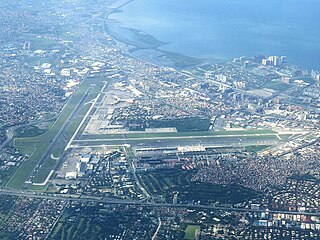
Ninoy Aquino International Airport, also known as Manila International Airport (MIA), is the main international airport serving Metro Manila in the Philippines. Located between the cities of Pasay and Parañaque, about 7 kilometers (4.3 mi) south of Manila proper and southwest of Makati, it is the main gateway for travelers to the Philippines and serves as a hub for PAL Express and Philippine Airlines. It is also the main operating base for AirSWIFT, Cebgo, Cebu Pacific, and Philippines AirAsia.

<span class="mw-page-title-main">Pasay</span> Highly urbanized city in Metro Manila, Philippines

Pasay, officially the City of Pasay, is a 1st class highly urbanized city in the National Capital Region of the Philippines. According to the 2020 census, it has a population of 440,656 people.

<span class="mw-page-title-main">EDSA</span> Limited-access circumferential highway around Metro Manila

Epifanio de los Santos Avenue, commonly referred to by its acronym EDSA, is a limited-access circumferential highway around Manila, the capital city of the Philippines. It passes through 6 of Metro Manila's 17 local government units or cities, namely, from north to south, Caloocan, Quezon City, San Juan, Mandaluyong, Makati, and Pasay.

<span class="mw-page-title-main">Villamor Air Base</span> Airbase of the Philippine Air Force

Colonel Jesus Villamor Air Base, known simply as Villamor Air Base, is the headquarters of the Philippine Air Force (PAF) and shares runways with Ninoy Aquino International Airport (NAIA). It was formerly known as Nichols Field or Nichols Air Base. Chiefly used as a PAF transport/helicopter airbase, the Maharlika Hall located at the base is used by the president of the Philippines when departing for foreign or domestic trips. Also, foreign dignitaries visiting Manila would usually arrive at the air base.

<span class="mw-page-title-main">Macapagal Boulevard</span>

Macapagal Boulevard, also known as President Diosdado Macapagal Boulevard and Macapagal Avenue, is an eight-lane road in Metro Manila, Philippines, running parallel to Roxas Boulevard from the Cultural Center of the Philippines Complex in Pasay to Asia World City in Parañaque. It was named after former Philippine President Diosdado Macapagal. This road has three major bridges, crossing the 'channels', of which the largest is the Libertad Channel, where the Libertad Water Pumping Station is situated. Thanks to intersection reconfiguring around EDSA to relieve traffic, Macapagal Boulevard is now often used to access the SM Mall of Asia to the north and Cavite to the south. It is also the main major road in Metro Manila's reclamation area called Bay City.

<span class="mw-page-title-main">Bay City, Metro Manila</span> Central Business District in Metro Manila, Philippines.

Bay City, also known as the Manila Bay Freeport Zone and Manila Bay Area, is the name for the reclamation area on Manila Bay located west of Roxas Boulevard and the Manila–Cavite Expressway in Metro Manila, the Philippines. The area is split between the cities of Manila and Pasay on the north side and Parañaque on the south.

<span class="mw-page-title-main">Radial Road 1</span> Route in Metro Manila

Radial Road 1 (R-1), informally known as the R-1 Road, is a network of roads and bridges that all together form the first arterial road of Metro Manila in the Philippines. Spanning some 42.67 kilometers (26.51 mi), it connects the cities and municipalities of Bacoor, General Trias, Imus, Kawit, Las Piñas, Manila, Naic, Noveleta, Parañaque, Pasay, and Tanza in Cavite and Metro Manila.

<span class="mw-page-title-main">Nichols station</span> Commuter rail stop in Taguig, Metro Manila

Nichols station is a railway station located on the South Main Line in Taguig, Metro Manila, Philippines, near the city's boundary with Pasay. It derives its name from one of the area's popular nicknames, Nichols, which is also the former name of Villamor Air Base. It was opened for revenue service on March 25, 2010.

<span class="mw-page-title-main">NAIA Expressway</span> Expressway in the Philippines

The Ninoy Aquino International Airport Expressway (NAIAX), signed as E6 of the Philippine expressway network, is an 12.65-kilometer (7.86 mi) elevated highway in Metro Manila, Philippines, which links the Skyway to Ninoy Aquino International Airport and Entertainment City. Traversing the cities of Pasay, and Parañaque, the NAIAX runs along Andrews Avenue, Electrical Road, and NAIA Road connecting the Skyway to Ninoy Aquino Avenue, Macapagal Boulevard, New Seaside Drive and the Manila–Cavite Expressway.

Citylink Coach Services Inc. is an intercity bus company in the Philippines operated under First Oceanic Property Management Inc., an affiliate company of Megaworld Corporation. It plies routes from Eastwood City, in Libis, Quezon City to Newport City, in Villamor Air Base, Pasay via C-5 Road, making the first bus company to traverse along the said road. This company offers shuttle services only for those who are working to the companies operated under Megaworld Corporation.

<span class="mw-page-title-main">Lawton Avenue</span> Road in the Philippines

Lawton Avenue, also known as the Fort Bonifacio–Nichols Field Road and Nichols Field Road, is the main road in Fort Bonifacio, Taguig, Metro Manila, Philippines. It follows a part of the alignment of the old Nichols route running roughly southwest to northeast from Sales Interchange to 5th Avenue and the Manila American Cemetery and Memorial. It was named after Henry Ware Lawton, a US Army general killed during the Philippine–American War.

<span class="mw-page-title-main">NAIA Road</span> Road in the Philippines

The NAIA Road, formerly known and still commonly referred to as the MIA Road, is a short 8-10 lane divided highway connecting Roxas Boulevard and the Manila–Cavite Expressway (R-1) with Ninoy Aquino International Airport (NAIA) in southwestern Metro Manila, Philippines. It is also a major local road that links the cities of Pasay and Parañaque running approximately 2.5 kilometers (1.6 mi) underneath the elevated NAIA Expressway from R-1 in Tambo, Parañaque to NAIA Terminal 2 in Pasay. En route, it intersects, from west to east, Quirino Avenue, Domestic Road, and Ninoy Aquino Avenue. The road ends at the entrance of NAIA Terminal 2.

<span class="mw-page-title-main">Domestic Road</span> Road in the Philippines

The Domestic Road, also known as the Domestic Airport Road, is a 1.171-kilometer (0.728 mi) major road in Pasay, Metro Manila, Philippines that links Andrews Avenue from the north to the NAIA Road in the south. It forms the short northwestern perimeter of Ninoy Aquino International Airport (NAIA) and its alignment is north–south running parallel to Roxas Boulevard and the NAIA Expressway located above Electrical Road to the west. It is named after NAIA Terminal 4, also known as Manila Domestic Airport, which is located along the road. Also located on this short road are the Cebu Pacific Airlines Operation Center, Airlink International Aviation School, Salem Commercial Complex and a Park N' Fly.

<span class="mw-page-title-main">Ninoy Aquino Avenue</span> Road in the Philippines located in Parañaque

Ninoy Aquino Avenue is a north–south collector road that links Pasay and Parañaque in southern Metro Manila, Philippines. It serves as an extension to Dr. Santos Avenue and as a feeder road to Ninoy Aquino International Airport (NAIA) from the south and the east. Like the airport it passes through, it is named after Senator Benigno "Ninoy" Aquino Jr., who was assassinated at the airport in 1983.

<span class="mw-page-title-main">Jose W. Diokno Boulevard</span> Major road in Bay City, Metro Manila, Philippines

Jose W. Diokno Boulevard, officially J. W. Diokno Boulevard, is a 4.38-kilometer (2.72 mi) long major collector road that runs north–south along the eastern perimeter of the SM Mall of Asia complex and parallel to Macapagal Boulevard in Bay City, Metro Manila, Philippines. It provides access from the Cultural Center of the Philippines Complex and Roxas Boulevard north to the shopping and lifestyle hub by Manila Bay in Pasay. Motorists tend to use the highway as the less congested alternative route from Manila to the Bay City vis-à-vis its parallel partner road in Macapagal Boulevard. It also connects to Entertainment City further south in Parañaque, and unlike Macapagal Boulevard is situated along the coastline overlooking Manila Bay.

<span class="mw-page-title-main">Index of Metro Manila–related articles</span>

The following is an alphabetical list of articles related to the Philippine capital region of Metro Manila.

<span class="mw-page-title-main">Sales Interchange</span> Road junction

The Sales Interchange, also known as the Nichols Interchange, is a hybrid interchange at the boundary of Pasay and Taguig in Metro Manila, the Philippines. It is composed of a lower partial cloverleaf interchange serving as the junction between the South Luzon Expressway, Sales Road, Lawton Avenue, West Service Road and East Service Road and an upper Directional T serving as the junction between the Skyway and the NAIA Expressway.

<span class="mw-page-title-main">Tambo, Parañaque</span> Barangay in Parañaque City, Metro Manila, Philippines

Tambo is an administrative division in southern Metro Manila, the Philippines. It is a coastal barangay in the city of Parañaque situated just south of Baclaran adjoining Ninoy Aquino International Airport complex to the east.

<span class="mw-page-title-main">Santo Niño, Parañaque</span> Barangay in Parañaque City, Metro Manila, Philippines

Santo Niño is an administrative division in southern Metro Manila, the Philippines. It is a barangay in the city of Parañaque immediately surrounding Ninoy Aquino International Airport on its west and south sides. A large portion of the village extends into the property of the airport grounds to include Terminal 1 as well as the western half of Runway 06/24. The village has a total land area of 245.97 hectares of which about 55% is occupied by the airport complex. Its population is concentrated in the areas along the Estero de Tripa de Gallina.

References

  1. "ROAD AND BRIDGE INFORMATION APPLICATION". Department of Public Works and Highways . Retrieved May 24, 2024.
  2. "Roads and Transport" (PDF). Pasay City Government. Archived from the original (PDF) on December 22, 2014. Retrieved October 14, 2013.
  3. "Ex-MMDA chair Bayani Fernando says "egg structure" across NAIA was built for P50 million, not P390 million". Spot.ph. Retrieved October 14, 2013.
  4. Manila American Cemetery and Memorial Archived October 16, 2013, at the Wayback Machine published by American Battle Monuments Commission; accessed October 14, 2013.
  5. Nichols Field - Ensconced in Philippine aviation history Archived March 4, 2016, at the Wayback Machine published by Lufthansa Technik Philippines; accessed October 14, 2013.
  6. Captain Henry Nichols died on the USS Monadnock in 1899 published by Ancestry.com; accessed October 14, 2013.
  7. Villamor Air Base Archived October 16, 2013, at the Wayback Machine published by the Philippine Air Force; accessed October 14, 2013.
  8. Series S501, U.S. Army Map Service, 1954- published by the University of Texas at Austin; accessed October 14, 2013.
  9. ""We serve the nation, not individuals"" . Retrieved January 6, 2024.
  10. "P50-M 'egg' near Naia 3 gone soon to ease traffic". INQUIRER.net. November 13, 2014. Retrieved May 24, 2024.
  11. Ong, Ghio (April 15, 2024). "'Sinkhole' forms along Pasay road". The Philippine Star . Retrieved April 16, 2024.
  12. Argosino, Faith (April 15, 2024). "Sinkhole along Sales Road traced to water leak; probe underway". Philippine Daily Inquirer . Retrieved April 16, 2024.
  13. Yu, Lance Spencer (April 15, 2024). "Sinkhole near Villamor Air Base causes partial closure of Sales Road in Pasay". Rappler . Retrieved April 16, 2024.
  14. "Sales Road deep hole in Pasay repaired, says MMDA". GMA Integrated News. April 17, 2024. Retrieved May 24, 2024.

14°31′25″N121°0′39″E / 14.52361°N 121.01083°E / 14.52361; 121.01083