
Makati, officially the City of Makati, is a 1st class highly urbanized city in the National Capital Region of the Philippines.

Epifanio de los Santos Avenue, commonly referred to by its acronym EDSA, is a limited-access circumferential highway around Manila, the capital city of the Philippines. It passes through 6 of Metro Manila's 17 local government units or cities, namely, from north to south, Caloocan, Quezon City, San Juan, Mandaluyong, Makati, and Pasay.

Malabon, officially the City of Malabon, is a 1st class highly urbanized city in the National Capital Region of the Philippines. According to the 2020 census, it has a population of 380,522 people.

The Metropolitan Manila Development Authority is a government agency of the Philippines responsible for constituting the regional government of Metro Manila, comprising the capital city of Manila, the cities of Quezon City, Caloocan, Pasay, Mandaluyong, Makati, Pasig, Marikina, Muntinlupa, Las Piñas, Parañaque, Valenzuela, Malabon, Taguig, Navotas and San Juan, and the municipality of Pateros.

The Pan-Philippine Highway, also known as the Maharlika Highway, is a network of roads, expressways, bridges, and ferry services that connect the islands of Luzon, Samar, Leyte, and Mindanao in the Philippines, serving as the country's principal transport backbone. Measuring 3,379.73 kilometers (2,100.07 mi) long excluding sea routes, it is the longest highway in the Philippines that forms the country's north–south backbone component of National Route 1 (N1) of the Philippine highway network. The entire highway is designated as Asian Highway 26 (AH26) of the Asian Highway Network.

The MacArthur Highway, officially the Manila North Road, is a 684.855-kilometer (425.549 mi), two-to-six lane, national primary highway and tertiary highway in Luzon, Philippines, connecting Caloocan in Metro Manila to Aparri in Cagayan. It is the second longest road in the Philippines, after Maharlika Highway. It is primarily known as MacArthur Highway in segments from Caloocan to Urdaneta, Pangasinan, although it is also applied up to Ilocos Sur, and likewise called as Manila North Road for the entire length.
Taft Avenue is a major road in the south of Metro Manila. It passes through three cities in the metropolis: Manila, Pasay, and Parañaque. The road was named after the former Governor-General of the Philippines and U.S. President, William Howard Taft; the Philippines was a former commonwealth territory of the United States in the first half of the 20th century. The avenue is a component of National Route 170 (N170), a secondary road in the Philippine highway network, and anchors R-2 of the Manila arterial road network.

Circumferential Road 4 (C-4), informally known as the C-4 Road, is a network of roads and bridges that all together form the fourth beltway of Metro Manila in the Philippines. Spanning some 28.1 kilometers (17.5 mi), it connects the cities of Caloocan, Makati, Malabon, Mandaluyong, Navotas, Pasay, Quezon City, and San Juan.

Padre Burgos Avenue, also known as Padre Burgos Street, is a 14-lane thoroughfare in Manila, Philippines.

Dr. Arcadio Santos Avenue or Dr. Santos Avenue, formerly and still referred to as Sucat Road or Parañaque–Sucat Road, is the primary east–west thoroughfare in Parañaque, southern Metro Manila, Philippines. The avenue's western end is in Barangay San Dionisio as the continuation of Ninoy Aquino Avenue. Physically, Ninoy Aquino Avenue connects northbound to NAIA Road in Pasay which, in turn, continues west to Roxas Boulevard back in Parañaque, where it ends. Its eastern end is at the East Service Road, which runs parallel to South Luzon Expressway, in Barangay Sucat, Muntinlupa, where it becomes Meralco Road to service the rest of the route to Sucat railway station.

Ninoy Aquino Avenue is a north–south collector road that links Pasay and Parañaque in southern Metro Manila, Philippines. It serves as an extension to Dr. Santos Avenue and as a feeder road to Ninoy Aquino International Airport (NAIA) from the south and the east. Like the airport it passes through, it is named after Senator Benigno "Ninoy" Aquino Jr.
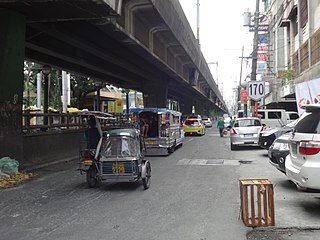
Samson Road is a major east–west street in Caloocan, northern Metro Manila, Philippines. The road is a continuation of Epifanio de los Santos Avenue (EDSA), linked to it via the Bonifacio Monument Roundabout (Monumento) to form a single through route. These roads form part of Circumferential Road 4 (C-4) of the Metro Manila's arterial road network, National Route 120 of the Philippine highway network, and Asian Highway 26 of the Asian highway network.

Blumentritt Road is a major road in Manila, Philippines. It runs through the border of the City of Manila with Quezon City from Rizal Avenue in Santa Cruz district to G. Tuazon Street in Sampaloc district. The road also forms the southern boundary of the Manila North Cemetery. It is named after Bohemian professor and filipinologist, Ferdinand Blumentritt.
Gregorio Araneta Avenue is a suburban arterial road in the Santa Mesa Heights area of Quezon City, northeastern Metro Manila, Philippines. It is a 6- to 8-lane divided avenue designated as part of Circumferential Road 3 (C-3) and physical continuation of Sergeant Rivera Street which travels from Santo Domingo Avenue at its north end near Balintawak in Quezon City, and meets N. Domingo Street in the south in San Juan near the border with Santa Mesa, Manila. En route, it intersects with Del Monte Avenue, Quezon Avenue, Eulogio Rodriguez Sr. Avenue and Magsaysay-Aurora Boulevard passing through barangays Balingasa, Manresa, Masambong, Sienna, Santo Domingo, Talayan, Tatalon, Santol, and Doña Imelda in Quezon City and Progreso in San Juan.

North Bay Boulevard is a 2.34-kilometer-long (1.45 mi) two- to four-lane access road in the Navotas Fish Port Complex of northern Metro Manila, Philippines. It is one of the main roads in Navotas which travels north-south through the southern parts of the city running parallel to Radial Road 10 (R-10) to the west. The road links the Balut area of Tondo in Manila and San Rafael Village in the south to the central Navotas barangay of Bagumbayan South in the north. It was named after its location in Manila Bay north of the Manila North Harbor complex.

The following is an alphabetical list of articles related to the Philippine capital region of Metro Manila.
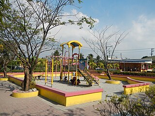
The Malabon People's Park, also known as Catmon People's Park, is an urban park situated in the densely populated village of Catmon, in the northern Metro Manila city of Malabon, the Philippines. The 0.3-hectare (0.74-acre) park occupies the central plaza of the Justice Compound, home of the Malabon Prosecutor's Office and formerly the Malabon-Navotas Regional Trial Court until 2010. It is located just off Sanciangco Street near its intersection with Governor Pascual Avenue in a flood-prone part of the city close to the south bank of the Tullahan River.

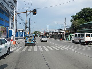
Governor Wenceslao Pascual Avenue, commonly known as simply Governor Pascual Avenue, is the principal east–west artery in the city of Malabon in Metro Manila, the Philippines. It is an unsigned route in the Philippine highway network classified by the Department of Public Works and Highways as a national tertiary road. The 4.43-kilometre (2.75 mi) two-lane avenue is the longest of the city's national roads. Portions of it are prone to flooding from the Tullahan River which flows just north of the avenue in east-central Malabon.
Rizal Avenue primarily is a road in Caloocan and Manila, Philippines.
