Padre Faura Street

Last updated

Padre Faura Street
N157 (Philippines).svg
0217jfTaft Avenue Ermita Padre Faura Streetfvf 01.jpg
Padre Faura Street looking east towards Taft Avenue.
Former name(s)Observatorio Street
NamesakeFederico Faura
Length1 km (0.62 mi)
Component
highways
Location Manila
East endRomualdez Street in Paco
Major
junctions
West endAH26 (N120) sign.svg AH 26 (N120) (Roxas Boulevard) in Ermita

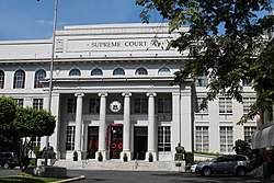
Padre Faura Street is an east-west street in downtown Manila, Philippines. It carries traffic one-way westbound from Romualdez Street to Roxas Boulevard. Starting at its eastern terminus at Paco Park in Paco district, the street heads west for a short stretch towards the intersection with Taft Avenue where the Manila Science High School is located. Past the intersection, the street traverses the district of Ermita and touches upon a number of important government institutions such as the Supreme Court and Department of Justice, as well as the Philippine General Hospital. Also located along this stretch of Padre Faura are the UP Manila College of Arts and Sciences, Robinsons Place Manila, and a number of hotels and condominiums. The street ends at the intersection with Roxas Boulevard, just across from the United States Embassy.

Contents

The street was named after the Jesuit priest Federico Faura, a Spanish director of the Manila Observatory (Observatorio Meteorológico de Manila) that was located along the street. It was formerly called Observatorio Street. [1] [2] The Manila Observatory was located at the former Ateneo Municipal campus along Padre Faura, now replaced by Robinsons Place Manila.

Points of interest

Supreme Court of the Philippines Supreme Court in Manila.JPG
Supreme Court of the Philippines

The street is the location of the Supreme Court of the Philippines Building, Department of Justice Building and the Philippine General Hospital. Near the intersection with Roxas Boulevard are several hotels and residential towers such as the 1322 Golden Empire Tower, Citystate Tower Hotel, Grand Riviera Suites, Lotus Garden Hotel Manila, Manila Astral Tower, and Robinsons Adriatico Residences. Paco Park is located on the street's eastern terminus. The Manila Science High School, Ibarra's Garden restaurant, Philippine Airlines Learning Center, and some of the buildings of the University of the Philippines Manila are also located on Padre Faura Street, such as the UP Manila College of Arts and Sciences, UP Manila Learning Resource Center and the UP Manila Oblation Statue.


Intersections

The entire route is located in Manila. 

kmmiDestinationsNotes
Romualdez StreetEastern terminus.
San Marcelino Street
Agoncillo Street
Leon Guinto Street
R-2N170 (Philippines).svg N170 (Taft Avenue)Traffic light intersection.
Maria Orosa Avenue
Santa Monica Street
Bocobo Street
Adriatico Street
Mabini StreetTraffic light intersection.
Del Pilar Street Traffic light intersection.
Guerrero Street
AH26 (N120) sign.svg AH 26 (N120) (Roxas Boulevard) R-1Western terminus. Entrance to northbound only.
1.000 mi = 1.609 km; 1.000 km = 0.621 mi

Related Research Articles

<span class="mw-page-title-main">Ermita</span> District of Manila in Metro Manila, the Philippines

Ermita is a district in Manila, Philippines. Located at the central part of the city, the district is a significant center of finance, education, culture, and commerce. Ermita serves as the civic center of the city, bearing the seat of city government and a large portion of the area's employment, business, and entertainment activities.

<span class="mw-page-title-main">Macapagal Boulevard</span>

Macapagal Boulevard, also known as President Diosdado Macapagal Boulevard and Macapagal Avenue, is an eight-lane road in Metro Manila, Philippines, running parallel to Roxas Boulevard from the Cultural Center of the Philippines Complex in Pasay to Asia World City in Parañaque. It was named after former Philippine President Diosdado Macapagal. This road has three major bridges, crossing the 'channels', of which the largest is the Libertad Channel, where the Libertad Water Pumping Station is situated. Thanks to intersection reconfiguring around EDSA to relieve traffic, Macapagal Boulevard is now often used to access the SM Mall of Asia to the north and Cavite to the south. It is also the main major road in Metro Manila's reclamation area called Bay City.

<span class="mw-page-title-main">Roxas Boulevard</span> Major street in Metro Manila, Philippines

Roxas Boulevard is a popular waterfront promenade in Metro Manila in the Philippines. The boulevard, which runs along the shores of Manila Bay, is well known for its sunsets and stretch of coconut trees. The divided roadway has become a trademark of Philippine tourism, famed for its yacht club, hotels, restaurants, commercial buildings and parks.

Robinsons Manila, also known as Robinsons Ermita and Robinsons Place Ermita, is a large shopping mall located in Ermita, Manila, Philippines. It is the largest Robinsons Mall ever built. Robinsons Manila is located beside the University of the Philippines Manila and the Philippine General Hospital, and is built at the site of the former Ateneo de Manila Campus before it moved to Loyola Heights, Quezon City. The first major expansion of the mall happened when it opened its Padre Faura Wing in June 2000. The mall was further expanded in 2006 when the nearby Midtown Hotel was demolished to make way for the construction of its Midtown Wing and the Adriatico Place Residences

1322 Golden Empire Tower is a 57-storey residential skyscraper in Manila, Philippines. It is owned by Moldex Land, Inc., part of the Moldex Group of Companies. Standing at 203 meters, it is the tallest building in the City of Manila, and is the 12th-tallest building in the country and Metro Manila as well. The building has 55 floors above ground, and 2 basement levels for parking.

The Pearl of the Orient Tower, previously known as Embassy Pointe Tower, is a residential skyscraper located in Manila, Philippines, owned by the Philippine Estates Corporation. Standing at 168 meters, it is one of the tallest buildings in the City of Manila. The building has 42 floors above ground, wherein 6 floors are for parking spaces, 5 floors for office and commercial purposes, 30 floors for luxury residential units, and 2 floors for penthouse units. There are also 4 basement levels for parking.

<span class="mw-page-title-main">Taft Avenue</span>

Taft Avenue is a major road in the south of Metro Manila. It passes through three cities in the metropolis: Manila, Pasay and Parañaque. The road was named after the former Governor-General of the Philippines and U.S. President, William Howard Taft; the Philippines was a former commonwealth territory of the United States in the first half of the 20th century. The avenue is a component of National Route 170 (N170), a secondary road in the Philippine highway network, and anchors R-2 of the Manila arterial road network.

<span class="mw-page-title-main">Padre Burgos Avenue</span>

Padre Burgos Avenue, also known as Padre Burgos Street, is a 14-lane thoroughfare in Manila, Philippines.

<span class="mw-page-title-main">Gil Puyat Avenue</span>

Senator Gil J. Puyat Avenue, also known simply as Gil Puyat Avenue and formerly and still referred to as Buendia Avenue, is a major arterial thoroughfare which travels east–west through the cities of Makati and Pasay in western Metro Manila, Philippines. It is one of the busiest avenues in Metro Manila linking the Makati Central Business District with the rest of the metropolis.

<span class="mw-page-title-main">United Nations Avenue</span> Avenue in Manila, Philippines

United Nations Avenue is a major thoroughfare in Manila, Philippines. A commercial, residential and industrial artery, the avenue runs east–west through the near-center of the city linking Ermita and Rizal Park with the eastern districts. It is home to the World Health Organization Western Pacific headquarters.

<span class="mw-page-title-main">Pablo Ocampo Street</span>

Pablo Ocampo Street, also known simply as Ocampo Street Extension and formerly and still referred to as Vito Cruz Street, is an inner city main road in Manila, Philippines. It runs west–east for about 3.448 kilometers (2.142 mi) connecting the southern districts of Malate and San Andres southeast to the adjacent city of Makati.

<span class="mw-page-title-main">Pedro Gil Street</span>

Pedro Gil Street is an east-west inner city street and a tertiary national road in south-central Manila, Philippines. It is 3.649 kilometers (2.267 mi) long and spans the entire length of Ermita, Malate, Paco and Santa Ana districts, as well as portions of San Andres and Pandacan.

<span class="mw-page-title-main">Kalaw Avenue</span>

Kalaw Avenue is a short stretch of road in the Ermita district of Manila, Philippines. It forms the southern boundary of Rizal Park running east–west from San Marcelino Street to Roxas Boulevard near the center of the city. It begins as a four-lane road at the intersection with San Marcelino widening to an eight-lane divided roadway along the stretch of Rizal Park from Taft Avenue west to Roxas Boulevard. It has a short extension into the reclaimed area of Luneta and Quirino Grandstand as South Drive. The avenue's main section between Taft Avenue and Roxas Boulevard is assigned as National Route 155 (N155) of the Philippine highway network.

<span class="mw-page-title-main">Adriatico Street</span>

Adriatico Street is a north–south road connecting Ermita and Malate districts in Manila, Philippines. Its northern terminus is at Padre Faura Street in Ermita carrying southbound traffic all the way to Quirino Avenue in Malate. South of Quirino, the street becomes two way with a wide median running down the center from just past the Manila Zoo up to its southern terminus at Pablo Ocampo Street.

<span class="mw-page-title-main">Quirino Avenue</span> Major street in Manila, Philippines

President Elpidio Quirino Avenue, more commonly known as Quirino Avenue, is a 6-10 lane divided highway in Manila, Philippines. It runs for 3.6 kilometers (2.2 mi) in a northeast–southwest direction from Nagtahan Bridge across from Santa Mesa in the north to Roxas Boulevard in Malate in the south. It passes through Paco and Pandacan districts where it also serves as a truck route between Port Area and South Luzon Expressway. North of Nagtahan Bridge, the road continues as Nagtahan Street. It is designated as part of Circumferential Road 2.

<span class="mw-page-title-main">Arnaiz Avenue</span>

Avenida Antonio Arnáiz Somoza, or simply Avenida Arnáiz, formerly known as Calle Libertad and then Calzada de Pásay, is a major east–west collector road that links Makati and Pasay in the Philippines. It stretches across western Metro Manila from Roxas Boulevard in Pasay to Epifanio de los Santos Avenue (EDSA) in Makati.

<span class="mw-page-title-main">Bonifacio Drive</span>

Bonifacio Drive is a road running for approximately 1 kilometer (0.62 mi) in a north-south direction between Intramuros and Port Area in Manila, Philippines. The boulevard is also designated as Radial Road 1 (R-1) of Manila's arterial road network, National Route 120 (N120) of the Philippine highway network and an auxiliary route of Asian Highway 26 (AH26).

<span class="mw-page-title-main">Manila High School (Intramuros)</span> Secondary public school in Philippines

The Manila High School is an educational institution in Manila, Philippines. It was first built along the present site of the Pamantasan ng Lungsod ng Maynila on General Luna Street in Intramuros from July 1963 up to April 1967. The school complex of the first Manila High School at Victoria Annex was formally inaugurated on February 26, 1967.

<span class="mw-page-title-main">Circumferential Road 1</span>

Circumferential Road 1 (C-1), informally known as the C-1 Road, is a network of roads and bridges that all together form the first and innermost beltway of Metro Manila in the Philippines. Spanning some 5.98 kilometers (3.72 mi), it connects the districts of Ermita, Intramuros, San Miguel, Quiapo, Sampaloc, Santa Cruz, Binondo, San Nicolas, and Tondo in Manila.

<span class="mw-page-title-main">Jose W. Diokno Boulevard</span> Major road in Bay City, Metro Manila, Philippines

J.W. Diokno Boulevard, which is the actual and official street name that stands for Jose W. Diokno Boulevard, is a 4.38-kilometer (2.72 mi) long major collector road that runs north–south along the eastern perimeter of the SM Mall of Asia complex and parallel to Macapagal Boulevard in Bay City, Metro Manila, Philippines. It provides access from the Cultural Center of the Philippines Complex and Roxas Boulevard north to the shopping and lifestyle hub by the Manila Bay in Pasay. Motorists tend to use the highway as the less congested alternative route from Manila to the Bay City vis-à-vis its parallel partner road in Macapagal Boulevard. It also connects to Entertainment City further south in Parañaque, and unlike Macapagal Boulevard is situated along the coastline overlooking the Manila Bay.

References

  1. Padre Faura published by the Philippine Star; accessed October 8, 2013.
  2. Of whirlwinds and waterspouts published by the Philippine Daily Inquirer; accessed October 8, 2013.

Coordinates: 14°34′43″N120°59′1″E / 14.57861°N 120.98361°E / 14.57861; 120.98361