
The NUTS codes of Greece are part of the Nomenclature of Territorial Units for Statistics, an official nomenclature of the European Commission used by Eurostat for statistical purposes.
The NUTS codes of Greece are part of the Nomenclature of Territorial Units for Statistics, an official nomenclature of the European Commission used by Eurostat for statistical purposes.
In 2011, the NUTS1 code of Greece was changed from GR to EL. GR1 was changed to EL5, GR2 to EL6, GR3 to EL3 and GR4 to EL4. [1] The change became official per European Commission regulation No. 31/2011. With regard to the transmission of data to Eurostat, the new codes entered into force by 1 January 2012. [2]
Following the Kallikratis territorial reform, the NUTS regions of Greece were redefined. With the region of Epirus being reclassified as part of Voreia Ellada ("Northern Greece", former EL1), and the region of Thessaly in exchange going to Kentriki Ellada ("Central Greece", former EL2), new NUTS1 codes have been assigned to both regions. Apart from that, a number of third-level divisions have been changed. The changes became official in December 2013 by European Commission regulation No. 1319/2013. With regard to the transmission of data to Eurostat, the new codes entered into force on 1 January 2015. [3]
The three NUTS levels are as follows:
| Level | Subdivisions | # |
|---|---|---|
| NUTS 1 | Groups of development regions | 4 |
| NUTS 2 | Regions (Perifereies) | 13 |
| NUTS 3 | Regional units or combinations thereof, sometimes equivalent to former Prefectures (Nomoi) | 52 |
Per 1 January 2015, the NUTS codes for Greece are as follows:
Below the NUTS levels, the two LAU (Local Administrative Units) levels are:
| Level | Subdivisions | # |
|---|---|---|
| LAU 1 | Municipalities (Dimoi) | 1035 |
| LAU 2 | Municipal units, municipal communities, local units | 6130 |
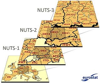
Nomenclature of Territorial Units for Statistics or NUTS is a geocode standard for referencing the administrative divisions of countries for statistical purposes. The standard, adopted in 2003, is developed and regulated by the European Union, and thus only covers the EU member states in detail. The Nomenclature of Territorial Units for Statistics is instrumental in the European Union's Structural Funds and Cohesion Fund delivery mechanisms and for locating the area where goods and services subject to European public procurement legislation are to be delivered.
In the NUTS codes of Finland (FI), the three levels are:

The Nomenclature of Territorial Units for Statistics (NUTS) is a geocode standard for referencing the administrative division of Denmark for statistical purposes. The standard is developed and regulated by the European Union. The NUTS standard is instrumental in delivering the European Union's Structural Funds. The NUTS code for Denmark is DK and a hierarchy of three levels is established by Eurostat. Below these is a further levels of geographic organisation - the local administrative unit (LAU). In Denmark, the LAU 1 are municipalities and the LAU 2 are regions.

International Territorial Level (ITL) is a geocode standard for referencing the subdivisions of the United Kingdom for statistical purposes, used by the Office for National Statistics (ONS). From 2003 and until 2020 it functioned as part of the European Union and European Statistical System's geocode standard Nomenclature of Territorial Units for Statistics or NUTS.

The Nomenclature of Territorial Units for Statistics (NUTS) is a geocode standard for referencing the subdivisions of the Czech Republic for statistical purposes. The standard is developed and regulated by the European Union. The NUTS standard is instrumental in delivering the European Union's Structural Funds. The NUTS code for the Czech Republic is CZ and a hierarchy of three levels is established by Eurostat. Below these is a further levels of geographic organisation - the local administrative unit (LAU). In the Czech Republic, the LAU 1 is districts and the LAU 2 is municipalities.

Ireland uses the Nomenclature of Territorial Units for Statistics (NUTS) geocode standard for referencing country subdivisions for statistical purposes. The standard is developed and regulated by the European Union. The NUTS standard is instrumental in delivering European Structural and Investment Funds. The NUTS code for Ireland is IE and a hierarchy of three levels is established by Eurostat. A further level of geographic organisation, the local administrative unit (LAU), in Ireland is the local electoral area.
The NUTS codes of Hungary have three levels:
The Nomenclature of Territorial Units for Statistics (NUTS) is a geocode standard for referencing the subdivisions of Bulgaria for statistical purposes. The standard is developed and regulated by the European Union. The NUTS standard is instrumental in delivering the European Union's Structural Funds. The NUTS code for Bulgaria is BG and a hierarchy of three levels is established by Eurostat. Below these is a further levels of geographic organisation - the local administrative unit (LAU). In Bulgaria, the LAU 1 is municipalities and the LAU 2 is settlements.

The Nomenclature of Territorial Units for Statistics (NUTS) is a geocode standard for referencing the subdivisions of Belgium for statistical purposes. The standard is developed and regulated by the European Union. The NUTS standard is instrumental in delivering the European Union's Structural Funds. The NUTS code for Belgium is BE and a hierarchy of three levels is established by Eurostat. Below these is a further levels of geographic organisation - the local administrative unit (LAU). In Belgium, the LAUs are municipalities.
In the NUTS codes of France (FR), the three levels are:
The Nomenclature of Territorial Units for Statistics (NUTS) is a geocode standard for referencing the subdivisions of Switzerland for statistical purposes. As a member of EFTA Switzerland is included in the NUTS standard, although the standard is developed and regulated by the European Union, an organization that Switzerland does not belong to. The NUTS standard is instrumental in delivering the European Union's Structural Funds. The NUTS code for Switzerland is CH and a hierarchy of three levels is established by Eurostat. Below these is a further levels of geographic organisation - the local administrative unit (LAU). In Switzerland, the LAUs are municipalities.
The Nomenclature of Territorial Units for Statistics (NUTS) is a geocode standard for referencing the subdivisions of Germany for statistical purposes. The standard is developed and regulated by the European Union. The NUTS standard is instrumental in delivering the European Union's Structural Funds. The NUTS code for Germany is DE and a hierarchy of three levels is established by Eurostat. Below these is a further levels of geographic organisation – the local administrative unit (LAU). In Germany the LAUs 1 is collective municipalities, and the LAU 2 is municipalities.
The Nomenclature of Territorial Units for Statistics (NUTS) is a geocode standard for referencing the subdivisions of Estonia for statistical purposes. The standard is developed and regulated by the European Union. The NUTS standard is instrumental in delivering the European Union's Structural Funds. The NUTS code for Estonia is EE and a hierarchy of three levels is established by Eurostat. Below these is a further levels of geographic organisation - the local administrative unit (LAU). In Estonia, the LAU 1 is counties and the LAU 2 are municipalities.
The three NUTS levels for Latvia (LV) are:

The Nomenclature of Territorial Units for Statistics (NUTS) is a geocode standard used for referencing the subdivisions of Cyprus for statistical purposes. The standard is developed and regulated by the European Union. The NUTS standard is instrumental in delivering the European Union's Structural Funds. The NUTS code assigned to Cyprus is CY, and Eurostat has established a hierarchical structure consisting of three levels. However, Cyprus does not have subdivisions covered by the NUTS levels, as its population is small enough to be covered within a single level.

The Nomenclature of Territorial Units for Statistics (NUTS) is developed by Eurostat, and employed in both Portugal and the entire European Union for statistical purposes. The NUTS branch extends from NUTS1, NUTS2 and NUTS3 regions, with the complementary LAU sub-categorization being used to differentiate the local areas, of trans-national importance.
In the NUTS codes of Slovenia (SI), the three levels are:
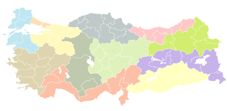
As a candidate country of the European Union, Turkey (TR) is included in the Nomenclature of Territorial Units for Statistics (NUTS). Defined in 2002 in agreement between Eurostat and the Turkish authorities, Turkey's NUTS classifications are officially termed statistical regions, as Turkey is not a member of the EU and Eurostat only defines NUTS for member states. The three NUTS levels are:

Northern Greece is used to refer to the northern parts of Greece, and can have various definitions.

International Territorial Level (ITL) is a geocode standard for referencing the subdivisions of the United Kingdom for statistical purposes, used by the Office for National Statistics (ONS). Between 2003 and 2021, as part of the European Union and European Statistical System, the geocode standard used for the United Kingdom were Nomenclature of Territorial Units for Statistics or NUTS. The NUTS code for the UK was UK and the NUTS standard had a hierarchy of three levels, with 12 first level regions, which are currently mirrored by the ITL classification, of which 9 regions are in England. The sub-structure corresponds to administrative divisions within the country. Formerly, the further NUTS divisions IV and V existed; these have now been replaced by Local Administrative Units . Between 1994 and 2011, the nine regions had an administrative role in the implementation of UK Government policy, and as the areas covered by elected bodies.