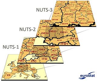
Nomenclature of Territorial Units for Statistics or NUTS is a geocode standard for referencing the administrative divisions of countries for statistical purposes. The standard, adopted in 2003, is developed and regulated by the European Union, and thus only covers the EU member states in detail. The Nomenclature of Territorial Units for Statistics is instrumental in the European Union's Structural Funds and Cohesion Fund delivery mechanisms and for locating the area where goods and services subject to European public procurement legislation are to be delivered.
In the NUTS codes of Finland (FI), the three levels are:
The Nomenclature of Territorial Units for Statistics (NUTS) is a geocode standard for referencing the administrative division of Denmark for statistical purposes. The standard is developed and regulated by the European Union. The NUTS standard is instrumental in delivering the European Union's Structural Funds. The NUTS code for Denmark is DK and a hierarchy of three levels is established by Eurostat. Below these is a further levels of geographic organisation - the local administrative unit (LAU). In Denmark, the LAU 1 are municipalities and the LAU 2 is Parishes.

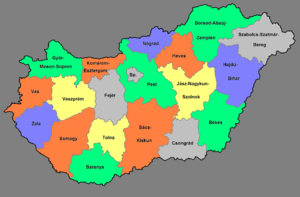
Hungary is subdivided administratively into 19 counties and the capital city (főváros) Budapest. The counties are further subdivided into 174 districts. The capital Budapest is subdivided into 23 districts.

International Territorial Level (ITL) is a geocode standard for referencing the subdivisions of the United Kingdom for statistical purposes, used by the Office for National Statistics (ONS). From 2003 and until 2020 it functioned as part of the European Union and European Statistical System's geocode standard Nomenclature of Territorial Units for Statistics or NUTS.

The Nomenclature of Territorial Units for Statistics (NUTS) is a geocode standard for referencing the subdivisions of the Czech Republic for statistical purposes. The standard is developed and regulated by the European Union. The NUTS standard is instrumental in delivering the European Union's Structural Funds. The NUTS code for the Czech Republic is CZ and a hierarchy of three levels is established by Eurostat. Below these is a further levels of geographic organisation - the local administrative unit (LAU). In the Czech Republic, the LAU 1 is districts and the LAU 2 is municipalities.

Ireland uses the Nomenclature of Territorial Units for Statistics (NUTS) geocode standard for referencing country subdivisions for statistical purposes. The standard is developed and regulated by the European Union. The NUTS standard is instrumental in delivering European Structural and Investment Funds. The NUTS code for Ireland is IE and a hierarchy of three levels is established by Eurostat. A further level of geographic organisation, the local administrative unit (LAU), in Ireland is the local electoral area.
In the NUTS codes of Italy (IT), the three levels are:

In the NUTS codes of Spain (ES), the following are the first-level political and administrative divisions.

The Nomenclature of Territorial Units for Statistics (NUTS) is a geocode standard for referencing the subdivisions of Belgium for statistical purposes. The standard is developed and regulated by the European Union. The NUTS standard is instrumental in delivering the European Union's Structural Funds. The NUTS code for Belgium is BE and a hierarchy of three levels is established by Eurostat. Below these is a further levels of geographic organisation - the local administrative unit (LAU). In Belgium, the LAUs are municipalities.
In the NUTS codes of France (FR), the three levels are:
The Nomenclature of Territorial Units for Statistics (NUTS) is a geocode standard for referencing the subdivisions of Switzerland for statistical purposes. As a member of EFTA Switzerland is included in the NUTS standard, although the standard is developed and regulated by the European Union, an organization that Switzerland does not belong to. The NUTS standard is instrumental in delivering the European Union's Structural Funds. The NUTS code for Switzerland is CH and a hierarchy of three levels is established by Eurostat. Below these is a further levels of geographic organisation - the local administrative unit (LAU). In Switzerland, the LAUs are districts (LAU-1) and municipalities (LAU-2).
As a candidate country of the European Union, Iceland (IS) is included in the Nomenclature of Territorial Units for Statistics (NUTS). The three NUTS levels are:

As a member of EFTA, Norway (NO) is not included in the Classification of Territorial Units for Statistics (NUTS), but in a similar classification used for coding statistical regions of countries that are not part of the EU but are candidate countries, potential candidates or EFTA countries. The three levels are:
The Nomenclature of Territorial Units for Statistics (NUTS) is a geocode standard for referencing the subdivisions of Estonia for statistical purposes. The standard is developed and regulated by the European Union. The NUTS standard is instrumental in delivering the European Union's Structural Funds. The NUTS code for Estonia is EE and a hierarchy of three levels is established by Eurostat. Below these is a further levels of geographic organisation - the local administrative unit (LAU). In Estonia, the LAU 1 is counties and the LAU 2 are municipalities.

The NUTS codes of Greece are part of the Nomenclature of Territorial Units for Statistics, an official nomenclature of the European Commission used by Eurostat for statistical purposes.
In the NUTS codes of Malta (MT), the three levels are:
The Nomenclature of Territorial Units for Statistics (NUTS) is a geocode standard for referencing the subdivisions of Cyprus for statistical purposes. The standard is developed and regulated by the European Union. The NUTS standard is instrumental in delivering the European Union's Structural Funds. The NUTS code for Cyprus is CY and a hierarchy of three levels is established by Eurostat. Cyprus does not have subdivisions covered by the NUTS levels, as the population is small enough to be covered in one level. Below these is a further levels of geographic organisation - the local administrative unit (LAU). In Cyprus, the LAU 1 is districts and the LAU 2 is municipalities.

The Nomenclature of Territorial Units for Statistics (NUTS) is developed by Eurostat, and employed in both Portugal and the entire European Union for statistical purposes. The NUTS branch extends from NUTS1, NUTS2 and NUTS3 regions, with the complementary LAU sub-categorization being used to differentiate the local areas, of trans-national importance.

International Territorial Level (ITL) is a geocode standard for referencing the subdivisions of the United Kingdom for statistical purposes, used by the Office for National Statistics (ONS). Between 2003 and 2021, as part of the European Union and European Statistical System, the geocode standard used for the United Kingdom were Nomenclature of Territorial Units for Statistics or NUTS. The NUTS code for the UK was UK and the NUTS standard had a hierarchy of three levels, with 12 first level regions, which are currently mirrored by the ITL classification, of which 9 regions are in England. The sub-structure corresponds to administrative divisions within the country. Formerly, the further NUTS divisions IV and V existed; these have now been replaced by Local Administrative Units . Between 1994 and 2011, the nine regions had an administrative role in the implementation of UK Government policy, and as the areas covered by elected bodies.
This page is based on this
Wikipedia article Text is available under the
CC BY-SA 4.0 license; additional terms may apply.
Images, videos and audio are available under their respective licenses.

