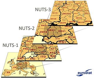
Nomenclature of Territorial Units for Statistics or NUTS is a geocode standard for referencing the administrative divisions of countries for statistical purposes. The standard, adopted in 2003, is developed and regulated by the European Union, and thus only covers the EU member states in detail. The Nomenclature of Territorial Units for Statistics is instrumental in the European Union's Structural Funds and Cohesion Fund delivery mechanisms and for locating the area where goods and services subject to European public procurement legislation are to be delivered.

The Nomenclature of Territorial Units for Statistics (NUTS) is a geocode standard for referencing the administrative division of Denmark for statistical purposes. The standard is developed and regulated by the European Union. The NUTS standard is instrumental in delivering the European Union's Structural Funds. The NUTS code for Denmark is DK and a hierarchy of three levels is established by Eurostat. Below these is a further levels of geographic organisation - the local administrative unit (LAU). In Denmark, the LAU 1 are municipalities and the LAU 2 are parishes.

The Nomenclature of Territorial Units for Statistics (NUTS) is a geocode standard for referencing the subdivisions of the Czech Republic for statistical purposes. The standard is developed and regulated by the European Union. The NUTS standard is instrumental in delivering the European Union's Structural Funds. The NUTS code for the Czech Republic is CZ and a hierarchy of three levels is established by Eurostat. Below these is a further levels of geographic organisation - the local administrative unit (LAU). In the Czech Republic, the LAU 1 is districts and the LAU 2 is municipalities.

The functions of local government in the Republic of Ireland are mostly exercised by thirty-one local authorities, termed County, City, or City and County Councils. The principal decision-making body in each of the thirty-one local authorities is composed of the members of the council, elected by universal franchise in local elections every five years from multi-seat local electoral areas using the single transferable vote. Many of the authorities' statutory functions are, however, the responsibility of ministerially appointed career officials termed Chief executives. The competencies of the city and county councils include planning, transport infrastructure, sanitary services, public safety and the provision of public libraries. Each local authority sends representatives to one of three Regional Assemblies.

The Nomenclature of Territorial Units for Statistics (NUTS) is a geocode standard for referencing the subdivisions of Bulgaria for statistical purposes. The standard is developed and regulated by the European Union. The NUTS standard is instrumental in delivering the European Union's Structural Funds. The NUTS code for Bulgaria is BG and a hierarchy of three levels is established by Eurostat. Below these are a further level of the geographic organisation - the local administrative unit (LAU). In Bulgaria, the LAU 1 is municipalities and the LAU 2 is settlements.

The Nomenclature of Territorial Units for Statistics (NUTS) is a geocode standard for referencing the subdivisions of Belgium for statistical purposes. The standard is developed and regulated by the European Union. The NUTS standard is instrumental in delivering the European Union's Structural Funds. The NUTS code for Belgium is BE and a hierarchy of three levels is established by Eurostat. Below these is a further levels of geographic organisation - the local administrative unit (LAU). In Belgium, the LAUs are municipalities.
In the NUTS codes of France (FR), the three levels are:

The Classification of Territorial Units for Statistics is a geocode standard for referencing the administrative divisions of countries for statistical purposes. The standard was developed by the European Union.
The Nomenclature of Territorial Units for Statistics (NUTS) is a geocode standard for referencing the subdivisions of Switzerland for statistical purposes. As a member of EFTA Switzerland is included in the NUTS standard, although the standard is developed and regulated by the European Union, an organization that Switzerland does not belong to. The NUTS standard is instrumental in delivering the European Union's Structural Funds. The NUTS code for Switzerland is CH and a hierarchy of three levels is established by Eurostat. Below these is a further levels of geographic organisation - the local administrative unit (LAU). In Switzerland, the LAUs are municipalities.
The Nomenclature of Territorial Units for Statistics (NUTS) is a geocode standard for referencing the subdivisions of Germany for statistical purposes. The standard is developed and regulated by the European Union. The NUTS standard is instrumental in delivering the European Union's Structural Funds. The NUTS code for Germany is DE and a hierarchy of three levels is established by Eurostat. Below these is a further levels of geographic organisation – the local administrative unit (LAU). In Germany the LAUs 1 is collective municipalities, and the LAU 2 is municipalities.
The Nomenclature of Territorial Units for Statistics (NUTS) is a geocode standard for referencing the subdivisions of Estonia for statistical purposes. The standard is developed and regulated by the European Union. The NUTS standard is instrumental in delivering the European Union's Structural Funds. The NUTS code for Estonia is EE and a hierarchy of three levels is established by Eurostat. Below these is a further levels of geographic organisation - the local administrative unit (LAU). In Estonia, the LAU 1 is counties and the LAU 2 are municipalities.

The NUTS codes of Greece are part of the Nomenclature of Territorial Units for Statistics, an official nomenclature of the European Commission used by Eurostat for statistical purposes.

The Nomenclature of Territorial Units for Statistics (NUTS) is a geocode standard used for referencing the subdivisions of Cyprus for statistical purposes. The standard is developed and regulated by the European Union. The NUTS standard is instrumental in delivering the European Union's Structural Funds. The NUTS code assigned to Cyprus is CY, and Eurostat has established a hierarchical structure consisting of three levels. However, Cyprus does not have subdivisions covered by the NUTS levels, as its population is small enough to be covered within a single level.

The Nomenclature of Territorial Units for Statistics (NUTS) is developed by Eurostat, and employed in both Portugal and the entire European Union for statistical purposes. The NUTS branch extends from NUTS1, NUTS2 and NUTS3 regions, with the complementary LAU sub-categorization being used to differentiate the local areas, of trans-national importance.
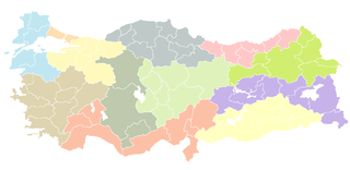
As a candidate country of the European Union, Turkey (TR) is included in the Nomenclature of Territorial Units for Statistics (NUTS). Defined in 2002 in agreement between Eurostat and the Turkish authorities, Turkey's NUTS classifications are officially termed statistical regions, as Turkey is not a member of the EU and Eurostat only defines NUTS for member states. The three NUTS levels are:

The South-East is a strategic planning area within the Southern Region in Ireland. It is a NUTS Level III statistical region of Ireland. It comprises the counties of Carlow, Kilkenny and Wexford and the city and county of Waterford. The South-East spans 7,198 km2, 10.2% of the total area of the state and according to the 2016 census had a population of 422,062.

International Territorial Level (ITL) is a geocode standard for referencing the subdivisions of the United Kingdom for statistical purposes, used by the Office for National Statistics (ONS). Between 2003 and 2021, as part of the European Union and European Statistical System, the geocode standard used for the United Kingdom were Nomenclature of Territorial Units for Statistics or NUTS. The NUTS code for the UK was UK and the NUTS standard had a hierarchy of three levels, with 12 first level regions, which are currently mirrored by the ITL classification, of which 9 regions are in England. The sub-structure corresponds to administrative divisions within the country. Formerly, the further NUTS divisions IV and V existed; these have now been replaced by Local Administrative Units . Between 1994 and 2011, the nine regions had an administrative role in the implementation of UK Government policy, and as the areas covered by elected bodies.

The Southern Region has been a region in Ireland since 1 January 2015. It is a NUTS Level II statistical region of Ireland.

The Northern and Western Region has been a region in Ireland since 1 January 2015. It is a NUTS Level II statistical region of Ireland.

The Eastern and Midland Region has been defined as a region in Ireland since 1 January 2015. It is a NUTS Level II statistical region of Ireland.
