Nanticoke, New York | |
|---|---|
 Seal | |
| Motto: "The Biggest Little Town in Broome County" | |
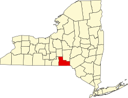
 Location in Broome County | |
 Nanticoke  Nanticoke | |
| Coordinates: 42°17′5″N76°1′29″W / 42.28472°N 76.02472°W | |
| Country | |
| State | |
| County | Broome |
| Organized | 1831 |
| Government | |
| • Type | Town Council |
| • Town Supervisor | Donald Benjamin |
| • Town Council | Members' List |
| Area | |
• Total | 24.36 sq mi (63.09 km2) |
| • Land | 24.27 sq mi (62.86 km2) |
| • Water | 0.089 sq mi (0.23 km2) |
| Elevation | 1,391 ft (424 m) |
| Population (2010) | |
• Total | 1,672 |
| 1,604 | |
| • Density | 66.1/sq mi (25.52/km2) |
| Time zone | UTC-5 (Eastern (EST)) |
| • Summer (DST) | UTC-4 (EDT) |
| ZIP Codes |
|
| FIPS code | 36-49396 |
| GNIS feature ID | 979247 |
| Website | townofnanticokeny |
Nanticoke is a town in Broome County, New York, United States. The population was 1,672 at the 2010 census. [3] The town was named after the Nanticoke people, who were a Native American tribe native to Chesapeake Bay.
Contents
The town is on the western border of the county and is northwest of Binghamton.