Triangle, New York

Last updated

Triangle, New York
Grace Episcopal Church Whitney Point NY Feb 10.jpg
Grace Episcopal Church in Whitney Point
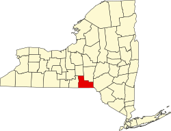
Town of Triangle NY Locator Map.png
Map highlighting Triangle's location within Broome County.
USA New York location map.svg
Red pog.svg
Triangle
Location within the state of New York
Coordinates: 42°20′57″N75°56′20″W / 42.34917°N 75.93889°W / 42.34917; -75.93889
Country United States
State New York
County Broome
Government
  Type Town Council
   Town Supervisor Stephen D. Doherty
   Town Council
Members' List
Area
[1]
  Total39.78 sq mi (103.03 km2)
  Land37.88 sq mi (98.10 km2)
  Water1.91 sq mi (4.94 km2)
Elevation
1,388 ft (423 m)
Population
 (2010)
  Total2,946
  Estimate 
(2016) [2]
2,841
  Density75.01/sq mi (28.96/km2)
Time zone UTC-5 (Eastern (EST))
  Summer (DST) UTC-4 (EDT)
FIPS code 36-007-75319
GNIS feature ID0979557

Triangle is a town in Broome County, New York, United States. The population was 2,946 at the 2010 census. [3] The town's primary settlement is the village of Whitney Point.

Contents

The town is in the northeastern part of the county and is north of Binghamton.

History

The area was first settled circa 1791. The town of Triangle was formed from the town of Lisle in 1831. The area had previously been called the "Chenango Triangle".

In 1871, the community of Whitney Point incorporated as a village within the town.

Geography

According to the United States Census Bureau, the town of Triangle has a total area of 39.8 square miles (103.0 km2), of which 37.9 square miles (98.1 km2) is land and 1.9 square miles (4.9 km2), or 4.79%, is water. [3]

The Tioughnioga River, a tributary of the Susquehanna River, flows through the southwestern part of the town.

The east town line is the border of Chenango County, and the northern town line is the border of Cortland County.

New York State Route 206 is an east-west highway in the town. New York State Route 26 is a north-south highway on the eastern side of Whitney Point Reservoir. Interstate 81 and U.S. Route 11, along with New York State Route 79, pass through the southwest corner of the town at Whitney Point.

Demographics

Historical population
CensusPop.Note
1840 1,692
1850 1,7282.1%
1860 1,693−2.0%
1870 1,94414.8%
1880 2,0736.6%
1890 1,879−9.4%
1900 1,727−8.1%
1910 1,600−7.4%
1920 1,458−8.9%
1930 1,452−0.4%
1940 1,5758.5%
1950 1,73310.0%
1960 2,01916.5%
1970 2,28513.2%
1980 2,61814.6%
1990 3,00614.8%
2000 3,0320.9%
2010 2,946−2.8%
2016 (est.)2,841 [2] −3.6%
U.S. Decennial Census [4]

As of the census [5] of 2000, there were 3,032 people, 1,131 households, and 809 families residing in the town. The population density was 79.6 inhabitants per square mile (30.7/km2). There were 1,245 housing units at an average density of 32.7 per square mile (12.6/km2). The racial makeup of the town was 97.76% White, 0.20% African American, 0.26% Native American, 0.33% Asian, 0.10% Pacific Islander, 0.26% from other races, and 1.09% from two or more races. Hispanic or Latino of any race were 0.86% of the population.

There were 1,131 households, out of which 39.6% had children under the age of 18 living with them, 56.2% were married couples living together, 10.4% had a female householder with no husband present, and 28.4% were non-families. 21.9% of all households were made up of individuals, and 8.0% had someone living alone who was 65 years of age or older. The average household size was 2.68 and the average family size was 3.14.

In the town, the population was spread out, with 29.5% under the age of 18, 7.8% from 18 to 24, 28.2% from 25 to 44, 23.1% from 45 to 64, and 11.4% who were 65 years of age or older. The median age was 36 years. For every 100 females, there were 97.5 males. For every 100 females age 18 and over, there were 94.3 males.

The median income for a household in the town was $35,982, and the median income for a family was $41,220. Males had a median income of $29,184 versus $24,792 for females. The per capita income for the town was $15,734. About 10.0% of families and 11.4% of the population were below the poverty line, including 15.3% of those under age 18 and 5.5% of those age 65 or over.

Communities and locations in Triangle

Related Research Articles

<span class="mw-page-title-main">Barker, Broome County, New York</span> Town in New York, United States

Barker is a town in Broome County, New York, United States. The population was 2,516 at the 2020 census. The town is named after John Barker, an early settler. The town is in the northern part of Broome County and is north of Binghamton.

<span class="mw-page-title-main">Chenango, New York</span> Town in New York, United States

Chenango is a town in Broome County, New York, United States. The population was 10,983 at the 2020 census.

<span class="mw-page-title-main">Fenton, New York</span> Town in New York, United States

Fenton is a town in Broome County, New York, United States. The population was 6,441 at the 2020 census. The town was named after Reuben Fenton, a governor of New York.

<span class="mw-page-title-main">Whitney Point, New York</span> Village in New York, United States

Whitney Point is a village in Broome County, New York, United States. The population was 964 at the 2010 census. It is part of the Binghamton Metropolitan Statistical Area. The name comes from Thomas and William Whitney, early developers.

<span class="mw-page-title-main">Lincklaen, New York</span> Town in New York, United States

Lincklaen is a town in Chenango County, New York, United States. The population was 396 at the 2010 census. The town was named after Colonel John Lincklaen, an agent of the Holland Land Company and a land owner. The town is in the northwestern corner of the county, northwest of the city Norwich and northeast of Cortland.

<span class="mw-page-title-main">North Norwich, New York</span> Town in New York, United States

North Norwich is a town in Chenango County, New York, United States. The population was 1,783 at the 2010 census. The town is directly north of the City of Norwich in the eastern half of the county.

<span class="mw-page-title-main">Pitcher, New York</span> Town in New York, United States

Pitcher is a town in Chenango County, New York, United States. The population was 803 at the 2010 census. The town is named after Nathaniel Pitcher, the eighth governor of New York. The town is on the western border of Chenango County, west of the city of Norwich.

<span class="mw-page-title-main">Plymouth, New York</span> Town in New York, United States

Plymouth is a town in Chenango County, New York, United States. The population was 1,804 at the 2010 census. It is an interior town in the northern part of the county. The town is northwest of the city of Norwich. Plymouth was also known as Plymouth Rock.

<span class="mw-page-title-main">Smithville, New York</span> Town in New York, United States

Smithville is a town in Chenango County, New York, United States. The population was 1,330 at the 2010 census. The town is at the western border of Chenango County, west of the city of Norwich.

<span class="mw-page-title-main">Cortlandville, New York</span> Town in New York, United States

Cortlandville is a town in Cortland County, New York, United States. The population was 8,509 at the 2010 census.

<span class="mw-page-title-main">Cuyler, New York</span> Town in New York, United States

Cuyler is a town in Cortland County, New York, United States. The population was 908 at the 2020 census.

Brookfield is a town in Madison County, New York, United States. The population was 2,403 at the 2000 census.

<span class="mw-page-title-main">Eaton, New York</span> Town in New York, United States

Eaton is a town in Madison County, New York, United States. The population was 4,284 at the 2020 census.

Lebanon is a town in Madison County, New York state, United States. The population was 1,332 at the 2010 census. The town is believed to be named after Lebanon, Connecticut.

<span class="mw-page-title-main">Sangerfield, New York</span> Town in New York, United States

Sangerfield is a town in Oneida County, New York, United States. The population was 2,561 at the 2010 census. The town is named after Jedediah Sanger, an early settler.

<span class="mw-page-title-main">Lisle, New York</span> Town in New York, United States

Lisle is a town in Broome County, New York, United States. The population was 2,751 at the 2010 census.

<span class="mw-page-title-main">New Berlin, New York</span> Town in New York, United States

New Berlin is a town in Chenango County, central New York, United States. The population was 2,682 at the 2010 census. The town contains the village of New Berlin. The town is at the eastern border of the county and is northeast of Norwich.

<span class="mw-page-title-main">Norwich (town), New York</span> Town in New York, United States

Norwich is a town in Chenango County, New York, United States. The population was 3,998 at the 2010 census.

<span class="mw-page-title-main">Smyrna, New York</span> Town in New York, United States

Smyrna is a town in Chenango County, New York, United States. The population was 1,280 at the 2010 census. Smyrna is named after a coastal city in ancient Greece, nowadays modern Izmir in Turkey.

<span class="mw-page-title-main">DeRuyter, New York</span> Town in New York, United States

DeRuyter is a town in Madison County, New York, United States. The population was 1,589 at the 2010 census. The town is named after Michiel Adriaenszoon de Ruyter, a famous admiral in the Dutch navy. The name de Ruyter means "the Rider".

References

  1. "2016 U.S. Gazetteer Files". United States Census Bureau. Retrieved July 4, 2017.
  2. 1 2 "Population and Housing Unit Estimates" . Retrieved June 9, 2017.
  3. 1 2 "Geographic Identifiers: 2010 Demographic Profile Data (G001): Triangle town, Broome County, New York". U.S. Census Bureau, American Factfinder. Archived from the original on February 12, 2020. Retrieved February 4, 2014.
  4. "Census of Population and Housing". Census.gov. Retrieved June 4, 2015.
  5. "U.S. Census website". United States Census Bureau . Retrieved January 31, 2008.

42°20′23″N75°52′49″W / 42.33972°N 75.88028°W / 42.33972; -75.88028