Napier-Hastings Urban Area

Last updated

Napier-Hastings Urban Area
New Zealand location map transparent.svg
Disc Plain red.svg
Napier-Hastings Urban Area
Hastings/Napier
Coordinates: 39°35′0″S176°51′0″E / 39.58333°S 176.85000°E / -39.58333; 176.85000
Country New Zealand
Region Hawke's Bay
Area
  Territorial5,335 km2 (2,060 sq mi)
Elevation
9 m (30 ft)
Population
 (June 2018) [1]
  Territorial139,600
  Density26/km2 (68/sq mi)
   Urban
134,500
Postcodes
4120, 4122

The Napier-Hastings Urban Area was defined by Statistics New Zealand (Stats NZ) as a main urban area of New Zealand that was based around the twin cities of Napier and Hastings in the Hawke's Bay Region. It was defined under the New Zealand Standard Areas Classification 1992 (NZSAC92), which has since been superseded by the Statistical Standard for Geographic Areas 2018 (SSGA18).

Contents

The urban area lay mostly on the Heretaunga Plains, with part on surrounding hills. It was a city cluster consisting of the cities of Napier and Hastings, the town of Havelock North and some smaller settlements. It was the sixth-most-populous urban area in the country under the NZSAC92, with 134,500 residents, [1] fewer than Tauranga (141,600) and more than Dunedin (122,000).

While the two cities are separated by 9 km (5.6 mi) of rural land from city edge to edge (20 km from one city centre to the next), there is sufficient economic and social integration between the cities that Stats NZ treated them as a single urban area. Stats NZ also subdivided the urban area into urban zones, as they did for the urban areas of Auckland, Hamilton and Wellington. The Napier-Hastings Urban Area contains about three-quarters of the population of the entire Hawke's Bay.

Under SSGA18, Stats NZ split up the Napier-Hastings Urban Area for statistical purposes. It was split into two "large urban areas" (30,000 to 99,999 population) of Napier and Hastings, the "medium urban area" (10,000 to 29,999) of Havelock North, the "small urban area" (1,000 to 9,999) of Clive, and the "rural settlements" (300 to 999) of Haumoana, Te Awanga, Whakatu and Whirinaki. [2] Some settlements of less than 300 that were included in the Napier-Hastings Urban Area were left out entirely, including Eskdale, Omahu, Pakipaki, Pakowhai and Waiohiki. Stats NZ similarly split Wellington into Lower Hutt, Porirua, Upper Hutt and the urban part of Wellington City under SSGA18.

Satellite photo of southern Hawke Bay, including all of the Napier-Hastings Urban Area Napier06.jpg
Satellite photo of southern Hawke Bay, including all of the Napier-Hastings Urban Area

Urban zones

Hastings Urban Zone

Hastings Urban Zone lay within Hastings District and included Hastings, Havelock North and localities from Omahu and Pakowhai in the north, Pakipaki in the west, to settlements near the coast from Clive to Te Awanga. The main urban zone of Hastings contained around 68,000 people.[ citation needed ] Hastings hosts the regional hospital, showgrounds, racecourse, newspaper print, sports park and a water park.

Hastings on its own would have been the 8th largest urban area in New Zealand.

Napier Urban Zone

Napier Urban Zone consisted of Napier city and two parts of Hastings District that adjoin it: the EskdaleWhirinaki area to the north and the Waiohiki area to the south. Napier hosts the region's port (the majority of export coming from Hastings' industry and food processing), airport, High Court and polytechnic college, and the regional council headquarters.

Napier on its own would have been the 10th largest urban area in New Zealand.

Coordinates: 39°35′S176°51′E / 39.583°S 176.850°E / -39.583; 176.850

Amalgamation

Amalgamation is an ongoing debate for Napier and Hastings residents. Both cities have previously had smaller amalgamations (Napier absorbed Taradale, Hastings absorbed Havelock North in the local government reforms of 1989).

There was a referendum on forming a joint Hastings and Napier in 1999, which resulted in 75% 'no' vote from Napier residents, and a 64% 'yes' vote from Hastings residents. Many say the referendum was called too early and many Napier residents were still bitter about the closing of Napier Hospital in 1998 and making Hastings Hospital the only public hospital in the region.

A proposal in 2015 was for the new council to also absorb the Wairoa and Central Hawkes Bay councils to make a super regional council of 150,000 people. [3] This amalgamation referendum was held in September 2015, the majority of voters (~66%) rejected the proposal in favour of the status quo. [4]

Part of recognition of New Zealand's sixth-largest population centre is being labelled that way. Many residents have brought forth renaming the city to reflect this to the rest of the nation instead of referring to the cities by their current separate names. Names proposed include:

Seismicity

Hawke's Bay is one of the most seismically active regions in New Zealand, and Napier-Hastings has experienced many large earthquakes. More than 50 damaging earthquakes have rocked the area since the European colonisation in the 1800s. Some of the more notable are listed below.

DateLocation Magnitude (ML) DepthFatalitiesMore information
8 July 184325 km west of Tikokino7.612 km2
22 February 1863Waipukurau7.525 km 1863 Hawke's Bay earthquake
5 October 1911Hastings5.633 km
28 June 1921Kaweka Forest Park7.080 km
3 February 193120 km north of Napier7.820 km256 killed, thousands injured 1931 Hawke's Bay earthquake
8 February 1931Wairoa6.460 km
13 February 193150 km east of Napier7.330 km
16 September 1932Wairoa6.912 km
15 March 1934Mohaka6.125 km
26 February 1940Hastings6.025 km
31 January 1958Waipawa6.112 km
5 October 1980Hastings5.730 km
11 April 1993Hastings6.138 km
15 October 2001Hastings5.840 km
25 August 2008Hastings5.931 km

Education

The Eastern Institute of Technology is based at Taradale and is the main regional tertiary education centre for the Hawke's Bay and Gisborne regions, with campuses at Taradale, Auckland and Gisborne.

Secondary schools
NameGenderAreaDecileRollWebsiteMOE
Flaxmere College Coed Flaxmere 1295 134
Hastings Boys' High School Boys Hastings 2752 227
Hastings Christian School Coed Hastings 7310 443
Hastings Girls' High School Girls Hastings 2582 228
Havelock North High School Coed Havelock North 81045
Hohepa Home School Coed Taradale 833 4109
Iona College Girls Havelock North 9314 224
Karamu High School Coed Hastings 4868 229
Lindisfarne College Boys Hastings 10514 230
Napier Boys' High School Boys Napier 61132 216
Napier Girls' High School Girls Napier 7961 217
Sacred Heart College Girls Napier 5306 219
St John's College Boys Hastings 4397 226
St Joseph's Māori Girls' College Girls Taradale 3152 222
Taikura Rudolf Steiner School Coed Hastings 6309 231
Tamatea High School Coed Napier 3325 218
Taradale High School Coed Taradale 81056 215
TKKM o Ngati Kahungunu Ki Heretaunga Coed Flaxmere 1179 2445
TKKM o Te Ara Hou Coed Napier 2244 3107
William Colenso College Coed Napier 2411 220
Woodford House Girls Havelock North 9353 225

Related Research Articles

Hawke's Bay is a local government region on the east coast of New Zealand's North Island. The region's name derives from Hawke Bay, which was named by Captain James Cook in honour of Admiral Edward Hawke. The region is governed by Hawke's Bay Regional Council.

<span class="mw-page-title-main">Napier, New Zealand</span> City in Hawkes Bay, New Zealand

Napier is a city on the eastern coast of the North Island of New Zealand and the seat of the Hawke's Bay region. It is a beachside city with a seaport, known for its sunny climate, esplanade lined with Norfolk Pines and extensive Art Deco architecture. Napier is sometimes referred to as the "Nice of the Pacific".

<span class="mw-page-title-main">Hastings, New Zealand</span> City in Hawkes Bay, New Zealand

Hastings is an inland city of New Zealand and is one of the two major urban areas in Hawke's Bay, on the east coast of the North Island. The population of Hastings is 50,100, with a further 15,150 people in Havelock North and 2,460 in Clive. Hastings is about 18 kilometres inland of the coastal city of Napier. These two neighbouring cities are often called "The Bay Cities" or "The Twin Cities".

<span class="mw-page-title-main">Havelock North</span> Place in Hawkes Bay, New Zealand

Havelock North is a town in the Hawke's Bay region of the North Island of New Zealand, situated less than 2 km south-east of the city of Hastings. It was a borough for many years until the 1989 reorganisation of local government saw it merged into the new Hastings District, and it is now administered by the Hastings District Council.

<span class="mw-page-title-main">Heretaunga Plains</span>

The Heretaunga Plains is a 300 square kilometres (120 sq mi) alluvial plain at the southern end of Hawke Bay on the east coast of the North Island of New Zealand. The towns of Napier, Hastings and Havelock North are on the plain.

<span class="mw-page-title-main">Urban areas of New Zealand</span> Statistical areas in New Zealand

Statistics New Zealand defines urban areas of New Zealand for statistical purposes. The urban areas comprise cities, towns and other conurbations of a thousand people or more. In combination, the urban areas of the country constitute New Zealand's urban population. As of June 2018, the urban population made up 88.7% of New Zealand's total population.

<span class="mw-page-title-main">Hastings District, New Zealand</span> Territorial authority in Hawkes Bay Region, New Zealand

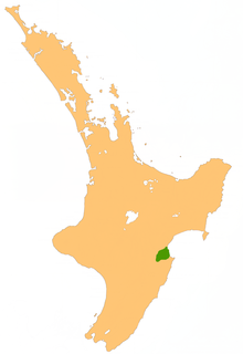
Hastings District is a territorial authority district within the Hawke's Bay Region, on the east coast of the North Island of New Zealand. It covers the southern half of the Hawke's Bay coast, excluding Napier City, which is a separate territorial authority. Hastings District Council is headquartered in the city of Hastings, the district's largest town.

Taradale is a suburb of the City of Napier, in the Hawke's Bay Region of the North Island of New Zealand. It is a predominantly middle-upper class residential suburb, located 10 kilometres southwest of the centre of Napier. The Taradale ward, which includes Greenmeadows, Meeanee, and Poraiti, had a population of 22,809 in the 2018 New Zealand census.

<span class="mw-page-title-main">Heretaunga Street</span>

Heretaunga Street is the main arterial road through Hastings City in New Zealand running from north-west to south-east.

<span class="mw-page-title-main">State Highway 2 (New Zealand)</span> Road in New Zealand

State Highway 2 runs north–south through eastern parts of the North Island of New Zealand from the outskirts of Auckland to Wellington. It runs through Tauranga, Gisborne, Napier, Hastings and Masterton. It is the second-longest highway in the North Island, after State Highway 1, which runs the length of both of the country's main islands.

The Hawke's Bay Expressway, known also as the Napier-Hastings Expressway, runs from Hawke's Bay Airport, through Napier and Hastings, and ends at Pakipaki, just south of Hastings, a total length of 24 km.

Te Awanga is a small rural beachside town in Hawke's Bay, New Zealand. Te Awanga is near Cape Kidnappers, which has a renowned colony of the Australasian gannet.

Rugby League Hawkes Bay is the local sporting body responsible for the administration of rugby league in the Hawke's Bay region of New Zealand. The RLHB run the local club competition and are responsible for the Hawke's Bay rugby league team. They are part of the New Zealand Rugby League's Mid-Central Zone and their players are eligible for the Central Vipers.

Eskdale is a rural settlement in the Hastings District and Hawke's Bay Region of New Zealand's North Island. It is located north of Napier on State Highway 5, near the mouth of the Esk River.

Pakipaki is a pā kāinga village and rural community in the Hastings District and Hawke's Bay Region of New Zealand's North Island. The village is home to many Ngāti Whatuiāpiti hapū tribes represented by their three marae of Houngarea, Mihiroa, and Taraia. The village is also the home of the Hawke's Bay Catholic Māori Mission and displays the Foundation Stone for the Catholic Church in Hawke's Bay. Pakipaki is a Sacred Space in the Footsteps of Venerable Suzanne Aubert.

Pakowhai is a small settlement in the Hastings District and Hawke's Bay Region of New Zealand's North Island. It is a located between Napier and Hastings, north of the Ngaruroro River.

State Highway 51 is a New Zealand state highway that runs between Napier and Hastings via Clive. Known locally as the Coastal Route, it was the main route between the two cities prior to the completion of the Hawke's Bay Expressway.

Hastings District Council is the territorial authority for the Hastings District of New Zealand.

Napier City Council is the territorial authority of Napier, Hawke's Bay Region, New Zealand.

References

  1. 1 2 "Subnational Population Estimates: At 30 June 2019". Statistics New Zealand. 22 October 2019. Retrieved 11 January 2020. For urban areas, "Subnational population estimates (UA, AU), by age and sex, at 30 June 1996, 2001, 2006–18 (2017 boundaries)". Statistics New Zealand. 23 October 2018. Retrieved 23 October 2018.
  2. "Ariā SNZ". aria.stats.govt.nz.
  3. "Hawke's Bay council merger recommended after Wellington super-city scrapped". 9 June 2015.
  4. "Hawke's Bay Reorganisation Poll : PROGRESS RESULT" (PDF). Electionz.com. Retrieved 17 June 2016.