A watermill or water mill is a mill that uses hydropower. It is a structure that uses a water wheel or water turbine to drive a mechanical process such as milling (grinding), rolling, or hammering. Such processes are needed in the production of many material goods, including flour, lumber, paper, textiles, and many metal products. These watermills may comprise gristmills, sawmills, paper mills, textile mills, hammermills, trip hammering mills, rolling mills, wire drawing mills.

The River Maun is a river in Nottinghamshire, England. Its source lies in Kirkby-in-Ashfield, and from there it flows north east through Mansfield, Edwinstowe and Ollerton, these being the heart of the Sherwood Forest area. It becomes known as Whitewater near the village of Walesby and connects to the River Meden temporarily where the Robin Hood Way crosses them. They diverge, and near Markham Moor it merges again with the River Meden this time becoming the River Idle. Its main tributaries are Rainworth Water, Vicar Water and Cauldwell Water.

The River Cray is the largest tributary of the Darent. It is the prime river of outer, south-east Greater London, rising in Priory Gardens, Orpington, where rainwater percolates through chalk bedrock of the Downs to forms a pond where the eroded ground elevation gives way to impermeable clay. Initially it flows true to form northwards, past industrial and residential St Mary Cray, through St Paul's Cray and through Foots Cray, where it enters the parkland Foots Cray Meadows, flowing under by Five Arches bridge. It then flows by restored Loring Hall (c.1760), home of the Lord Castlereagh who took his own life there in 1822. It continues through North Cray and Bexley. It neighbours a restored Gothic (architecture) cold plunge bath house, built around 1766 as part of Vale Mascal Estate. It is then joined by the River Shuttle and then continues through the parkland of Hall Place, which was built for John Champneys in 1540. The Cray turns eastward through Crayford and Barnes Cray to join the Darent in Dartford Creek. The Creek is a well-watered partly tidal inlet between Crayford Marshes and Dartford Marshes by a slight projection of land, Crayford Ness. The villages through which the Cray flows are collectively known as "The Crays".
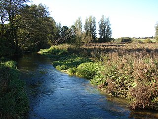
The Darent is a Kentish tributary of the River Thames and takes the waters of the River Cray as a tributary in the tidal portion of the Darent near Crayford, as illustrated by the adjacent photograph, snapped at high tide. 'Darenth' is frequently found in the spelling of the river's name in older books and maps, Bartholomew's "Canal's and River of England" being one example. Bartholomew's Gazetteer (1954) demonstrates that Darent means "clear water" and separately explains the other name. Considering the River Darent runs on a bed of chalk and its springs rise through chalk, this is not surprising. The original purity of the water was a major reason for the development of paper and pharmaceuticals in the area.
Buxton Mill, is located on the River Bure about 0.5 miles (0.80 km) east of the village of Buxton, Norfolk, and is in the hamlet of Lamas, Norfolk. A watermill was recorded here in the Domesday Book. The present mill is thought to date from 1754 and was built by William Pepper, a merchant living in Buxton.

The River Teise is a tributary of the River Medway in Kent, England. It begins in Dunorlan Park in Tunbridge Wells. and flows eastwards past Bayham Abbey and then through Lamberhurst. 2 miles downstream of Lamberhurst the small River Bewl, on which is the reservoir Bewl Water, joins the Teise.
The River Beult is a tributary of the River Medway in South East England. It has several sources west of Ashford, including one at Woodchurch. It then flows through Headcorn. At Hunton, 7 furlongs (1.4 km) above Yalding it is joined by the major stream of the River Teise. Town bridge lies 10 1⁄4 miles (16.5 km) from Allington, it is the longest mediaeval bridge in Kent. The river enters the Medway at Yalding. The River Beult is crossed by the railway between Headcorn and Staplehurst. The bridge was the scene of the Staplehurst rail crash in 1865 in which Charles Dickens was involved..
Narborough Bone Mill was a watermill that operated on the River Nar in the west of the English county of Norfolk. The watermill was 1 mile (1.6 km) downstream of the village of Narborough. The mill was built in the early part of the 19th century and records show that it was owned by the Marriott Brothers in 1830, who also owned the navigation rights on the river Nar. The site is currently owned by the Munford family of Narborough and is undergoing preservation work following a recent lottery grant. More info at bonemill.org.uk

Letheringsett watermill is situated on the River Glaven in the village of Letheringsett within the English county of Norfolk. Letheringsett is in the district of North Norfolk and is 1.4 miles (2.3 km) west of the town of Holt. The watermill is a Grade II* listed building and is the last fully operational watermill in Norfolk that produces flour.

The remains of Letheringsett Brewery Watermill are located in the centre of the village of Letheringsett in the county of Norfolk. The watermill of 1784 was housed within the maltings and brewery complex founded and run by John Brereton of Letheringsett Hall from before 1721. Much of this complex still stands on the south side of the A148 Cromer to King’s Lynn road, which bisects the village on an east-west axis, and on the west bank of the River Glaven, which bisects the village south-north.

White Mill is a smock mill west of Sandwich, Kent, England that was built in 1760. The mill has been restored and is open to the public as part of the White Mill Rural Heritage Centre. The museum also includes the miller's cottage, which has been furnished to appear as it did between 1900 and 1939. Other displays in the outbuildings include farming and craft tools, wheelwright and blacksmith workshops.
The Medway and its tributaries and sub-tributaries have been used for over 1,150 years as a source of power. There are over two hundred sites where the use of water power is known. These uses included corn milling, fulling, paper making, iron smelting, pumping water, making gunpowder, vegetable oil extraction, and electricity generation. Today, there is just one watermill working for trade. Those that remain have mostly been converted. Such conversions include a garage, dwellings, restaurants, museums and a wedding venue. Some watermills are mere derelict shells, lower walls or lesser remains. Of the majority, there is nothing to be seen. A large number of tributaries feed into the River Medway. The tributaries that powered watermills will be described in the order that they feed in. The mills are described in oder from source to mouth. Left bank and right bank are referred to as though the reader is facing downstream. This article covers the tributaries that feed in above Penshurst.
The Medway and its tributaries and sub-tributaries have been used for over 1,150 years as a source of power. There are over two hundred sites where the use of water power is known. These uses included corn milling, fulling, paper making, iron smelting, pumping water, making gunpowder, vegetable oil extraction, and electricity generation. Today, there is just one watermill working for trade. Those that remain have mostly been converted. Such conversions include a garage, dwellings, restaurants, museums and a wedding venue. Some watermills are mere derelict shells, lower walls or lesser remains. Of the majority, there is nothing to be seen. A large number of tributaries feed into the River Medway. The tributaries that powered watermills will be described in the order that they feed in. The mills are described in order from source to mouth. Left bank and right bank are referred to as though the reader is facing downstream. This article covers the watermills on the tributaries that feed in below Penshurst and above Yalding.
The River Medway and its tributaries and sub-tributaries have been used for more than 1,150 years as a source of power. There are over two hundred sites where the use of water power is known. Many different processes were performed by the use of water power:- corn milling, fulling, paper making, iron smelting, pumping water, making gunpowder, vegetable-oil extraction, and electricity generation. Today, there is just one watermill working for trade. Those that remain have mostly been converted. Such conversions include a garage, dwellings, restaurants, museums and a wedding venue. Some watermills are mere derelict shells, lower walls or lesser remains. Of the majority, there is nothing to be seen. A large number of tributaries feed into the River Medway. The tributaries that powered watermills will be described in the order that they feed in. The mills are described in order from source to mouth. Left bank and right bank are referred to as though the reader is facing downstream. This article deals with the watermills on the tributaries that feed in below Yalding.

Union Mills or Roy's Mills are a Grade II listed combined tower mill and watermill at Burnham Overy, Norfolk, England which has been converted to residential accommodation.

Bintry Watermill is located on the River Wensum, about a mile (2 km) west of the village of Bintree in the English county of Norfolk. The watermill is thought to have stood at this location since 1454. The present mill is thought to date from the 1750s
A gristmill grinds cereal grain into flour and middlings. The term can refer to both the grinding mechanism and the building that holds it.