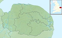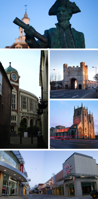
King's Lynn, known until 1537 as Bishop's Lynn and colloquially as Lynn, is a port and market town in the borough of King's Lynn and West Norfolk in the county of Norfolk, England. It is 36 miles (58 km) north-east of Peterborough, 44 miles (71 km) north-north-east of Cambridge and 44 miles (71 km) west of Norwich.

The Wash is a shallow natural rectangular bay and multiple estuary on the east coast of England in the United Kingdom. It is an inlet of the North Sea and is the largest multiple estuary system in the UK as well being the largest natural bay in England and is the outflow for the rivers Witham, Welland, Nene and the Great Ouse. It is also one of the most important places of conservation in Europe, with several nature reserves located within this area.

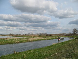
The River Great Ouse is a river in England, the longest of several British rivers called "Ouse". From Syresham in Northamptonshire, the Great Ouse flows through Buckinghamshire, Bedfordshire, Cambridgeshire and Norfolk to drain into the Wash and the North Sea near Kings Lynn. Authorities disagree both on the river's source and its length, with one quoting 160 mi (260 km) and another 143 mi (230 km). Mostly flowing north and east, it is the fifth longest river in the United Kingdom. The Great Ouse has been historically important for commercial navigation, and for draining the low-lying region through which it flows; its best-known tributary is the Cam, which runs through Cambridge. Its lower course passes through drained wetlands and fens and has been extensively modified, or channelised, to relieve flooding and provide a better route for barge traffic. The unmodified river would have changed course regularly after floods.
The River Little Ouse, also known as the Brandon River, is a river in the east of England, a tributary of the River Great Ouse. For much of its length it defines the boundary between Norfolk and Suffolk.

The River Wissey is a river in Norfolk, eastern England. It rises near Bradenham, and flows for nearly 31 miles (50 km) to join the River Great Ouse at Fordham. The lower 11.2 miles (18.0 km) are navigable. The upper reaches are notable for a number of buildings of historic interest, which are close to the banks. The river passes through the parkland of the Arts and Crafts Pickenham Hall, and further downstream, flows through the Army's Stanford Training Area (STANTA), which was created in 1942 by evacuating six villages. The water provided power for at least two mills, at Hilborough and Northwold. At Whittington, the river becomes navigable, and is surrounded by fenland. A number of pumping stations pump water from drainage ditches into the higher river channel.

The River Maun is a river in Nottinghamshire, England. Its source lies in Kirkby-in-Ashfield, and from there it flows north east through Mansfield, Edwinstowe and Ollerton, these being the heart of the Sherwood Forest area. It becomes known as Whitewater near the village of Walesby and connects to the River Meden temporarily where the Robin Hood Way crosses them. They diverge, and near Markham Moor it merges again with the River Meden this time becoming the River Idle. Its main tributaries are Rainworth Water, Vicar Water and Cauldwell Water.

Downham Market, sometimes simply referred to as Downham, is a market town and civil parish in Norfolk, England. It lies on the edge of the Fens, on the River Great Ouse, approximately 11 miles south of King's Lynn, 39 miles west of Norwich and 30 miles north of Cambridge.
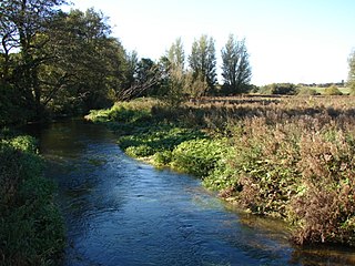
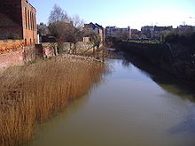
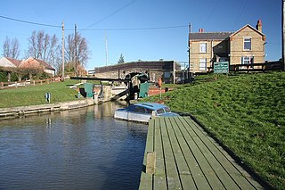
The River Nar is a river in England, a tributary of the River Great Ouse. It rises at Mileham near Litcham in Norfolk and flows 15 miles west through Castle Acre and Narborough, joining the Ouse at King's Lynn. It has had a variety of alternative names, such as the Setch, the Sandringham, and Lynn Flu, though these are rarely, if ever, used today. In 2011 the Nar was recognised by the Environment Agency as one of the top ten most improved rivers in England and Wales.

Bourne Eau is a short river which rises from an artesian spring in the town of Bourne in Lincolnshire, England, and flows in an easterly direction to join the River Glen at Tongue End. Within the town, it once powered three water mills, one of which is now a heritage centre. At Eastgate, it becomes much wider as it was navigable in the 18th and 19th centuries, and this was the location of the terminal basin. Below the town it is an embanked river, as its normal level is higher than that of the surrounding Fens. Navigation ceased in the 1860s and the river now forms an important part of the drainage system that enables the surrounding fen land to be used for agriculture.

King's Lynn railway station is the northern terminus of the Fen line in the east of England, serving the town of King's Lynn, Norfolk. It is 41 miles 47 chains (66.9 km) from Cambridge and 96 miles 75 chains (156.0 km) measured from London Liverpool Street.

The A1065 is a main road in the English region of East Anglia. It provides the principal road connection to parts of the west and north of the county of Norfolk from Newmarket and points south of there, including London. It runs from a junction near Mildenhall, to a junction on the western outskirt of Fakenham.

The River Babingley is a chalk stream and minor river in the northwest of Norfolk in England. It runs 12.2 miles (19.6 km) from its source at Flitcham to the River Great Ouse at Wootton Marshes where it terminates.

The River Lavant is a winterbourne that rises at East Dean and flows west to Singleton, then south past West Dean and Lavant to Chichester. From east of Chichester its natural course was south to the sea at Pagham, but the Romans diverted it to flow around the southern walls of Chichester and then west into Chichester Harbour.

Beeston Beck is a minor watercourse in the north of the county of Norfolk, England.

Scarrow Beck is a minor watercourse which rises in the north of the English county of Norfolk. It is a tributary of the River Bure. Its spring is in the North Norfolk village of Aylmerton west of the main street. It eventually merges, after 7.7 miles (12.4 km) with the River Bure at Ingworth just north of the Blickling Hall estate. There are two watermills on the beck, both of which are no longer in working order. A third windmill at Gresham stands on Gur Beck, a small tributary of Scarrow Beck.
National Cycle Route 11 is a bikeway in England on the UK's National Cycle Network, connecting Harlow in Essex to King's Lynn in Norfolk.
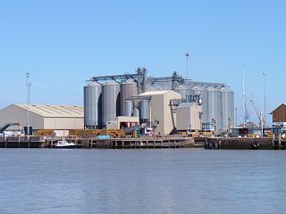
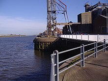
King's Lynn Docks are located to the north of the town of King's Lynn in the English county of Norfolk. They are on the River Great Ouse which provides access to the North Sea via the Lynn Channel and The Wash. They are located 39 miles (63 km) north of Cambridge, 40 miles (64 km) west of Norwich and 92 miles (148 km) north of London on the A1078 Edward Benefer Way.
Outwell is a village and civil parish in the borough of King's Lynn and West Norfolk, in the English county of Norfolk.
Downham West is a civil parish in the English county of Norfolk The parish is 47.6 miles (76.6 km) west of Norwich, 16.3 miles (26.2 km) south-south-west of King's Lynn and 96.2 miles (154.8 km) north of London. The nearest town is Downham Market which is 2.5 miles (4.0 km) north east of the parish. The nearest railway station is at Downham Market for the Fen Line which runs between King's Lynn and Cambridge. The nearest airport is Norwich International Airport. The parish of Downham West, in the 2001 census, has a population of 285, rising marginally to 286 at the Census 2011. For the purposes of local government, the parish falls within the district of King's Lynn and West Norfolk.
Stony Brook is a 8.5-mile (13.7 km)-long subterranean river in Boston. The largest tributary stream of the lower Charles River, it runs mostly through conduits. Stony Brook originates at Turtle Pond in the Stony Brook Reservation and flows through Hyde Park, Roslindale, Jamaica Plain, and Roxbury. It empties into the Charles River Basin just upstream of the Harvard Bridge. Stony Brook is fed by four tributaries, all of which are partially or entirely in conduits as well.