The River Wensum is a chalk river in Norfolk, England and a tributary of the River Yare, despite being the larger of the two rivers. The river is a biological Site of Special Scientific Interest and Special Area of Conservation.

A watermill or water mill is a mill that uses hydropower. It is a structure that uses a water wheel or water turbine to drive a mechanical process such as milling (grinding), rolling, or hammering. Such processes are needed in the production of many material goods, including flour, lumber, paper, textiles, and many metal products. These watermills may comprise gristmills, sawmills, paper mills, textile mills, hammermills, trip hammering mills, rolling mills, and wire drawing mills.

The River Eden is a tributary of the River Medway in south east England. It rises at the foot of the North Downs escarpment near Titsey in Surrey and runs initially southwards through Oxted before turning eastwards to enter Kent. After flowing through Edenbridge and passing Hever Castle, the Eden meets the Medway at Penshurst.

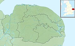
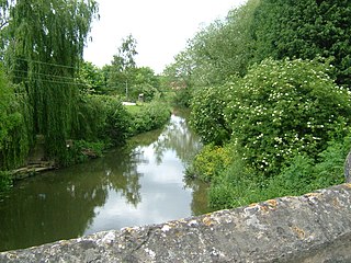
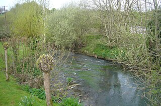
The River Glaven in the eastern English county of Norfolk is 10.5 mi (16.9 km) long and flows through picturesque North Norfolk countryside to the North Sea. Rising from a tiny headwater in Bodham the river starts 2+1⁄2 miles before Selbrigg Pond where three small streams combine. The scenic value of the Glaven valley is important to the tourist industry in North Norfolk. The river is one of over 200 chalk rivers in the world and one of 160 in the UK.
Buxton Mill, is located on the River Bure about 0.5 miles (0.80 km) east of the village of Buxton, Norfolk, and is in the hamlet of Lamas, Norfolk. A watermill was recorded here in the Domesday Book. The present mill is thought to date from 1754 and was built by William Pepper, a merchant living in Buxton.

The River Mun or Mundesley Beck is a river in the north of the county of Norfolk, England. Its source is in the parish of Northrepps. The river finally runs into the North Sea in the village of Mundesley.

Scarrow Beck is a minor watercourse which rises in the north of the English county of Norfolk. It is a tributary of the River Bure. Its spring is in the North Norfolk village of Aylmerton west of the main street. It eventually merges, after 7.7 miles (12.4 km) with the River Bure at Ingworth just north of the Blickling Hall estate. There are two watermills on the beck, both of which are no longer in working order. A third windmill at Gresham stands on Gur Beck, a small tributary of Scarrow Beck.
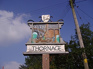
Thornage is a village and a civil parish in the English county of Norfolk. The village is 2.7 miles south-west of Holt, 23.2 miles north-west of Norwich and 11.3 miles east of Fakenham, and straddles the B1110 road between Holt and Guist. The nearest railway station is at Sheringham for the Bittern Line which runs between Sheringham, Cromer and Norwich. The nearest airport is at Norwich International Airport.
The River Beult is a tributary of the River Medway in South East England.
The Bybrook, also known as the By Brook, is a small river in England. It is a tributary of the Bristol Avon and is some 12 miles (19 km) long. Its sources are the Burton Brook and the Broadmead Brook, which rise in South Gloucestershire at Tormarton and Cold Ashton respectively, and join just north of Castle Combe in Wiltshire. The river has a mean flow rate of 57.25 cubic feet per second (1.621 m3/s) as recorded at Middlehill near Box. A variety of flora and fauna is supported by the river including the endangered white-clawed crayfish. Twenty watermill sites have been identified on the river but none now remain in use.

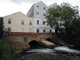
Letheringsett watermill is situated on the River Glaven in the village of Letheringsett within the English county of Norfolk. Letheringsett is in the district of North Norfolk and is 1.4 miles (2.3 km) west of the town of Holt. The watermill is a Grade II* listed building and is the last fully operational watermill in Norfolk that produces flour. See inside and explore the watermill here

Glandford watermill is situated on the River Glaven a little north of the village of Glandford within the English county of Norfolk. Glandford is in the civil parish of Wiveton within the district of North Norfolk.

The remains of Letheringsett Brewery Watermill are located in the centre of the village of Letheringsett in the county of Norfolk. The watermill of 1784 was housed within the maltings and brewery complex founded and run by John Brereton of Letheringsett Hall from before 1721. Much of this complex still stands on the south side of the A148 Cromer to King's Lynn road, which bisects the village on an east–west axis, and on the west bank of the River Glaven, which bisects the village south–north.
The Medway and its tributaries and sub-tributaries have been used for over 1,150 years as a source of power. There are over two hundred sites where the use of water power is known. These uses included corn milling, fulling, paper making, iron smelting, pumping water, making gunpowder, vegetable oil extraction, and electricity generation. Today, there is just one watermill working for trade. Those that remain have mostly been converted. Such conversions include a garage, dwellings, restaurants, museums and a wedding venue. Some watermills are mere derelict shells, lower walls or lesser remains. Of the majority, there is nothing to be seen. A large number of tributaries feed into the River Medway. The tributaries that powered watermills will be described in the order that they feed in. The mills are described in order from source to mouth. Left bank and right bank are referred to as though the reader is facing downstream. This article covers the tributaries that feed in above Penshurst.
The Medway and its tributaries and sub-tributaries have been used for over 1,150 years as a source of power. There are over two hundred sites where the use of water power is known. These uses included corn milling, fulling, paper making, iron smelting, pumping water, making gunpowder, vegetable oil extraction, and electricity generation. Today, there is just one watermill working for trade. Those that remain have mostly been converted. Such conversions include a garage, dwellings, restaurants, museums and a wedding venue. Some watermills are mere derelict shells, lower walls or lesser remains. Of the majority, there is nothing to be seen. A large number of tributaries feed into the River Medway. The tributaries that powered watermills will be described in the order that they feed in. The mills are described in order from source to mouth. Left bank and right bank are referred to as though the reader is facing downstream. This article covers the watermills on the tributaries that feed in below Penshurst and above Yalding.

Hunworth is a village and former civil parish, now in the parish of Stody, in the North Norfolk district, in the county of Norfolk, England. The village is 11.5 miles (18.5 km) east-north-east of the town of Fakenham, 12.6 miles (20.3 km) west-south-west of Cromer and 125 miles (201 km) north-north-east of London. The nearest town is Holt which lies 3.4 miles (5.5 km) north of the village. The nearest railway station is at Sheringham for the Bittern Line which runs between Sheringham, Cromer and Norwich. The nearest airport is Norwich International Airport. The village is situated on the road between Holt and Briston. In 1931 the parish had a population of 173.

Ifield Water Mill is a 19th-century weatherboarded watermill in the Ifield neighbourhood of Crawley, a town and borough in West Sussex, England. Built on the site of an earlier, smaller flour mill, which itself replaced an iron forge—one of many in the Crawley area—it fell into disuse in the 1930s. The local council, which acquired the land for housing development in the 1970s, leased the mill to local enthusiasts, who restored it to working order. The mill and an associated house are listed buildings, and there is also a cottage on the site.

The International Wind- and Watermill Museum, at Gifhorn in the German state of Lower Saxony, is the only one of its kind in Europe. On the museum's open-air site, which covers an area of around 16 hectares, there are currently 16 mills from 12 different countries. The mills are either original or faithful reproductions and are set in landscapes typical of their origins. Right across the site are historic artefacts associated with mills and the milling industry. The museum site is easily accessed by road; nearby is the intersection between the B 4 and B 188 federal highways. The museum is station 65 on the Lower Saxon Mill Road.

Narborough Watermill is located on the river Nar, within the village of Narborough in the English county of Norfolk. The watermill is thought to have been built around 1780 and is a Grade II listed building

The Land Yeo is a small river which flows through North Somerset, England. It rises on Dundry Hill and supplies Barrow Gurney Reservoirs before flowing through various villages to Clevedon where it drains into the Severn Estuary. During the past 1,000 years it has powered at least ten watermills; however, only one is still functional. Since 2003 initiatives have been undertaken to clean up the river, improving water quality and encouraging wildlife.