River Yare

Last updated

Yare
River Yare Thorpe.JPG
The river at Thorpe Green, Norwich
Norfolk UK relief location map.jpg
Red pog.svg
Location of the river mouth within Norfolk
Location
Country England
Region Norfolk
Physical characteristics
Source 
  locationwest of Shipdham
  coordinates 52°37′11″N0°50′19″E / 52.6196°N 0.8386°E / 52.6196; 0.8386
  elevation79 m (259 ft)
Mouth Breydon Water
  location
Burgh Castle
  coordinates
52°35′17″N1°38′33″E / 52.58798°N 1.64262°E / 52.58798; 1.64262
  elevation
0 m (0 ft)
Length83.5 km (51.9 mi)
Basin features
River system River Wensum
River Yare
BSicon uexKHSTa.svg
Source near Shipdham
BSicon uexCONTgq.svg
BSicon uexABZg+r.svg
Blackwater River
BSicon uxmKRZu.svg
railway bridge Mid Norfolk Railway
BSicon uexCONTgq.svg
BSicon uexABZg+r.svg
River Tiffey
BSicon uexSKRZ-Au.svg
A47 Bridge, Bawburgh
BSicon uexSKRZ-Yu.svg
B1108 bridge, Colney
BSicon uexSKRZ-Au.svg
A11 Bridge
BSicon CONTgq.svg
BSicon uxmKRZu.svg
BSicon CONTfq.svg
3 railway bridges
BSicon uexSKRZ-Au.svg
A140 Bridge
BSicon CONTgq.svg
BSicon uxmKRZu.svg
BSicon CONTfq.svg
3 railway bridges
BSicon uexCONTgq.svg
BSicon uexFKRZ.svg
BSicon uexSTR+r.svg
River Tas
BSicon uexSKRZ-Au.svg
A146 Road Bridge
BSicon uxWEIRg.svg
BSicon uMILL.svg
TrowseMills
BSicon uABZg+l.svg
BSicon uSTRr.svg
Limit of navigation
BSicon uSTR.svg
BSicon uFABZgl+l.svg
BSicon uSTRq.svg
BSicon uCONTfq.svg
River Wensum
(to Norwich city centre)
BSicon uSTR.svg
BSicon STR+l.svg
BSicon CONTfq.svg
railway line to Norwich
BSicon uABZgl.svg
BSicon mKRZo.svg
BSicon uSTR+r.svg
BSicon uSTR.svg
BSicon STR.svg
BSicon uSTR.svg
New Cut and old course
BSicon uABZg+l.svg
BSicon mKRZo.svg
BSicon uSTRr.svg
BSicon uSTR.svg
BSicon STRl.svg
BSicon CONTfq.svg
Bittern Line and Wherry Lines
BSicon uSKRZ-Au.svg
A47 Bridge
BSicon uDOCKS.svg
BSicon uFABZgr+r.svg
Surlingham Broad
BSicon ueABZg+l.svg
BSicon uexCONTfq.svg
Lackford Run
BSicon uSTR+l.svg
BSicon uABZgr.svg
The Fleet
BSicon uDOCKS.svg
BSicon uSTR.svg
Rockland Broad
BSicon uSTRl.svg
BSicon uABZg+r.svg
Short Dike
BSicon uSTRwmr.svg
Buckenham Ferry Drainage Mill
BSicon ueABZg+l.svg
BSicon uexCONTfq.svg
Hassingham Drain
BSicon uCONTgq.svg
BSicon uFABZgr+r.svg
Langley Staithe
BSicon uSTRwml.svg
Hardley Drainage Mill
BSicon uCONTgq.svg
BSicon uFABZgr+r.svg
Hardley Dyke
BSicon uSTRwmr.svg
Limpenhoe Drainage Mill
BSicon uCONTgq.svg
BSicon uFABZgr+r.svg
River Chet
BSicon uSTRwml.svg
Norton Drainage Mill
BSicon uSTR+FEATURE@l.svg
Reedham Ferry
BSicon CONTgq.svg
BSicon umKRZusw.svg
BSicon CONTfq.svg
Reedham Swing Bridge
BSicon uSTR+l.svg
BSicon uFABZqlr.svg
BSicon uSTR+r.svg
Jn with Haddiscoe Cut
BSicon uSTR.svg
BSicon uSTRwmr.svg
Polkey's Drainage Mill
BSicon uSTR.svg
BSicon uSTRwmr.svg
Cadge's Drainage Mill
BSicon uSTR.svg
BSicon uSTRwml.svg
Langley Detached Drainage Mill
BSicon uSTR.svg
BSicon uSTRwmr.svg
Berney Arms Drainage Mill
BSicon uFABZgl+l.svg
BSicon uSTRq.svg
BSicon uFABZgr+r.svg
River Waveney
BSicon uCONTf.svg
BSicon uDOCKSa.svg
Breydon Water
BSicon uDOCKSe.svg
BSicon uSKRZ-Au.svg
A47 Breydon Bridge
BSicon uSTR+l.svg
BSicon uFABZqlr.svg
BSicon uCONTfq.svg
River Bure
BSicon uSTR+FEATURE@l.svg
Great Yarmouth
BSicon uSTRl.svg
BSicon uDOCKSl.svg
North Sea

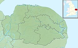
The River Yare is a river in the English county of Norfolk. In its lower reaches it is one of the principal navigable waterways of The Broads and connects with the rest of the network.

Contents

The river rises south of Dereham to the west to the village of Shipdham. Above its confluence with a tributary stream from Garvestone it is known as the Blackwater River. [1] From there it flows in a generally eastward direction passing Barnham Broom and is joined by the River Tiffey before reaching Bawburgh. It then skirts the southern fringes of the city of Norwich, passing through Colney, Cringleford, Lakenham and Trowse. At Whitlingham it is joined by the River Wensum and although the Wensum is the larger and longer of the two, the river downstream of their confluence continues to be called the Yare. Flowing eastward into The Broads it passes the villages of Bramerton, Surlingham, Rockland St. Mary and Cantley. Just before Reedham at Hardley Cross (erected in 1676 [2] ) it is joined by the River Chet. The cross marks the ancient boundary between the City of Norwich and Borough of Great Yarmouth. Beyond Reedham the river passes the famously isolated marshland settlement of Berney Arms before entering the tidal lake of Breydon Water. Here the Yare is joined by the Rivers Waveney and Bure and finally enters the North Sea at Gorleston, Great Yarmouth. [3] [4]

The Yare is the frequent subject of landscape paintings by members of the early 19th century Norwich School of artists. The National Gallery of Art in Washington D.C. contains an oil painting by John Crome entitled Moonlight on the Yare. Joseph Stannard depicted the river in Thorpe Water Frolic, Afternoon (1824) and Boats on the Yare near Bramerton (1828) which is in the Fitzwilliam Museum, Cambridge.

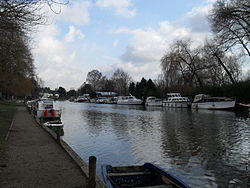
The river is navigable to small coastal vessels from Norwich to the sea, and in former times carried significant commercial traffic to that city. At Reedham the river is joined by the Haddiscoe Cut, a canal which provides a direct navigable link to the River Waveney at Haddiscoe avoiding Breydon Water.

The river provides a navigable link between Norwich and the North Sea, but silting has been a long-standing problem. In 1698, an Act of Parliament was obtained which allowed duty to be collected for any coal traffic using the river. The money raised was to pay for improvements to the course of the river and to the harbour at Great Yarmouth, but the majority of it went towards harbour improvements, and little improvement of the river occurred. Three more acts attempted to rectify the situation, but the river continued to be neglected. A fifth act, obtained in 1772, sought to address the problem in a different way, and specified how the tolls were to be used. 15 per cent was to be given to Norwich for river improvements between the city and Hardley Cross, 25 per cent was given to Yarmouth for improvements to the lower river between Hardley Cross and the town, with a further 40 per cent set aside for maintenance of Yarmouth harbour. Other rivers benefitted from the remaining 20 per cent. [5]

The size of vessels that could reach Norwich was limited by the shallow channel crossing Breydon Water, and so all goods arriving from the North Sea had to be trans-shipped to smaller vessels at Yarmouth. In order to improve the situation the merchants of Norwich asked William Cubitt to look for a solution in 1814. His proposal consisted of dredging a new channel to the south side of Breydon Water and making various improvements to the river. This was costed at £35,000, but the plan was opposed by Yarmouth Corporation when it was made public in 1818. John Rennie, acting for the corporation, concluded that the plan might result in silting of the harbour, and so Cubitt proposed an alternative, which would link the Yare to Lowestoft. This was also opposed by Yarmouth Corporation, but despite the cost being more than double,[ clarification needed ] and assurances from Thomas Telford and James Walker that improved navigation to Norwich would not harm Yarmouth, this was the plan that was laid before Parliament in 1826. [5]

The Act would authorise dredging of the Yare between Norwich and Reedham, from where a 2+12-mile (4 km) canal would be built to connect to the River Waveney at Haddiscoe. Oulton Dyke would be enlarged, and a cut and lock built to link Oulton Broad to Lake Lothing, and hence the North Sea. At the formal enquiry, six engineers gave evidence for the proposal, but the opposition of Yarmouth and local landowners who feared potential flooding resulted in the bill being narrowly defeated. Similar plans were submitted in the next parliamentary session, with Yarmouth spending £8,000 to ensure its defeat. Evidence for the plan included details of widespread theft during the transshipment process at Yarmouth. A man had hidden in a wicker basket to record the conversations and activities of the thieves, and ultimately 18 men were convicted of taking the goods and one of receiving it. The Act was granted on 28 May 1827. [5]

The Act allowed the Norwich and Lowestoft Navigation Company to raise £100,000 as capital, with an additional £50,000 if necessary. Work started at the Lowestoft end, with Alderman Crisp Brown of Norwich cutting the first sod in the autumn. The lock and channel between Oulton Broad and Lake Lothing were completed by 1829, and the first vessel used Lowestoft harbour on 3 June 1831. Costs overran, and to complete the Haddiscoe cut, the additional £50,000 authorised by the Act was raised by taking a loan from the Exchequer Bill Loan Commissioners. The cut was completed in 1832, and the improvements of the remaining 32 miles (51 km) to Norwich were finished by the autumn of 1833. A grand opening was held on 30 September 1833, when it was planned that the Jarrow would tow two vessels, the City of Norwich and the Squire, which were moored at Lowestoft, to Norwich. Unfortunately, the Jarrow was at Yarmouth, and the Corporation refused to open the bridge at the head of Breydon Water to allow the vessel to pass. The captain eventually cut down the funnel, but the delay resulted in him missing the tide, and he had to wait to cross Breydon Water. The convoy reached Norwich the following day, where 10,000 people lined the banks of the river to witness the event. [5]

Despite high hopes, the venture was not a success, as operating costs exceeded revenue, and the loan from the Exchequer Bill Loan Commission could not be repaid. The arrival of the railways added an element of competition, and the Commissioners took over the Haddiscoe Cut in 1842, selling it on to Sir Samuel Morton Peto, a railway developer. [5] A new cut was made at Thorpe in 1844, where the railway crossed a loop in the river. The bridges at both ends of the old course restrict headroom to about 6 feet (1.8 m). [6] The City of Norwich attempted to buy the navigation in 1848, but were again opposed by Yarmouth, and withdrew their bill from Parliament. Silting of Lake Lothing became a problem, and traffic gradually reverted to using the route through Yarmouth. A grandiose plan to build a ship canal between Yarmouth and Norwich with a commercial dock at Whitlingham and a naval base at Rockland Broad, proposed in 1908, came to nothing, but steam tugs continued to haul barges of coal to Norwich until the 1960s. Commercial traffic has now been replaced by leisure boating. [5]

The river is tidal as far as Trowse Mills, with a tidal range of 2+12 to 3 feet (0.76 to 0.91 m) at Reedham and 1+12 to 2 feet (0.46 to 0.61 m) at Norwich. High water at Reedham occurs some 1+12 hours after high water at Yarmouth, and at Norwich it is 4+12 hours after Yarmouth. [6]

Hydronymy

The derivation of the name has been the subject of debate, M. R. James states that the Saxon Shore fort, Gariannonum (which he identified as Burgh Castle) takes its name from the original Common Celtic name for the Yare. [7] Ptolemy records a Latinized version of this name as Gariennos around 150 AD. [8] Eilert Ekwall gives another derivation, that the river name is a back-formation from Yarmouth.[ citation needed ]

Wherryman's Way

Opened in 2005, the 35 mile long Wherryman's Way follows the route of the historic Broads trading wherries between Norwich and Great Yarmouth. It winds through existing footpaths, open marshes, reedbeds, grazing meadows and riverside villages along the banks of the River Yare. The path passes numerous information panels, sculptures and audio posts which seek to bring to life the characters and history of the route. [9]

Related Research Articles

<span class="mw-page-title-main">The Broads</span> Network of rivers and lakes in East Anglia

The Broads is a network of mostly navigable rivers and lakes in the English counties of Norfolk and Suffolk. Although the terms "Norfolk Broads" and "Suffolk Broads" are correctly used to identify specific areas within the two counties respectively, the whole area is frequently referred to as the Norfolk Broads.

<span class="mw-page-title-main">River Waveney</span> River in east England

The River Waveney is a river which forms the boundary between Suffolk and Norfolk, England, for much of its length within The Broads. The "ey" part of the name means "river" thus the name is tautological.

<span class="mw-page-title-main">Lowestoft</span> Town and civil parish in Suffolk, England

Lowestoft is a coastal town and civil parish in the East Suffolk district of Suffolk, England. As the most easterly UK settlement, it is 110 miles (177 km) north-east of London, 38 miles (61 km) north-east of Ipswich and 22 miles (35 km) south-east of Norwich, and the main town in its district. The estimated population in the built-up area exceeds 70,000. Its development grew with the fishing industry and as a seaside resort with wide sandy beaches. As fishing declined, oil and gas exploitation in the North Sea in the 1960s took over. While these too have declined, Lowestoft is becoming a regional centre of the renewable energy industry.

<span class="mw-page-title-main">Breydon Water</span>

Breydon Water is a 514.4-hectare (1,271-acre) biological Site of Special Scientific Interest at Great Yarmouth, Norfolk. It is a Local Nature Reserve, a Ramsar site and a Special Protection Area. It is part of the Berney Marshes and Breydon Water nature reserve, which is managed by the Royal Society for the Protection of Birds (RSPB).

<span class="mw-page-title-main">Haddiscoe Cut</span>

The Haddiscoe Cut or New Cut is a canal in the English county of Norfolk and in The Broads National Park.). The cut was conceived as a way to provide a more direct route from Lowestoft to Norwich, and was built as part of a larger scheme which included the linking of the River Waveney to Oulton Broad and Lake Lothing. It was opened in 1833, but the new route was not a financial success, and it was sold to a railway developer in 1842. It remained in railway ownership until Nationalisation in 1948, and was damaged by floods in 1953. An attempt to close it in 1954 was resisted by local interests, resulting in it being repaired. It is now managed by the Environment Agency.

<span class="mw-page-title-main">River Chet</span> River in South Norfolk, England

The River Chet is a small river in South Norfolk, England, a tributary of the River Yare. It rises in Poringland and flows eastwards through Alpington, Bergh Apton, Thurton and Loddon. At Loddon it passes under the A146 through Loddon Mill and into Loddon Staithe. From this point onwards the river is navigable. It then passes Hardley Flood to the north, a nature reserve part-managed by the Norfolk Wildlife Trust. The river finally joins the River Yare one mile west of Reedham at Hardley Cross, erected in 1676, which marks the ancient boundary between the City of Norwich and the Borough of Great Yarmouth. The total navigable length is some 3½ miles.

<span class="mw-page-title-main">Reedham railway station (Norfolk)</span> Railway station in Norfolk, England

Reedham railway station is on the Wherry Lines in the East of England, serving the village of Reedham, Norfolk. It is 12 miles 13 chains (19.6 km) down the line from Norwich and is situated between Cantley to the west and, to the east, Berney Arms on the Great Yarmouth branch or Haddiscoe on the Lowestoft branch. It is commonly suffixed as Reedham (Norfolk) in order to distinguish it from the station of the same name in south London. Its three-letter station code is REE.

<span class="mw-page-title-main">Lowestoft railway station</span> Railway station in Suffolk, England

Lowestoft railway station serves the town of Lowestoft, Suffolk. It is the eastern terminus of the East Suffolk Line from Ipswich and is one of two eastern termini of the Wherry Lines from Norwich. Lowestoft is 23 miles 41 chains (37.8 km) down the line from Norwich and 48 miles 75 chains (78.8 km) measured from Ipswich; it is the easternmost station on the National Rail network in the United Kingdom.

Lothingland is an area in the English counties of Suffolk and Norfolk on the North Sea coast. It is bound by the River Yare and Breydon Water to the north, the River Waveney to the west and Oulton Broad to the south, and includes the parts of Lowestoft north of Lake Lothing.

<span class="mw-page-title-main">Haddiscoe</span> Human settlement in England

Haddiscoe is a village and civil parish in the South Norfolk district of Norfolk, England, about 16 miles (26 km) southeast of Norwich. The parish is on the county boundary with Suffolk, about 7 miles (11 km) west-northwest of Lowestoft. The parish includes the hamlet of Thorpe-next-Haddiscoe, about 1 mile (1.6 km) north of Haddiscoe village.

<span class="mw-page-title-main">Wherryman's Way</span> Long-distance footpath in Norfolk, England

Wherryman's Way is a long-distance footpath in the English county of Norfolk.

<span class="mw-page-title-main">A146 road</span> A road in East Anglia, England

The A146 is an A road that connects Norwich in Norfolk and Lowestoft in Suffolk, two of East Anglia's largest population centres. It is around 27 miles (43 km) in length and has primary classification along its entire route. It is mainly single carriageway throughout its route, with the exception of a section of dual carriageway on the southern edge of Norwich.

Bramerton is a village in South Norfolk 4¾ miles south-east of Norwich, just north of the main A146 Norwich-Lowestoft road and on the south bank of the River Yare.

<span class="mw-page-title-main">Trowse</span> Human settlement in England

Trowse, also called Trowse with Newton, is a village in South Norfolk which lies about 1+12 miles (2.4 km) south-east of Norwich city centre on the banks of the River Yare. It covers an area of 4.49 km2 (1.73 sq mi) and had a population of 479 in 233 households at the 2001 census, the population increasing to 862 in 374 households at the 2011 Census. There are approved plans to build a further 770 houses on the outskirts of the village, at White Horse Lane* and the Deal Ground sites.*the new development off White Horse Lane is called Millgate Meadow and consists of 98 houses already built in phase 1 and a further 85 as stage 2 ready in early 2024. The proposal for the May Gurney site is a further 80 homes with 600 on the Deal Ground site which is in the Norwich City Council boundary but the access for all homes is via Trowse.

<span class="mw-page-title-main">Berney Arms Windmill</span> Windmill in Norfolk, England

Berney Arms Windmill is a tower mill located at Berney Arms alongside the River Yare at the south-western end of Breydon Water in the English county of Norfolk. The windmill is in an isolated spot in The Broads around 3.5 miles (5.6 km) north-east of the village of Reedham and 4 miles (6.4 km) south-west of Great Yarmouth. The mill has no road access but can be accessed by boat, by foot or from Berney Arms railway station. It is a scheduled monument under the care of English Heritage.

The Yarmouth–Beccles line was a railway line which linked the Suffolk market town of Beccles with the Norfolk coastal resort of Yarmouth. Forming part of the East Suffolk Railway, the line was opened in 1859 and closed 100 years later in 1959.

<span class="mw-page-title-main">Port of Lowestoft</span>

The Port of Lowestoft is a harbour and commercial port in Lowestoft in the English county of Suffolk owned by Associated British Ports. It is the most easterly harbour in the United Kingdom and has direct sea access to the North Sea. The harbour is made up of two sections divided by a bascule bridge. The inner harbour is formed by Lake Lothing whilst the outer harbour is constructed from breakwaters. Lowestoft handles around 30,000 tonnes of cargo per year.

Mutford and Lothingland was a hundred of Suffolk, with an area of 33,368 acres (135.04 km2). Lowestoft Ness, the most easterly point of Great Britain fell within its bounds.

<span class="mw-page-title-main">Norfolk Railway</span> Railway company in Norfolk, England operating from 1845 to 1862

The Norfolk Railway was an early railway company that controlled a network of 94 miles around Norwich, England. It was formed in 1845 by the amalgamation of the Yarmouth and Norwich Railway opened in 1844, and the Norwich and Brandon Railway, not yet opened. These lines were built out of frustration that the Eastern Counties Railway line that was expected to connect Norwich to London failed to be completed. The Norfolk Railway also leased the Lowestoft Railway and Harbour company, and built a branch to Dereham and Fakenham, opened in 1846 and 1849 respectively.

This article describes the geology of the Broads, an area of East Anglia in eastern England characterised by rivers, marshes and shallow lakes (‘broads’). The Broads is designated as a protected landscape with ‘status equivalent to a national park’.

References

  1. Ordnance Survey of Great Britain
  2. Norwich Boundary Crosses Archived 2006-10-13 at the Wayback Machine
  3. Ordnance Survey (2005). OS Explorer Map OL40 - The Broads. ISBN   0-319-23769-9.
  4. Ordnance Survey (1999). OS Explorer Map 237 - Norwich. ISBN   0-319-21868-6.
  5. 1 2 3 4 5 6 Boyes, John; Russel, Ronald (1977). The Canals of Eastern England. Newton Abbot. ISBN   978-0-7153-7415-3. OCLC   3650731.[ page needed ]
  6. 1 2 Inland Waterways of Great Britain, (2009), Jane Cumberlidge, Imray Laurie Norie and Wilson, ISBN   978-1-84623-010-3
  7. James, Montague Rhodes (2013). Complete Works of M. R. James. Delphi Classics. ISBN   1909496707.
  8. Jacek Fisiak; Peter Trudgill, eds. (2001). East Anglian English (1. publ ed.). Woodbridge, Suffolk: Brewer. p. 40. ISBN   9780859915717.
  9. Wander the Wherryman's Way - Broads Authority