National Register of Historic Places listings in Chugach Census Area, Alaska

Last updated
Location of the Valdez-Cordova Census Area in Alaska Map of Alaska highlighting Chugach Census Area.svg
Location of the Valdez-Cordova Census Area in Alaska

This is a list of the National Register of Historic Places listings in Chugach Census Area, Alaska.

Contents

This is intended to be a complete list of the properties and districts on the National Register of Historic Places in Chugach Census Area, Alaska, United States. The locations of National Register properties and districts for which the latitude and longitude coordinates are included below, may be seen in a Google map. [1]

There are 10 properties and districts listed on the National Register in the census area, including 2 National Historic Landmarks. Another property was once listed but has been removed.

This National Park Service list is complete through NPS recent listings posted December 30, 2021. [2]
Map this section's coordinates using: OpenStreetMap  
Download coordinates as: KML

Current listings

[3] Name on the Register [4] ImageDate listed [5] Location City or townDescription
1 Bering Expedition Landing Site
Bering Expedition Landing Site Kayak Island 8304.JPG
Bering Expedition Landing Site
July 20, 1977
(#77001542)
On Kayak Island
59°53′40″N144°29′08″W / 59.89444°N 144.48556°W / 59.89444; -144.48556 (Bering Expedition Landing Site)
Katalla
2 Cape Hinchinbrook Light Station
Cape Hinchinbrook Light Station USCGCape Hinchinbrook.jpg
Cape Hinchinbrook Light Station
July 29, 2005
(#05000728)
Southwestern end of Hinchinbrook Island
60°14′14″N146°38′48″W / 60.23734°N 146.64665°W / 60.23734; -146.64665 (Cape Hinchinbrook Light Station)
Cordova
3 Cape St. Elias Lighthouse
Cape St. Elias Lighthouse Cape Stelias light.jpg
Cape St. Elias Lighthouse
December 18, 1975
(#75002157)
Southwestern end of Kayak Island
59°47′54″N144°35′56″W / 59.79844°N 144.59897°W / 59.79844; -144.59897 (Cape St. Elias Lighthouse)
Katalla
4 Chilkat Oil Company Refinery Site September 6, 1974
(#74002320)
Along Katalla Slough, about 2.7 miles (4.3 km) east of Katalla
60°11′15″N144°27′02″W / 60.18737°N 144.45047°W / 60.18737; -144.45047 (Chilkat Oil Company Refinery Site)
Katalla
5 Cordova Post Office and Courthouse
Cordova Post Office and Courthouse U.S. Post Office & Courthouse, Second Street, Cordova (Valdez-Cordova Census Area, Alaska).jpg
Cordova Post Office and Courthouse
August 2, 1977
(#77001571)
612 2nd Street
60°32′39″N145°45′24″W / 60.54411°N 145.75662°W / 60.54411; -145.75662 (Cordova Post Office and Courthouse)
Cordova
6 Million Dollar Bridge
Million Dollar Bridge Million dollar bridge.jpg
Million Dollar Bridge
March 31, 2000
(#00000293)
Mile 48 of Copper River Highway, about 35 miles (56 km) northeast of Cordova
60°40′23″N144°44′45″W / 60.6731°N 144.74583°W / 60.6731; -144.74583 (Million Dollar Bridge)
Cordova
7 Palugvik Archeological District October 15, 1966
(#66000957)
Hawkins Island
Cordova
8 Pioneer Igloo Hall Number 19 August 15, 2012
(#12000492)
621 1st Street
60°32′38″N145°45′33″W / 60.54388°N 145.75912°W / 60.54388; -145.75912 (Pioneer Igloo Hall Number 19)
Cordova
9 Red Dragon Historic District
Red Dragon Historic District WEST SIDE - St. George's Episcopal Church, Lake Avenue, between First and Second Streets, Cordova, Valdez-Cordova Census Area, AK HABS AK,20-CORD,6-2.tif
Red Dragon Historic District
August 31, 1982
(#82004899)
Roughly bounded by Lake Avenue, 1st Street and 2nd Street
60°32′32″N145°45′28″W / 60.54216°N 145.75781°W / 60.54216; -145.75781 (Red Dragon Historic District)
Cordova
10 St. Michael the Archangel Church
St. Michael the Archangel Church St. Michael the Archangel Russian Orthodox Church, Cordova.jpg
St. Michael the Archangel Church
June 6, 1980
(#80004578)
Southern side of Lake Avenue, between 9th Street and Birch Street
60°32′33″N145°44′40″W / 60.54248°N 145.74431°W / 60.54248; -145.74431 (St. Michael the Archangel Church)
Cordova

Former listings

[3] Name on the RegisterImageDate listedDate removedLocationCity or townDescription
1 Reception Building April 9, 1980
(#80004566)
April 26, 2019Northeastern corner of 2nd Street and Browning Avenue
60°32′41″N145°45′24″W / 60.54471°N 145.75667°W / 60.54471; -145.75667 (Reception Building)
Cordova

See also

Related Research Articles

National Register of Historic Places listings in Aleutians West Census Area, Alaska

This is a list of the National Register of Historic Places listings in Aleutians West Census Area, Alaska.

National Register of Historic Places listings in Bethel Census Area, Alaska

This is a list of the National Register of Historic Places listings in Bethel Census Area, Alaska.

National Register of Historic Places listings in Dillingham Census Area, Alaska

This is a list of the National Register of Historic Places listings in Dillingham Census Area, Alaska.

National Register of Historic Places listings in Hoonah–Angoon Census Area, Alaska

This is a list of the National Register of Historic Places listings in Hoonah–Angoon Census Area, Alaska.

National Register of Historic Places listings in Petersburg Borough, Alaska

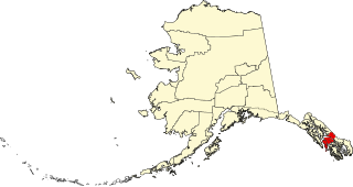
This is a list of the National Register of Historic Places listings in Petersburg, Alaska.

National Register of Historic Places listings in Nome Census Area, Alaska

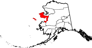
This is a list of the National Register of Historic Places listings in Nome Census Area, Alaska.

National Register of Historic Places listings in Prince of Wales–Hyder Census Area, Alaska

This is a list of the National Register of Historic Places listings in Prince of Wales–Hyder Census Area, Alaska.

National Register of Historic Places listings in Southeast Fairbanks Census Area, Alaska

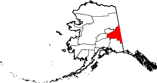
This is a list of the National Register of Historic Places listings in Southeast Fairbanks Census Area, Alaska.

National Register of Historic Places listings in Valdez–Cordova Census Area, Alaska

This is a list of the National Register of Historic Places listings in Valdez–Cordova Census Area, Alaska.

National Register of Historic Places listings in Yukon–Koyukuk Census Area, Alaska

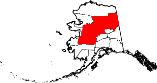
This is a list of the National Register of Historic Places listings in Yukon–Koyukuk Census Area, Alaska.

National Register of Historic Places listings in Yakutat, Alaska

This is a list of the National Register of Historic Places listings in Yakutat, Alaska.

National Register of Historic Places listings in Wrangell, Alaska

This is a list of the National Register of Historic Places listings in Wrangell, Alaska.

National Register of Historic Places listings in Sitka, Alaska

This is a list of the National Register of Historic Places listings in Sitka, Alaska.

National Register of Historic Places listings in Bristol Bay Borough, Alaska

This is a list of the National Register of Historic Places listings in Bristol Bay Borough, Alaska.

National Register of Historic Places listings in Haines Borough, Alaska

This is a list of the National Register of Historic Places listings in Haines Borough, Alaska.

National Register of Historic Places listings in Kenai Peninsula Borough, Alaska

This is a list of the National Register of Historic Places listings in Kenai Peninsula Borough, Alaska.

National Register of Historic Places listings in Ketchikan Gateway Borough, Alaska

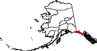
This is a list of the National Register of Historic Places listings in Ketchikan Gateway Borough, Alaska.

This is a list of the National Register of Historic Places listings in Wrangell–St. Elias National Park and Preserve.

This is a list of the National Register of Historic Places listings in Katmai National Park and Preserve.

National Register of Historic Places listings in Copper River Census Area, Alaska

This is a list of the National Register of Historic Places listings in Copper River Census Area, Alaska.

References

  1. The latitude and longitude information provided in this table was derived originally from the National Register Information System, which has been found to be fairly accurate for about 99% of listings. Some locations in this table may have been corrected to current GPS standards.
  2. National Park Service, United States Department of the Interior, "National Register of Historic Places: Weekly List Actions", retrieved December 30, 2021.
  3. 1 2 Numbers represent an alphabetical ordering by significant words. Various colorings, defined here, differentiate National Historic Landmarks and historic districts from other NRHP buildings, structures, sites or objects.
  4. "National Register Information System". National Register of Historic Places . National Park Service. April 24, 2008.
  5. The eight-digit number below each date is the number assigned to each location in the National Register Information System database, which can be viewed by clicking the number.