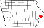
[3] Name on the Register [4] Image Date listed [5] Location City or town Description 1 E.P. Adler House E.P. Adler House July 7, 1983 (# 83002394 2104 Main St. 41°32′27″N 90°34′33″W / 41.540850°N 90.575900°W / 41.540850; -90.575900 (E.P. Adler House ) Davenport A c.1910 Colonial Revival , home of a leading businessman; Davenport Multiple Resource Area (MRA). 2 Ambrose Hall Ambrose Hall April 11, 1977 (# 77000553 518 W. Locust 41°32′20″N 90°34′51″W / 41.538889°N 90.580833°W / 41.538889; -90.580833 (Ambrose Hall ) Davenport The center section of the Second Empire building was built in 1885, and with additions, the building housed St. Ambrose College in its entirety until 1927. It continues to function as a college building. 3 American Telegraph & Telephone Co. Building American Telegraph & Telephone Co. Building July 7, 1983 (# 83002396 529 Main St. 41°31′32″N 90°34′31″W / 41.525556°N 90.575278°W / 41.525556; -90.575278 (American Telegraph & Telephone Co. Building ) Davenport Two-story Richardsonian Romanesque commercial building from 1902; Davenport MRA. 4 Argyle Flats Argyle Flats July 7, 1983 (# 83002397 732 Brady St. 41°31′39″N 90°34′28″W / 41.5275°N 90.574444°W / 41.5275; -90.574444 (Argyle Flats ) Davenport Four-story apartment building designed by Davenport architectural firm Claussen & Burrows from 1902; Davenport MRA. 5 John W. Ballard House John W. Ballard House July 7, 1983 (# 83002398 205 W. 16th St. 41°32′09″N 90°34′33″W / 41.535765°N 90.575791°W / 41.535765; -90.575791 (John W. Ballard House ) Davenport Late Victorian home from 1910; Davenport MRA. 6 Richard Benton House Richard Benton House July 7, 1983 (# 83002399 2204 and 2210 W. 3rd St. 41°31′21″N 90°36′42″W / 41.522483°N 90.611533°W / 41.522483; -90.611533 (Richard Benton House ) Davenport An Italianate and Greek Revival style residence from 1855; Davenport MRA. 7 Louis P. and Clara K. Best Residence and Auto House Louis P. and Clara K. Best Residence and Auto House May 28, 2010 (# 10000296 627 Ripley St. 41°31′36″N 90°34′41″W / 41.526594°N 90.578124°W / 41.526594; -90.578124 (Louis P. and Clara K. Best Residence and Auto House ) Davenport Mission Revival style home on the edge of the Hamburg Historic District. 8 Bethel AME Church Bethel AME Church July 7, 1983 (# 83002401 325 W. 11th St. 41°31′51″N 90°34′41″W / 41.530833°N 90.578056°W / 41.530833; -90.578056 (Bethel AME Church ) Davenport Bungalow style building that was built by members of Davenport's African-American community; Davenport MRA. 9 Brammer Grocery Store Brammer Grocery Store July 7, 1983 (# 83002404 1649 W. 3rd St. 41°31′19″N 90°36′03″W / 41.521944°N 90.600833°W / 41.521944; -90.600833 (Brammer Grocery Store ) Davenport Greek Revival style commercial building; Davenport MRA. 10 Alden Bryan House Alden Bryan House July 7, 1983 (# 83002405 2236 W. 3rd St. 41°31′21″N 90°36′45″W / 41.522523°N 90.612451°W / 41.522523; -90.612451 (Alden Bryan House ) Davenport Greek Revival style house from 1870; Davenport MRA. 11 Buchanan School Buchanan School July 7, 1983 (# 83002406 2104 W. 6th St. 41°31′33″N 90°36′32″W / 41.525913°N 90.608850°W / 41.525913; -90.608850 (Buchanan School ) Davenport Two-story Colonial Revival style building built on a raised basement. It was designed by the Davenport architectural firm of Clausen & Burrows; Davenport MRA. 12 William V. Carr House William V. Carr House July 7, 1983 (# 83002410 1531 W. 3rd St. 41°31′20″N 90°35′52″W / 41.522222°N 90.597778°W / 41.522222; -90.597778 (William V. Carr House ) Davenport House from c. 1860; Davenport MRA. 13 William Claussen House William Claussen House July 7, 1983 (# 83002412 2215 W. 2nd St. 41°31′15″N 90°36′41″W / 41.520923°N 90.611372°W / 41.520923; -90.611372 (William Claussen House ) Davenport Greek Revival syle house from 1855; Davenport MRA. 14 Clifton Clifton February 21, 1979 (# 79000940 1533 Clay St. 41°31′50″N 90°35′51″W / 41.530459°N 90.597443°W / 41.530459; -90.597443 (Clifton ) Davenport Italianate and Greek Revival style house from 1853. 15 College Square Historic District College Square Historic District November 18, 1983 (# 83003628 Roughly bounded by Brady, Main, Harrison, 11th, and 15th Sts. 41°31′56″N 90°34′33″W / 41.532222°N 90.575833°W / 41.532222; -90.575833 (College Square Historic District ) Davenport The site of two former colleges is now the location of a high school and Episcopal Cathedral campuses and a residential area; Davenport MRA. 16 Columbia Avenue Historic District Columbia Avenue Historic District November 1, 1984 (# 84000298 Roughly W. Columbia Ave. and Harrison, Ripley, and W. Hayes Sts. 41°32′49″N 90°34′40″W / 41.546944°N 90.577778°W / 41.546944; -90.577778 (Columbia Avenue Historic District ) Davenport Residential area that contains brick apartment buildings that were built between 1930 and 1939; Davenport MRA. 17 Clarissa Cook Home for the Friendless Clarissa Cook Home for the Friendless July 7, 1983 (# 83002414 2223 W. 1st St. 41°31′11″N 90°36′38″W / 41.519599°N 90.610468°W / 41.519599; -90.610468 (Clarissa Cook Home for the Friendless ) Davenport Built as a home for “destitute and indigent females” in 1884, it continues as a residence for female senior citizens; Davenport MRA. 18 Cottage at 1514 and 1516 W. Second Street Cottage at 1514 and 1516 W. Second Street July 7, 1983 (# 83002416 1514–1516 W. 2nd St. 41°31′17″N 90°35′51″W / 41.521404°N 90.597463°W / 41.521404; -90.597463 (Cottage at 1514 and 1516 W. Second Street ) Davenport Residence built c. 1850; Davenport MRA. 19 Davenport Crematorium Davenport Crematorium January 19, 1983 (# 83002418 3902 Rockingham Rd. 41°30′34″N 90°38′04″W / 41.509556°N 90.634518°W / 41.509556; -90.634518 (Davenport Crematorium ) Davenport Designed by Davenport architect Frederick G. Clausen in the Romanesque Revival style. It is located in Fairmont Cemetery. 20 Davenport Downtown Commercial Historic District Davenport Downtown Commercial Historic District September 11, 2020 (# 100005546 2nd St. to 5th St., Perry St. to Western Ave. 41°31′23″N 90°34′14″W / 41.522956°N 90.57043°W / 41.522956; -90.57043 (Davenport Downtown Commercial Historic District ) Davenport The district includes about 14 blocks of the central business district. It includes the elevated railroad tracks that runs along the north side of the downtown area. 21 Davenport Water Co. Pumping Station No. 2 Davenport Water Co. Pumping Station No. 2 April 5, 1984 (# 84001338 1416 Ripley St. 41°32′04″N 90°34′43″W / 41.534444°N 90.578611°W / 41.534444; -90.578611 (Davenport Water Co. Pumping Station No. 2 ) Davenport Italianate style industrial building constructed in 1884; Davenport MRA. 22 Marie Clare Dessaint House Marie Clare Dessaint House November 1, 1984 (# 84000300 4808 Northwest Boulevard 41°34′11″N 90°35′14″W / 41.569738°N 90.587341°W / 41.569738; -90.587341 (Marie Clare Dessaint House ) Davenport Italian Villa that was built in what was a rural area outside of Davenport in 1870; Davenport MRA 23 Arthur Ebeling House Arthur Ebeling House July 27, 1984 (# 84001397 1106 W. 15th St. 41°32′07″N 90°35′21″W / 41.535316°N 90.589265°W / 41.535316; -90.589265 (Arthur Ebeling House ) Davenport Colonial Revival style home of Davenport architect Arthur Ebeling; Davenport MRA. 24 Henry Ebeling House Henry Ebeling House July 27, 1984 (# 84001399 1623 W. 6th St. 41°31′32″N 90°35′58″W / 41.525569°N 90.599496°W / 41.525569; -90.599496 (Henry Ebeling House ) Davenport Late Victorian home from 1888; Davenport MRA. 25 Edward Edinger House Edward Edinger House July 7, 1983 (# 83002424 1018 W. 9th St. 41°31′45″N 90°35′17″W / 41.529071°N 90.588106°W / 41.529071; -90.588106 (Edward Edinger House ) Davenport Late Victorian home designed by Davenport architect Edward S. Hammatt in 1890; Davenport MRA. 26 Henry P. Fennern House Henry P. Fennern House April 5, 1984 (# 84001405 1332 W. 4th St. 41°31′25″N 90°35′37″W / 41.523611°N 90.593611°W / 41.523611; -90.593611 (Henry P. Fennern House ) Davenport Residence built in 1902; Davenport MRA. 27 Fred Finch House Fred Finch House July 7, 1983 (# 83002428 719 Main St. 41°31′39″N 90°34′31″W / 41.5275°N 90.575278°W / 41.5275; -90.575278 (Fred Finch House ) Davenport Colonial Revival home designed by Dietrich J. Harfst in 1905; Davenport MRA. 28 First Bible Missionary Church First Bible Missionary Church July 7, 1983 (# 83002429 2202 W. 4th St. 41°31′25″N 90°36′41″W / 41.523611°N 90.611389°W / 41.523611; -90.611389 (First Bible Missionary Church ) Davenport Romanesque Revival building that was built by a Congregationalist Church congregation in the early 20th century; Davenport MRA. 29 First National Bank of Davenport First National Bank of Davenport September 13, 2018 (# 100002918 1606 Brady St. 41°32′10″N 90°34′29″W / 41.536194°N 90.574667°W / 41.536194; -90.574667 (First National Bank of Davenport ) Davenport Three-story modern bank and office building completed in 1967. 30 Frick's Tavern Frick's Tavern September 9, 1974 (# 74000808 1402–1404 W. 3rd St. 41°31′21″N 90°35′40″W / 41.522512°N 90.594571°W / 41.522512; -90.594571 (Frick's Tavern ) Davenport Two-story, Italianate style commercial building from 1872. 31 D. Julius Gaspard House D. Julius Gaspard House July 7, 1983 (# 83002437 510 W. 10½ St. 41°31′49″N 90°34′49″W / 41.530315°N 90.580181°W / 41.530315; -90.580181 (D. Julius Gaspard House ) Davenport Greek Revival style house from 1880; Davenport MRA. 32 Jacob Goering House Jacob Goering House July 7, 1983 (# 83002440 721 Harrison St. 41°31′39″N 90°34′37″W / 41.5275°N 90.576944°W / 41.5275; -90.576944 (Jacob Goering House ) Davenport Greek Revival style house of an early labor organizer in Davenport; Davenport MRA. 33 Charles Grilk House Charles Grilk House July 27, 1984 (# 84001423 2026 Main St. 41°32′25″N 90°34′33″W / 41.540282°N 90.575843°W / 41.540282; -90.575843 (Charles Grilk House ) Davenport Bungalow/Craftsman and Colonial Revival style house designed in 1906 by the Davenport architectural firm of Temple, Burrows & McLane; Davenport MRA. 34 Hamburg Historic District Hamburg Historic District November 18, 1983 (# 83003656 Roughly bounded by 5th, Vine, Ripley, and 9½ Sts.; also roughly bounded by W. 5th, 6th, 7th, 8th & 9th Sts. 41°31′36″N 90°34′57″W / 41.526667°N 90.5825°W / 41.526667; -90.5825 (Hamburg Historic District ) Davenport Residential district above downtown Davenport where middle and upper class German immigrants settled in the mid to late 19th century; Davenport MRA. Second set of addresses represent a boundary adjustment approved January 17, 2017. 35 Robert Henne House Robert Henne House July 7, 1983 (# 83002445 1445 W. 3rd St. 41°31′20″N 90°35′46″W / 41.522096°N 90.596151°W / 41.522096; -90.596151 (Robert Henne House ) Davenport Greek Revival style house from 1874; Davenport MRA. 36 John Hoersch House John Hoersch House November 1, 1984 (# 84000304 716 Vine St. 41°31′38″N 90°35′16″W / 41.527192°N 90.587792°W / 41.527192; -90.587792 (John Hoersch House ) Davenport House built in 1879; Davenport MRA. 37 Samuel Hoffman, Jr., House Samuel Hoffman, Jr., House July 7, 1983 (# 83002448 2108 W. 3rd St. 41°31′21″N 90°36′35″W / 41.5225°N 90.609722°W / 41.5225; -90.609722 (Samuel Hoffman, Jr., House ) Davenport Stick/Eastlake style house from 1915; Davenport MRA. 38 Hose Station No. 6 Hose Station No. 6 July 7, 1983 (# 83002450 1410 Marquette St. 41°32′03″N 90°35′31″W / 41.534167°N 90.591944°W / 41.534167; -90.591944 (Hose Station No. 6 ) Davenport Neighborhood fire station from 1910; Davenport MRA. 39 Hose Station No. 7 Hose Station No. 7 July 7, 1983 (# 83002451 1354 W. 4th St. 41°31′25″N 90°35′39″W / 41.523639°N 90.594202°W / 41.523639; -90.594202 (Hose Station No. 7 ) Davenport Neighborhood fire station designed in the Italianate style; Davenport MRA. 40 House at 1646 W. Second Street House at 1646 W. Second Street July 7, 1983 (# 83002452 1646 W. 2nd St. 41°31′17″N 90°36′03″W / 41.521395°N 90.600728°W / 41.521395; -90.600728 (House at 1646 W. Second Street ) Davenport House built in 1865; Davenport MRA. 41 House at 2123 W. Second Street House at 2123 W. Second Street July 7, 1983 (# 83002453 2123 W. 2nd St. 41°31′15″N 90°36′36″W / 41.520935°N 90.610055°W / 41.520935; -90.610055 (House at 2123 W. Second Street ) Davenport Greek Revival style house from 1855; Davenport MRA. 42 House at 2212 W. River Drive House at 2212 W. River Drive November 1, 1984 (# 84000309 2212 W. River Dr. 41°30′35″N 90°36′25″W / 41.509777°N 90.606948°W / 41.509777; -90.606948 (House at 2212 W. River Drive ) Davenport House built in 1855; Davenport MRA. 43 Theodore Jansen House Theodore Jansen House July 7, 1983 (# 83002455 922 Myrtle St. 41°31′46″N 90°35′22″W / 41.529545°N 90.589422°W / 41.529545; -90.589422 (Theodore Jansen House ) Davenport Queen Anne style house from 1888; Davenport MRA. 44 Henry Kahl House Henry Kahl House July 7, 1983 (# 83002457 1101 W. 9th St. 41°31′41″N 90°35′22″W / 41.528164°N 90.589339°W / 41.528164; -90.589339 (Henry Kahl House ) Davenport Mission/Spanish Revival style home designed by Davenport architect Arthur Ebeling in 1920. It became part of the Kahl Home for the Aged and Infirm; Davenport MRA. 45 Albert Kiene House Albert Kiene House July 27, 1984 (# 84001450 1321 W. 8th St. 41°31′39″N 90°35′37″W / 41.527627°N 90.593478°W / 41.527627; -90.593478 (Albert Kiene House ) Davenport Second Empire style home from 1881; Davenport MRA. 46 George Klindt House George Klindt House July 7, 1983 (# 83002459 902 Marquette St. 41°31′44″N 90°35′30″W / 41.528889°N 90.591667°W / 41.528889; -90.591667 (George Klindt House ) Davenport Second Empire style home; Davenport MRA. 47 Henry Klindt House Henry Klindt House July 27, 1984 (# 84001454 834 Marquette St. 41°31′43″N 90°35′29″W / 41.528688°N 90.591519°W / 41.528688; -90.591519 (Henry Klindt House ) Davenport Queen Anne style home from 1890; Davenport MRA. 48 Koch Drug Store Koch Drug Store July 27, 1984 (# 84001457 1501 Harrison St. 41°32′06″N 90°34′37″W / 41.535016°N 90.577075°W / 41.535016; -90.577075 (Koch Drug Store ) Davenport Late Victorian commercial building from 1881; Davenport MRA. 49 Nicholas Koester Building Nicholas Koester Building July 7, 1983 (# 83002461 1353 W. 3rd St. 41°31′20″N 90°35′39″W / 41.522142°N 90.594225°W / 41.522142; -90.594225 (Nicholas Koester Building ) Davenport Italianate style commercial building from 1890; Davenport MRA. 50 Gustov C. Lerch House Gustov C. Lerch House July 7, 1983 (# 83002463 2222 W. 4th St. 41°31′25″N 90°36′44″W / 41.523611°N 90.612222°W / 41.523611; -90.612222 (Gustov C. Lerch House ) Davenport Shingle Style, Colonial Revival house from 1905; Davenport MRA. 51 John Lippincott House John Lippincott House July 7, 1983 (# 83004527 2122 W. 3rd St. 41°31′21″N 90°36′36″W / 41.522494°N 90.61°W / 41.522494; -90.61 (John Lippincott House ) Davenport Greek Revival style house from 1870; Davenport MRA. 52 Littig Brothers/Mengel & Klindt/Eagle Brewery Littig Brothers/Mengel & Klindt/Eagle Brewery July 7, 1983 (# 83002464 1235 W. 5th St. 41°31′28″N 90°35′31″W / 41.524444°N 90.591944°W / 41.524444; -90.591944 (Littig Brothers/Mengel & Klindt/Eagle Brewery ) Davenport One of five breweries built in Davenport in the late 19th century; Davenport MRA. 53 John Littig House John Littig House November 1, 1984 (# 84000310 6035 Northwest Boulevard 41°34′59″N 90°35′51″W / 41.583056°N 90.5975°W / 41.583056; -90.5975 (John Littig House ) Davenport A Shingle Style and Gothic Revival residence that was built in 1867; Davenport MRA. 54 John Lueschen House John Lueschen House July 27, 1984 (# 84001468 1628–1632 Washington St. 41°32′12″N 90°35′48″W / 41.536661°N 90.596531°W / 41.536661; -90.596531 (John Lueschen House ) Davenport Greek Revival style house from 1865; Davenport MRA. 55 August F. Martzahn House August F. Martzahn House July 7, 1983 (# 83002466 2303 W. 3rd St. 41°31′19″N 90°36′48″W / 41.522015°N 90.613332°W / 41.522015; -90.613332 (August F. Martzahn House ) Davenport A house built in a combination of the Prairie School and Bungalow/Craftsman styles in 1911; Davenport MRA. 56 Marycrest College Historic District Marycrest College Historic District April 14, 2004 (# 04000341 Portions of the 1500 and 1600 blocks of W. 12th St. 41°31′52″N 90°35′55″W / 41.531049°N 90.598555°W / 41.531049; -90.598555 (Marycrest College Historic District ) Davenport Former Catholic college campus operated by the Congregation of the Humility of Mary. It is now a housing complex for senior citizens. 57 Patrick F. McCarthy House Patrick F. McCarthy House July 27, 1984 (# 84001471 942 Marquette St. 41°31′46″N 90°35′31″W / 41.529444°N 90.591895°W / 41.529444; -90.591895 (Patrick F. McCarthy House ) Davenport Tudor Revival style house from 1905; Davenport MRA. 58 Joseph S. McHarg House Joseph S. McHarg House April 9, 1985 (# 85000775 5905 Chapel Hill Rd. 41°29′27″N 90°39′37″W / 41.490777°N 90.660356°W / 41.490777; -90.660356 (Joseph S. McHarg House ) Davenport Greek Revival style house from 1870; Davenport MRA. 59 McManus House McManus House July 7, 1983 (# 83002469 2320 Telegraph Rd. 41°31′27″N 90°36′48″W / 41.524167°N 90.613333°W / 41.524167; -90.613333 (McManus House ) Davenport Italianate and Greek Revival style house from 1855: Davenport MRA. 60 Meadly House Meadly House July 27, 1984 (# 84001476 1425 W. 10th St. 41°31′45″N 90°35′43″W / 41.529282°N 90.595348°W / 41.529282; -90.595348 (Meadly House ) Davenport Second Empire style house from 1881; Davenport MRA. 61 Dr. George McLelland Middleton House and Garage Dr. George McLelland Middleton House and Garage November 10, 1982 (# 82001549 1221 Scott St. 41°31′56″N 90°34′47″W / 41.532222°N 90.579722°W / 41.532222; -90.579722 (Dr. George McLelland Middleton House and Garage ) Davenport Classical Revival style house designed by Davenport architect Fritz G. Clausen in 1903. 62 Miller Building Miller Building July 7, 1983 (# 83002471 724 Harrison St. 41°31′38″N 90°34′38″W / 41.527222°N 90.577222°W / 41.527222; -90.577222 (Miller Building ) Davenport Late Victorian commercial building; Davenport MRA. 63 Severin Miller House Severin Miller House July 7, 1983 (# 83002473 2200 Telegraph Rd. 41°31′32″N 90°36′38″W / 41.525556°N 90.610556°W / 41.525556; -90.610556 (Severin Miller House ) Davenport Second Empire style house from 1868; Davenport MRA. 64 Daniel T. Newcome Double House Daniel T. Newcome Double House July 7, 1983 (# 83002475 722–724 Brady St. 41°31′39″N 90°34′28″W / 41.527505°N 90.574358°W / 41.527505; -90.574358 (Daniel T. Newcome Double House ) Davenport Second Empire residential building by Davenport builder T.W. McClelland; Davenport MRA. 65 Northwest Davenport Savings Bank Northwest Davenport Savings Bank July 27, 1984 (# 84001491 1529 Washington St. 41°32′08″N 90°35′45″W / 41.535556°N 90.595833°W / 41.535556; -90.595833 (Northwest Davenport Savings Bank ) Davenport Classical Revival commercial building from 1912; Davenport MRA. 66 Northwest Davenport Turner Society Hall Northwest Davenport Turner Society Hall July 10, 1979 (# 79000941 1602 Washington St. 41°32′10″N 90°35′48″W / 41.535989°N 90.596701°W / 41.535989; -90.596701 (Northwest Davenport Turner Society Hall ) Davenport Built in 1882. One of three Davenport Turnvereins . 67 Henry Pahl House Henry Pahl House July 7, 1983 (# 83002480 1946 W. 3rd St. 41°31′21″N 90°36′25″W / 41.5225°N 90.606944°W / 41.5225; -90.606944 (Henry Pahl House ) Davenport Greek Revival style house from 1880; Davenport MRA. 68 B.J. Palmer House B.J. Palmer House July 27, 1984 (# 84001497 808 Brady St. 41°31′43″N 90°34′28″W / 41.528521°N 90.574325°W / 41.528521; -90.574325 (B.J. Palmer House ) Davenport Second Empire house built in 1874. It became the home of B.J. Palmer, who along with his father, developed the practice of chiropractic; Davenport MRA. 69 Peter J. Paulsen House Peter J. Paulsen House July 7, 1983 (# 83002481 705 Main St. 41°31′37″N 90°34′31″W / 41.527080°N 90.575263°W / 41.527080; -90.575263 (Peter J. Paulsen House ) Davenport Queen Anne style house built in 1895; Davenport MRA. 70 Henry Paustian House Henry Paustian House July 7, 1983 (# 83002482 1226 W. 6th St. 41°31′33″N 90°35′30″W / 41.525833°N 90.591667°W / 41.525833; -90.591667 (Henry Paustian House ) Davenport Early example of a stone house built in the city of Davenport; Davenport MRA. 71 Peters' Barber Shop Peters' Barber Shop April 5, 1984 (# 84001498 1352 W. 3rd St. 41°31′21″N 90°35′39″W / 41.522501°N 90.594132°W / 41.522501; -90.594132 (Peters' Barber Shop ) Davenport Single-story commercial building built in 1905; Davenport MRA. 72 J.C. Peters House J.C. Peters House July 27, 1984 (# 84001500 1339 W. 13th St. 41°31′57″N 90°35′35″W / 41.532492°N 90.593149°W / 41.532492; -90.593149 (J.C. Peters House ) Davenport Greek Revival style house built in 1865; Davenport MRA. 73 Max Petersen House Max Petersen House December 25, 1979 (# 79000942 1607 W. 12th St. 41°31′50″N 90°35′57″W / 41.530556°N 90.599167°W / 41.530556; -90.599167 (Max Petersen House ) Davenport Queen Anne style house designed by Davenport architect Fredrick G. Clausen in 1888. 74 Frank Picklum House Frank Picklum House July 27, 1984 (# 84001515 1340 W. 7th St. 41°31′37″N 90°35′39″W / 41.526955°N 90.594139°W / 41.526955; -90.594139 (Frank Picklum House ) Davenport House built in 1881;Davenport MRA. 75 Joachim Plambeck House Joachim Plambeck House July 27, 1984 (# 84001516 1421 W. 14th St. 41°32′01″N 90°35′41″W / 41.533544°N 90.594842°W / 41.533544; -90.594842 (Joachim Plambeck House ) Davenport Late Victorian house from 1888; Davenport MRA. 76 Elizabeth Pohlmann House Elizabeth Pohlmann House July 27, 1984 (# 84001518 1403 W. 13th St. 41°31′57″N 90°35′39″W / 41.532469°N 90.594214°W / 41.532469; -90.594214 (Elizabeth Pohlmann House ) Davenport Queen Anne style house from 1896; Davenport MRA. 77 Henry Pohlmann House Henry Pohlmann House July 27, 1984 (# 84001520 1204 W. 13th St. 41°31′59″N 90°35′26″W / 41.533056°N 90.590556°W / 41.533056; -90.590556 (Henry Pohlmann House ) Davenport House built in 1885; Davenport MRA. 78 F.J. Raible House F.J. Raible House November 28, 1983 (# 83003683 1537 W. 3rd St. 41°31′19″N 90°35′53″W / 41.521944°N 90.598056°W / 41.521944; -90.598056 (F.J. Raible House ) Davenport Greek Revival style house built in 1870; Davenport MRA. 79 Ranzow-Sander House Ranzow-Sander House July 7, 1983 (# 83002489 2128 W. 3rd St. 41°31′21″N 90°36′37″W / 41.5225°N 90.610278°W / 41.5225; -90.610278 (Ranzow-Sander House ) Davenport Queen Anne style house from 1881; Davenport MRA. 80 Jacob Raphael Building Jacob Raphael Building July 7, 1983 (# 83002490 628–630 Harrison St. 41°31′35″N 90°34′39″W / 41.526389°N 90.5775°W / 41.526389; -90.5775 (Jacob Raphael Building ) Davenport Commercial building from 1875 that housed a cigar manufacturer; Davenport MRA. 81 Riverview Terrace Historic District Riverview Terrace Historic District November 1, 1984 (# 84000339 Roughly Riverview Terr. and Clay and Marquette Sts. 41°31′49″N 90°35′43″W / 41.530278°N 90.595278°W / 41.530278; -90.595278 (Riverview Terrace Historic District ) Davenport Residential area consisting of 21 contributing buildings built around a park that overlooks the city's west end; Davenport MRA. 82 Royal Neighbors of America National Home Historic District Royal Neighbors of America National Home Historic District June 2, 2015 (# 15000294 4760 Rockingham Rd. 41°30′15″N 90°38′48″W / 41.5042°N 90.6466°W / 41.5042; -90.6466 (Royal Neighbors of America National Home Historic District ) Davenport A Georgian Revival style residential facility built in 1931. It was operated by the Royal Neighbors of America, a fraternal benefit society, from 1931 to 2004. 83 St. Joseph's Catholic Church St. Joseph's Catholic Church July 7, 1983 (# 83002510 W. 6th and Marquette Sts. 41°31′33″N 90°35′26″W / 41.525865°N 90.590568°W / 41.525865; -90.590568 (St. Joseph's Catholic Church ) Davenport The parish was founded in 1855 as St. Kunigunda to serve the city’s German community. The cornerstone for the present church was laid in 1881 when the parish name was changed to St. Joseph. The building currently houses Grace Fellowship Church; Davenport MRA. 84 St. Luke's Hospital St. Luke's Hospital July 7, 1983 (# 83002511 121 W. 8th St. 41°31′41″N 90°34′30″W / 41.527936°N 90.574985°W / 41.527936; -90.574985 (St. Luke's Hospital ) Davenport Italianate style residence built by Daniel Newcomb that housed St. Luke’s Hospital when it was begun by the Episcopal Diocese of Iowa in 1892; Davenport MRA. 85 St. Mary's Academy St. Mary's Academy July 27, 1984 (# 84001556 1334 W. 8th St. 41°31′41″N 90°35′39″W / 41.528077°N 90.594038°W / 41.528077; -90.594038 (St. Mary's Academy ) Davenport Romanesque Revival parochial school building built in 1888. It later became a home for women and is now an apartment building; Davenport MRA. 86 St. Mary's Roman Catholic Church Complex St. Mary's Roman Catholic Church Complex April 5, 1984 (# 84001558 516, 519, 522, and 525 Fillmore Sts. 41°31′32″N 90°35′41″W / 41.525436°N 90.594739°W / 41.525436; -90.594739 (St. Mary's Roman Catholic Church Complex ) Davenport Church, rectory, school and convent from St. Mary's parish. The buildings were built in the Romanesque and Colonial Revival styles; Davenport MRA. 87 St. Paul's English Lutheran Church St. Paul's English Lutheran Church July 7, 1983 (# 83002512 1402 Main St. 41°32′03″N 90°34′33″W / 41.534125°N 90.575901°W / 41.534125; -90.575901 (St. Paul's English Lutheran Church ) Davenport Gothic Revival church building from 1902; Davenport MRA. 88 Richard Schebler House Richard Schebler House July 7, 1983 (# 83002496 1217 W. 7th St. 41°31′36″N 90°35′30″W / 41.526630°N 90.591669°W / 41.526630; -90.591669 (Richard Schebler House ) Davenport Greek Revival house built in 1876; Davenport MRA. 89 F. Jacob Schmidt House F. Jacob Schmidt House July 7, 1983 (# 83002499 2143 and 2147 W. 5th St. 41°31′27″N 90°36′39″W / 41.524243°N 90.610870°W / 41.524243; -90.610870 (F. Jacob Schmidt House ) Davenport Queen Anne style house built in 1890; Davenport MRA. 90 School Number 6 School Number 6 October 6, 2011 (# 11000722 1420 W. 16th St. 41°32′10″N 90°35′41″W / 41.536115°N 90.594811°W / 41.536115; -90.594811 (School Number 6 ) Davenport 1903 former school building that is being renovated into apartment units. Also known as Jackson School. 91 John C. Schricker House John C. Schricker House July 7, 1983 (# 83002500 1446 Clay St. 41°31′50″N 90°35′44″W / 41.530556°N 90.595556°W / 41.530556; -90.595556 (John C. Schricker House ) Davenport Colonial Revival style house designed by Davenport architect Gustav Hansen in 1896; Davenport MRA 92 John Schricker House John Schricker House April 9, 1985 (# 85000776 5418 Chapel Hill Rd. 41°29′21″N 90°39′07″W / 41.489167°N 90.651944°W / 41.489167; -90.651944 (John Schricker House ) Davenport House designed by the Davenport architectural firm of Clausen & Clausen in 1910; Davenport MRA. 93 Schroeder Bros. Meat Market Schroeder Bros. Meat Market July 7, 1983 (# 83002501 2146 W. 3rd St. 41°31′21″N 90°36′39″W / 41.5225°N 90.610833°W / 41.5225; -90.610833 (Schroeder Bros. Meat Market ) Davenport Commercial Vernacular style building built in 1905; Davenport MRA. 94 Rudolph H. Sitz Building Rudolph H. Sitz Building July 7, 1983 (# 83002506 2202 W. 3rd St. 41°31′21″N 90°36′41″W / 41.5225°N 90.611389°W / 41.5225; -90.611389 (Rudolph H. Sitz Building ) Davenport Mission/Spanish Revival style commercial building; Davenport MRA. 95 Alvord I. Smith House Alvord I. Smith House July 7, 1983 (# 83002507 2318 W. 3rd St. 41°31′21″N 90°36′50″W / 41.5225°N 90.613889°W / 41.5225; -90.613889 (Alvord I. Smith House ) Davenport Italianate style house from 1865; Davenport MRA. 96 Dr. Kuno Struck House Dr. Kuno Struck House July 27, 1984 (# 84001567 1645 W. 12th St. 41°31′50″N 90°36′01″W / 41.530556°N 90.600278°W / 41.530556; -90.600278 (Dr. Kuno Struck House ) Davenport Tudor Revival style house designed by the Davenport architectural firm of Clausen & Kruse in 1911; Davenport MRA. 97 Taylor School Taylor School July 7, 1983 (# 83002516 1400 Warren St. 41°32′05″N 90°35′10″W / 41.534722°N 90.586111°W / 41.534722; -90.586111 (Taylor School ) Davenport Former school building designed in the Colonial Revival style by the Davenport architectural firm of Clausen & Burrows; Davenport MRA. 98 Lambert Tevoet House Lambert Tevoet House July 7, 1983 (# 83002518 2017 W. 2nd St. 41°31′16″N 90°36′28″W / 41.521010°N 90.607901°W / 41.521010; -90.607901 (Lambert Tevoet House ) Davenport Greek Revival style house from 1870; Davenport MRA. 99 Trinity Episcopal Cathedral Trinity Episcopal Cathedral December 24, 1974 (# 74000811 121 W. 12th St. 41°31′52″N 90°34′28″W / 41.531111°N 90.574444°W / 41.531111; -90.574444 (Trinity Episcopal Cathedral ) Davenport Only the second church built as a cathedral in the Protestant Episcopal Church. It was designed by New York architect Edward Tuckerman Potter in 1867 and opened in 1873. The tower, part of the original design, was completed in 1998. 100 Union Electric Telephone & Telegraph Union Electric Telephone & Telegraph July 7, 1983 (# 83002519 602 Harrison St. 41°31′33″N 90°34′39″W / 41.525833°N 90.5775°W / 41.525833; -90.5775 (Union Electric Telephone & Telegraph ) Davenport Classic Revival building that was constructed to house a now defunct telephone and telegraph company. It remains a commercial building; Davenport MRA. 101 Claus Untiedt House Claus Untiedt House July 27, 1984 (# 84001577 1429 W. 14th St. 41°32′04″N 90°35′42″W / 41.534444°N 90.595°W / 41.534444; -90.595 (Claus Untiedt House ) Davenport Late Victorian house built in 1890; Davenport MRA. 102 Vander Veer Park Historic District Vander Veer Park Historic District April 9, 1985 (# 85000784 Roughly bounded by Temple Lane, W. Central Park Ave., and Brady, High, and Harrison Sts. 41°32′35″N 90°34′28″W / 41.543056°N 90.574444°W / 41.543056; -90.574444 (Vander Veer Park Historic District ) Davenport Established as Central Park on the former fair grounds, the botanical park and its surrounding neighborhoods make up the district; Davenport MRA. Extends into East Davenport . 103 Walter-Gimble House Walter-Gimble House July 7, 1983 (# 83002522 1232 W. 6th St. 41°31′33″N 90°35′31″W / 41.525833°N 90.591944°W / 41.525833; -90.591944 (Walter-Gimble House ) Davenport House that was built in 1875; Davenport MRA. 104 Washington Flats Washington Flats July 27, 1984 (# 84001584 1415–1431 Washington St. 41°32′04″N 90°35′45″W / 41.534444°N 90.595833°W / 41.534444; -90.595833 (Washington Flats ) Davenport Two-story brick apartment building from 1905; Davenport MRA. 105 Washington Gardens Washington Gardens July 27, 1984 (# 84001585 1301 W. 13th St. 41°31′57″N 90°35′30″W / 41.5325°N 90.591667°W / 41.5325; -90.591667 (Washington Gardens ) Davenport Italianate commercial building from 1885 that has housed restaurants and taverns over the years; Davenport MRA. 106 Werthman Grocery Werthman Grocery July 27, 1984 (# 84001588 1402 W. 7th St. 41°31′37″N 90°35′40″W / 41.526902°N 90.594500°W / 41.526902; -90.594500 (Werthman Grocery ) Davenport Commercial building from 1900; Davenport MRA. 107 Westphal-Schmidt House Westphal-Schmidt House July 27, 1984 (# 84001591 406 S. Fairmount St. 41°30′54″N 90°37′51″W / 41.515093°N 90.630804°W / 41.515093; -90.630804 (Westphal-Schmidt House ) Davenport Italianate style house from 1857; Davenport MRA. 108 Thomas C. Wilkinson House Thomas C. Wilkinson House July 27, 1984 (# 84001592 117 McManus St. 41°31′14″N 90°37′11″W / 41.520556°N 90.619722°W / 41.520556; -90.619722 (Thomas C. Wilkinson House ) Davenport Italian Villa style house built c. 1860; Davenport MRA. 109 Wolters Filling Station Wolters Filling Station July 27, 1984 (# 84001595 1229 Washington St. 41°31′57″N 90°35′46″W / 41.532556°N 90.596126°W / 41.532556; -90.596126 (Wolters Filling Station ) Davenport Small commercial structure in old Northwest Davenport; Davenport MRA. 110 Zoller Bros-Independent Malting Co. Zoller Bros-Independent Malting Co. July 7, 1983 (# 83002527 1801 W. 3rd St. 41°31′19″N 90°36′12″W / 41.521944°N 90.603320°W / 41.521944; -90.603320 (Zoller Bros-Independent Malting Co. ) Davenport One of five breweries that were established in Davenport in the 19th century; Davenport MRA.