Davenport is a city in and the county seat of Scott County, Iowa, United States. It is located along the Mississippi River on the eastern border of the state, and is the largest of the Quad Cities, a metropolitan area with a population estimate of 382,630 and a CSA population of 474,226; it is the 90th largest CSA in the nation. Davenport was founded on May 14, 1836 by Antoine Le Claire and was named for his friend George Davenport, a former English sailor who served in the U.S. Army during the War of 1812, served as a supplier Fort Armstrong, worked as a fur trader with the American Fur Company, and was appointed a quartermaster with the rank of colonel during the Black Hawk War. According to the 2010 census, the city had a population of 99,685. The city appealed this figure, arguing that the Census Bureau missed a section of residents, and that its total population was more than 100,000. The Census Bureau estimated Davenport's 2019 population to be 101,590.
Davenport, Iowa, was part of the Louisiana Purchase. In 1814, during the War of 1812 the British military, along with the Saux and Fox Indian tribes fought against the Americans near Davenport. In August, Major Zachary Taylor, later President, fought a battle east of what is now Credit Island Park, in Davenport. An outpost was set up at Fort Armstrong and George Davenport and Antonie LeClaire were stationed there.

The Prospect Park Historic District in Davenport, Iowa, United States, is a historic district that was listed on the National Register of Historic Places in 1984. In its 23.2-acre (9.4 ha) area, it included 23 contributing buildings in 1984. The Prospect Park hill was listed on the Davenport Register of Historic Properties in 1993.

The McClellan Heights Historic District is a 188.2-acre (76.2 ha) historic district in Davenport, Iowa, United States. It was listed on the National Register of Historic Places in 1984, at which time it included 354 buildings deemed to contribute to the historic character of the area.

The Crescent Warehouse Historic District is a 10.5-acre (4.2 ha) historic district in Downtown Davenport, Iowa, United States. The district is a collection of multi-story brick structures that formerly housed warehouses and factories. Most of the buildings have been converted into loft apartments. The district was listed on the National Register of Historic Places in 2003.

St. Katherine's Historic District is located on the east side Davenport, Iowa, United States and is listed on the National Register of Historic Places. It is the location of two mansions built by two lumber barons until it became the campus of an Episcopal girls' school named St. Katharine's Hall and later as St. Katharine's School. The name was altered to St. Katharine-St. Mark's School when it became coeducational. It is currently the location of a senior living facility called St. Katherine's Living Center.

The Hibernia Hall, also known as the Hibernian Hall, is a Romanesque Revival building located in downtown Davenport, Iowa, United States. It is located on the east side of Brady Street, near the middle of the block. The Hibernian Hall was individually listed on the National Register of Historic Places in 1983.In 2020 it was included as contributing property in the Davenport Downtown Commercial Historic District.
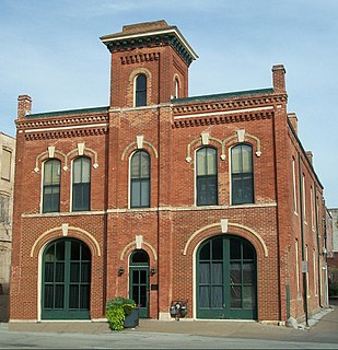
The Hose Station No. 1 is a historic building located in downtown Davenport, Iowa, United States. It was listed on the National Register of Historic Places in 1983 and on the Davenport Register of Historic Properties in 1999. In 2019 it was included as a contributing property in the Davenport Motor Row and Industrial Historic District.

The Central Fire Station is located in downtown Davenport, Iowa, United States and serves as the headquarters of the Davenport Fire Department, as well as the downtown fire station. Built from 1901 to 1902, the original building is the oldest active fire station west of the Mississippi River. It was individually listed on the National Register of Historic Places in 1982. In 2020 it was included as a contributing property in the Davenport Downtown Commercial Historic District.
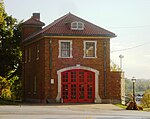
The Hose Station No. 7 is located along a busy thoroughfare in a light industrial area of the west end of Davenport, Iowa, United States. It was listed on the National Register of Historic Places in 1983.

The Cork Hill District is a nationally recognized historic district located in Davenport, Iowa, United States. It was listed on the National Register of Historic Places in 1984. The historic district covers 18.7-acre (7.6 ha) and stretches from the campus of Palmer College of Chiropractic on the west to the Sacred Heart Cathedral Complex on the east. It is the western half of a neighborhood of the same name. When listed, the district included 12 contributing buildings. It includes Greek Revival, Italianate, and Victorian architecture. The district was covered in a 1982 study of Davenport Multiple Resource Area and/or its 1983 follow-on.

The Burtis–Kimball House Hotel and the Burtis Opera House were located in downtown Davenport, Iowa, United States. The hotel was listed on the National Register of Historic Places in 1979. It has since been torn down and it was delisted from the National Register in 2008. The theatre building has been significantly altered since a fire in the 1920s. Both, however, remain important to the history of the city of Davenport.

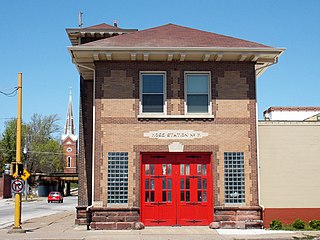
Davenport Hose Station No. 3 is located in a commercial area on the east side of Davenport, Iowa, United States. It has been listed on the National Register of Historic Places since 1984. The building is one of two historic former fire stations on the east side that are still in existence. The other one is Hose Station No. 4 in the Village of East Davenport.
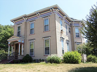
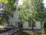
The James E. Lindsay House is a historic building located on the east side of Davenport, Iowa, United States. It has been listed on the National Register of Historic Places since 1984.

This is intended to be a complete list of the properties and districts on the National Register of Historic Places in Downtown Davenport, Iowa, United States. Downtown Davenport is defined as being all of the city south of 5th Street from Marquette Street east to the intersection of River Drive and East 4th Street. The locations of National Register properties and districts may be seen in an online map.

Hose Station No. 4 is located in the Village of East Davenport in Davenport, Iowa, United States. It is a contributing property of the Davenport Village Historic District that has been listed on the National Register of Historic Places since 1980. The fire station was individually listed on the Davenport Register of Historic Properties in 1993. It is one of two old fire stations on the east side of the city that are still in existence. The other one is Hose Station No. 3. The building sits adjacent to Lindsay Park and now houses the International Fire Museum.

Lindsay Park is a 31-acre (0.13 km2) park. located in the Village of East Davenport in Davenport, Iowa, United States. The lower park is a contributing property of the Davenport Village Historic District that has been listed on the National Register of Historic Places since 1980, and the upper park is part of the McClellan Heights Historic District which was listed on the national register in 1984. The whole park was individually listed on the Davenport Register of Historic Properties in 1998. Lindsay Park is owned by the city of Davenport and features a playground, baseball diamonds and views of the Mississippi River, which is immediately to the south of the park. There is a group of architectural sculptures along the Riverfront Parkway, of which Lindsay Park is a part. The park also hosts the annual Riverssance Festival of Fine Art.
Camp McClellan is a former Union Army camp in the U.S. state of Iowa that was established in Davenport in August 1861 after the outbreak of the American Civil War. The camp was the training grounds for recruits and a hospital for the wounded. In 1863 it became a prison camp called Camp Kearney for members of the Sioux, or Dakota, tribe that were involved in raids in Minnesota. The camp was decommissioned after the release of the prisoners in 1866.

Frederick Denkmann was an American lumber baron based in Rock Island, Illinois. He teamed up with his brother-in-law Friedrich Weyerhäuser and formed Weyerhäuser-Denkmann Lumber Company.

The Davenport Downtown Commercial Historic District is a nationally recognized historic district located in the central business district of Davenport, Iowa, United States. It was listed on the National Register of Historic Places in 2020. At the time of its nomination it consisted of 43 resources, which included 33 contributing buildings, one contributing structure, and nine non-contributing buildings. In addition, the district also contains 33 buildings that are individually listed on the National Register. This historic district is bordered by four other districts: the Crescent Warehouse Historic District and the Davenport Motor Row and Industrial Historic District on the east, the Hamburg Historic District to the northwest, and the West Third Street Historic District on the west.