National parks of Wales

Last updated

The three national parks:
  1. Snowdonia (Eryri)
  2. Brecon Beacons
    (Bannau Brycheiniog)
  3. Pembrokeshire Coast

The national parks of Wales (Welsh : parciau cenedlaethol Cymru) are managed areas of outstanding landscape in Wales, United Kingdom where some forms of development are restricted to preserve the landscape and natural environment. Together, they cover 20% of the land surface of Wales and have a resident population of over 80,000 people. Each National Park Authority is a free-standing body within the local government framework.

Contents

At present, Wales has three national parks: Snowdonia (Eryri), created in 1951, Pembrokeshire Coast, created in 1952, and the Brecon Beacons (Bannau Brycheiniog), created in 1957, as well as five areas of outstanding natural beauty (AONB), which form some of the protected areas of Wales. [1] One of the AONBs, the Clwydian Range and Dee Valley has been proposed to be replaced by a new national park, which would become Wales' fourth national park.

The three national park authorities work in partnership as 'National Parks Wales' (NPW) which promotes their purposes and interests. NPW identifies issues of joint interest and a way of agreeing outputs. Information and experiences are shared by NPW between various people concerned with the three National Parks. [2]

Land within these areas remains largely in private ownership; these parks are not truly national parks according to the internationally accepted standard of the IUCN [3] but they are areas of outstanding landscape where certain types of activity are slightly more restricted. National Parks are "national" as they are considered to be of special value to the whole nation.

The Environment Act 1995 notes that the National Parks of Wales have two purposes:

Administration

Following the Environment Act 1995, each national park has been managed by its own national park authority, a special purpose local authority, since April 1997. [5]

Around half the members of each national park authority are appointees from the principal local authorities covered by the park; the remainder are appointed by the Senedd, some to represent the community councils, others selected to represent the "national interest". [6] The National Park Authority is also the sole local planning authority for the park. Together the national parks are visited by an estimated 12 million people each year and almost three quarters of the population of Wales visit the Parks each year. [4]

The parks

Snowdonia (Eryri)

Llyn Llydaw from Crib Goch 2.jpg

Formed in 1951, Snowdonia (Eryri) is the largest national park in Wales, and includes the highest mountain in Ireland, England and Wales, and Wales' largest natural lake. The area is steeped in culture and local history, where more than half its population speak Welsh [7] Fossil shell fragments on the summit of Snowdon date from over 500 million years ago and the ancient ‘Harlech Dome’ of which Snowdon and Cadair Idris form the northern and southern extents respectively, was created in the Cambrian Period before the volcanoes erupted. The more recent Ice Age glaciers were at their peak 18,000 years ago in Snowdonia and formed the distinctive U-shaped valleys including those at Llanberis and Nant Gwynant in the north and Tal-y-llyn Lake in the south. [8]

The park is governed by the Eryri National Park Authority (Snowdonia National Park Authority), which is made up of local government and Welsh Government representatives. Its main offices are at Penrhyndeudraeth.

Pembrokeshire Coast

Pembrokeshire Cast path near Pwllgwaelod.jpg

Formed in 1952, this is the only national park recognised primarily for its coastline; it covers almost all the Pembrokeshire Coast, every offshore island, the Daugleddau estuary and large areas of the Preseli Hills and the Gwaun Valley. It is an ecologically rich area recognised as of international importance for a wide range of high quality habitats and rare species. The park contains thirteen Special Areas of Conservation, five Special Protection Areas, one marine nature reserves and seven national nature reserves as well as sixty Sites of Special Scientific Interest. [9] The park also contains a wealth of human history and culture, including the UK's smallest city, St Davids and Iron Age forts. Within the park there are also a total of sixty geological conservation sites ranging from small roadside quarries and isolated crags on hilltops to many kilometres of coastline. [9]

The Park is managed by Pembrokeshire Coast National Park Authority, which has around 130 staff and a committee of 18 members. [9] The Chief Executive is Tegryn Jones. [10] The Authority also manages the entire length of the Pembrokeshire Coast Path, a 186-mile (299 km) national trail which lies almost entirely within the Pembrokeshire Coast National Park. More than 26,000 people live within the park. 58.6% of the population could speak Welsh in 2011. [11]

Brecon Beacons (Bannau Brycheiniog)

Brecon beacons arp.jpg

The last of the three national parks, formed in 1957 as the Brecon Beacons National Park and retitled to its Welsh name in 2023, [12] [13] the park straddles the divide between rural mid Wales and industrial South Wales. It stretches from Llandeilo in the west to Hay-on-Wye in the northeast and Pontypool in the southeast, covering 519 square miles (1,340 km2) and encompassing four main regions – the Black Mountain in the west, Fforest Fawr and the Brecon Beacons in the centre, and the Black Mountains in the east, where the highest point is Waun Fach 811 metres (2,661 feet).

It is formed from sedimentary rocks from the mid Ordovician through to the late Carboniferous though it is the Devonian Old Red Sandstone which is the rock most identified with the park, since it forms the larger part of the different mountain massifs including South Wales' highest point Pen y Fan at 886m. Like many other upland national parks it is glacial activity during the Quaternary ice ages which is responsible for many of the well-known landforms. The west of the park is also designated as Fforest Fawr Geopark in recognition of its geological interest, and includes Waterfall Country. A number of former tramroads and the Monmouthshire and Brecon Canal running down the Usk valley dating from the Industrial Revolution now serve as recreational facilities. [14]

The Bannau Brycheiniog National Park Authority (Brecon Beacons National Park Authority) is a special purpose local authority with wide-ranging responsibilities for the conservation and enhancement of the landscape and the promotion of its enjoyment by the public, and in particular exercises planning functions across the designated area of the park.

List of national parks

NamePhotoCounty/iesDate formed [15] Area
Snowdonia (Eryri) Llyn Llydaw from Crib Goch 2.jpg
Gwynedd, Conwy
52°54′N3°51′W / 52.900°N 3.850°W / 52.900; -3.850
18 October 19512,142 square kilometres (827.0 sq mi)
Pembrokeshire Coast
(Welsh: Arfordir Penfro)
Marloes peninsula, Pembrokeshire coast, Wales, UK.JPG
Pembrokeshire
51°50′N5°05′W / 51.833°N 5.083°W / 51.833; -5.083
29 February 1952620 square kilometres (239.4 sq mi)
Brecon Beacons
(Bannau Brycheiniog)
Brecon beacons arp.jpg
Blaenau Gwent, Carmarthenshire, Merthyr Tydfil, Powys, Rhondda Cynon Taf, Monmouthshire, Torfaen, Caerphilly
51°53′N3°26′W / 51.883°N 3.433°W / 51.883; -3.433
17 April 19571,351 square kilometres (521.6 sq mi)

In the 1990s, an independent panel chaired by Professor Ron Edwards from Cardiff University reviewed the operation of the Parks over a period of 40 years, which culminated in a report known as "the Edwards Report" and subsequent establishment of "free-standing, independent authorities" through the Environment Act 1995 and set up in 1996. [2]

In 2004, the Welsh Government published an independent review of the National Parks and 3 years later produced a policy statement on National Parks and NPAs. In 2014, the 'Commission on Public Service Governance and Delivery' recommended that NPAs collaborated further with each other, with local authorities, with Natural Resources Wales etc., to share expertise, avoid duplication, and to maximise the use of resources.

Proposed national parks

Two areas of Wales have been proposed by campaigners to become national parks:

National Parks Wales

The three national park authorities work in partnership as National Parks Wales (NPW) which promotes their purposes and interests. NPW identifies issues of joint interest and a way of agreeing outputs. Information and experiences are shared by NPW between all people concerned with the three National Parks. [2]

In their The Review of Designated Landscapes in Wales (May 2015) they noted that:

The current model of involving both national and local interests, managed by an independent National Park Authorities (NPAs), has struck an appropriate balance between managing these tensions and delivering outcomes of benefit to the whole of Wales. [2]

Funding

The three NPAs receive 75% of their national funding from the Welsh Government, and 25% from a National Park levy. The Welsh Government compensates local authorities in terms of the levy for National Parks. [2]

See also

Related Research Articles

<span class="mw-page-title-main">Snowdonia</span> Mountainous region and national park in north Wales

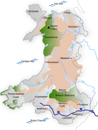
Snowdonia, or Eryri, is a mountainous region and national park in North Wales. It contains all 15 mountains in Wales over 3000 feet high, including the country's highest, Snowdon, which is 1,085 metres (3,560 ft) tall. These peaks are all part of the Snowdon, Glyderau, and Carneddau ranges in the north of the region. The shorter Moelwynion and Moel Hebog ranges lie immediately to the south.

<span class="mw-page-title-main">Brecon Beacons</span> Mountain range in Wales

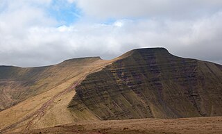
The Brecon Beacons are a mountain range in Wales. The range includes South Wales's highest mountain, Pen y Fan, its twin summit Corn Du, and Craig Gwaun Taf, which are the three highest peaks in the range. The Brecon Beacons have given their name to the larger Brecon Beacons National Park, and the range itself is therefore sometimes known as the Central Beacons to differentiate the two.

<span class="mw-page-title-main">Areas of Outstanding Natural Beauty in Wales</span> Designated area of countryside in Wales

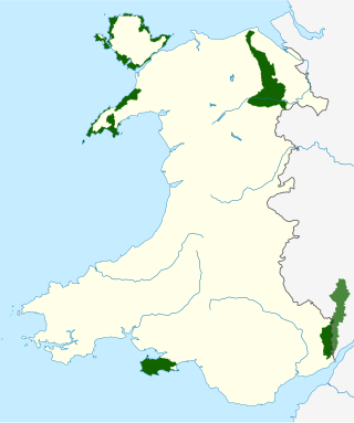
There are five Areas of Outstanding Natural Beauty (AONBs) in Wales, known from November 2023 as National Landscapes. AONBs are areas of countryside that have been designated for statutory protection, due to their significant landscape value, by initially the Government of the United Kingdom and later Welsh devolved bodies. Of the current five areas designated, four are wholly in Wales, with another spanning the Wales-England border, and in total AONBs account for 4% of Wales' land area.

<span class="mw-page-title-main">Brecknockshire</span> Historic county of Wales

Until 1974, Brecknockshire, also formerly known as the County of Brecknock, Breconshire, or the County of Brecon, was an administrative county in the south of Wales, later classed as one of the thirteen historic counties of Wales. Named after its county town of Brecon, the county was mountainous and primarily rural.

<span class="mw-page-title-main">Pembrokeshire Coast National Park</span> National park in Wales

Pembrokeshire Coast National Park is a national park along the Pembrokeshire coast in west Wales.

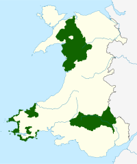
A national park authority is a special term used in Great Britain for legal bodies charged with maintaining a national park of which, as of October 2021, there are ten in England, three in Wales and two in Scotland. The powers and duties of all such authorities are similar, but their work varies depending on where they are situated.

<span class="mw-page-title-main">National parks of the United Kingdom</span> Areas of landscape in the United Kingdom

National parks of the United Kingdom are areas of relatively undeveloped and scenic landscape across the country. Despite their name, they are quite different from national parks in many other countries, which are usually owned and managed by governments as protected community resources, and which do not usually include permanent human communities. In the United Kingdom, an area designated as a national park may include substantial settlements and human land uses that are often integral parts of the landscape. Land within national parks remains largely in private ownership. These parks are therefore not "national parks" according to the internationally accepted standard of the IUCN but they are areas of outstanding landscape where planning controls are a little more restrictive than elsewhere.

<span class="mw-page-title-main">Pen y Fan</span> Welsh mountain peak of the Brecon Beacons, Powys

Pen y Fan is the highest peak in South Wales, situated in Brecon Beacons National Park. At 886 metres (2,907 ft) above sea-level, it is also the highest British peak south of Cadair Idris in Snowdonia. It is the highest point of the historic county of Brecknockshire. The twin summits of Pen y Fan and Corn Du at 873 metres (2,864 ft) were formerly referred to as Cadair Arthur or 'Arthur's Seat'.

<span class="mw-page-title-main">Geography of Wales</span> Overview of the geography of Wales

Wales is a country that is part of the United Kingdom and whose physical geography is characterised by a varied coastline and a largely upland interior. It is bordered by England to its east, the Irish Sea to its north and west, and the Bristol Channel to its south. It has a total area of 2,064,100 hectares and is about 170 mi (274 km) from north to south and at least 60 mi (97 km) wide. It comprises 8.35 percent of the land of the United Kingdom. It has a number of offshore islands, by far the largest of which is Anglesey. The mainland coastline, including Anglesey, is about 1,680 mi (2,704 km) in length. As of 2014, Wales had a population of about 3,092,000; Cardiff is the capital and largest city and is situated in the urbanised area of South East Wales.

<span class="mw-page-title-main">Black Mountain (range)</span> Mountain range, west of Brecon Beacons, Wales

The Black Mountain is a mountain range in South, Mid and West Wales, straddling the administrative boundary between Carmarthenshire and Powys and forming the westernmost range of the Brecon Beacons National Park. Its highest point is Fan Brycheiniog at 802 metres or 2,631 ft. The Black Mountain also forms a part of the Fforest Fawr Geopark.

<span class="mw-page-title-main">Geology of Wales</span> Overview of the geology of Wales

The geology of Wales is complex and varied; its study has been of considerable historical significance in the development of geology as a science. All geological periods from the Cryogenian to the Jurassic are represented at outcrop, whilst younger sedimentary rocks occur beneath the seas immediately off the Welsh coast. The effects of two mountain-building episodes have left their mark in the faulting and folding of much of the Palaeozoic rock sequence. Superficial deposits and landforms created during the present Quaternary period by water and ice are also plentiful and contribute to a remarkably diverse landscape of mountains, hills and coastal plains.

The Afon Pyrddin is a river forming a short section of the boundary between the counties of Brecknockshire and Glamorgan in Wales, United Kingdom. It also forms a part of the boundary of the Brecon Beacons National Park, and the boundary of the unitary authorities of Powys and Neath Port Talbot. The river and its waterfalls are one of the key attractions of the Fforest Fawr Geopark designated in 2005.

The National Park Visitor Centre, commonly known as the Brecon Beacons Mountain Centre, is a visitor centre managed by the Brecon Beacons National Park Authority, located in the village of Libanus some 8 km / 5 mi south-west of Brecon in Powys, south Wales. The centre provides information and interpretation for visitors to the area.

<span class="mw-page-title-main">Garreg Las</span> Mountain (635m) in Carmarthenshire, Wales

Garreg Las is a subsidiary summit of Fan Brycheiniog in the Brecon Beacons National Park in Carmarthenshire, southern Wales. Its summit sits towards the northern end of a broad north-south ridge, Esgair Hir, at 635 metres (2,083 ft) above sea level. The hill is sometimes referred to as Twyn Swnd.

<span class="mw-page-title-main">Protected areas of Wales</span> Designated area for protection in Wales

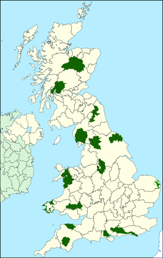
Wales, a country that is part of the United Kingdom, contains protected areas under various designations. The largest designation by land area is Wales' three national parks, followed by the five Areas of Outstanding Natural Beauty.

Brycheiniog was a small independent petty kingdom in South Wales in the Early Middle Ages. It can also refer to:

<span class="mw-page-title-main">Natural resources of Wales</span> Overview of natural resources in Wales

The natural resources of Wales have contributed substantially to the economic wealth of the United Kingdom from pre-Roman times to the present. Wales has a complex and varied geology with a wealth of natural minerals. Although Wales has been strongly associated with the coal industry, it has also been the world's leading supplier of slate and of copper at different times. The country lies along the western side of Great Britain and is buffeted by the prevailing South-Westerly trade winds which bring year round rain and wind but also maintain an equable temperate climate. The combination of climate and physical geography and geology have given rise to many different types of landscape and biomes rich in species variety.

The Wales Way is the name collectively given to a series of three tourist routes in Wales, UK, promoted by Visit Wales, the government agency charged with promoting tourism in the country. The three routes are the 180-mile Coastal Way, the 75-mile North Wales Way and the 185-mile Cambrian Way. The Wales Way was launched in late 2018.

The Eryri National Park Authority has recommended the use of some Welsh place-names, particularly for geographic features, such as lakes, which it is to use when referring to features in Snowdonia, which the authority refers to by its Welsh name Eryri.

References

  1. "National Parks of Wales". npapa.org.uk. npapa.org.uk. Retrieved 21 February 2021.
  2. 1 2 3 4 5 "The Review of Designated Landscapes in Wales STAGE TWO Response by National Parks Wales, May 2015" (PDF). May 2015.
  3. "The IUCN categories". www.nationalparks.gov.uk. UK ANPA. Archived from the original on 1 October 2012. Retrieved 16 August 2013.
  4. 1 2 "National Parks". National Parks. The Welsh Local Government Association (WLGA). Retrieved 21 February 2021.
  5. "History of the National Parks". National Parks: Britain's Breathing Space. Archived from the original on 10 October 2007. Retrieved 16 December 2007.
  6. "Our National Parks - Filex 1" (PDF). Exmoor National Park. Archived from the original (PDF) on 28 February 2008. Retrieved 3 December 2007.
  7. "Eryri - Snowdonia". www.eryri-npa.gov.uk.
  8. "The Geology of Snowdonia". Archived from the original on 16 September 2013.
  9. 1 2 3 "Pembrokeshire Coast National Park - A Wonder Filled Coast". Pembrokeshire Coast National Park.
  10. "Pembrokeshire crackdown on 'wild camping' in car parks". 7 August 2020 via www.bbc.co.uk.
  11. "Eryri - Snowdonia". www.eryri-npa.gov.uk. Retrieved 20 December 2016.
  12. Bannau Brycheiniog National Park Authority (17 April 2023). "Brecon Beacons National Park Reclaims Its Welsh Name" . Retrieved 17 April 2023.
  13. Morris, Steven (17 April 2023). "Brecon Beacons national park renamed Bannau Brycheiniog in Welsh language move". The Guardian . Retrieved 17 April 2023. The park authority CEO, Catherine Mealing-Jones, said: "The more we looked into it the more we realised the name Brecon Beacons doesn't make any sense. It's a very English description of something that probably never happened. A massive carbon-burning brazier is not a good look for an environmental organisation."
  14. "Basic Facts about the Brecon Beacons National Park" (PDF). Brecon Beacons National Park. Brecon Beacons National Park Authority. Retrieved 19 April 2020.
  15. "National Parks Listed in Chronological Order of Date Designated". National Parks. 27 June 2005. Archived from the original on 21 April 2013. Retrieved 6 March 2012.
  16. "Calls to create a Mid Wales National Park". Aberystwyth. Retrieved 20 November 2021.