Nebo, North Carolina

Last updated

Nebo, North Carolina
Country United States
State North Carolina
County McDowell
Area
[1]
  Total5.30 sq mi (13.72 km2)
  Land5.30 sq mi (13.72 km2)
  Water0.00 sq mi (0.00 km2)
Elevation
[2]
1,322 ft (403 m)
Population
 (2020)
  Total1,790
  Density337.99/sq mi (130.50/km2)
Time zone UTC-5 (Eastern (EST))
  Summer (DST) UTC-4 (EDT)
ZIP Code
28761.
GNIS feature ID2812797 [2]

Nebo is an unincorporated community and census-designated place (CDP) in the Nebo Township of eastern McDowell County, North Carolina, United States. [2] It was first listed as a CDP in the 2020 census with a population of 1,790. [3]

Contents

History

Nebo is named after a Methodist campground that existed before the Civil War. The Western North Carolina Railroad named its depot Nebo after the campground. The community was incorporated in 1909, with the repeal of the charter coming in 1943. [4]

Attractions

The primary attraction in Nebo is Lake James. Lake James State Park is located on its southern shore.

Education

Nebo Elementary School is located in the community. It serves children in kindergarten through fifth grade. The school was part of the last junior high system in the state of North Carolina which was replaced by the standard middle school model in the 2015–2016 school year. Before being incorporated as an elementary school, Nebo was a high school. Part of the high school burnt down years ago, but the lunchroom remained.

Location

The heart of Nebo is considered to be at the Nebo post office (28761). However, in recent times, Nebo has extended into Burke County due to new construction on Lake James. Some residents consider themselves to live in Nebo but reside just inside Burke County. This, however, is highly debatable, as the majority of residents of Nebo consider the boundary of Nebo to only cover the land area protected by the Nebo Volunteer Fire Department.

Demographics

Historical population
CensusPop.Note
2020 1
U.S. Decennial Census [5]
2020 [6]

2020 census

Nebo CDP, North Carolina – Racial and Ethnic Composition
(NH = Non-Hispanic)
Note: the US Census treats Hispanic/Latino as an ethnic category. This table excludes Latinos from the racial categories and assigns them to a separate category. Hispanics/Latinos may be of any race.
Race / EthnicityPop 2020 [6] % 2020
White alone (NH)1,61690.28%
Black or African American alone (NH)372.07%
Native American or Alaska Native alone (NH)90.50%
Asian alone (NH)201.12%
Pacific Islander alone (NH)00.00%
Some Other Race alone (NH)10.06%
Mixed Race/Multi-Racial (NH)573.18%
Hispanic or Latino (any race)502.79%
Total1,790100.00%

Note: the US Census treats Hispanic/Latino as an ethnic category. This table excludes Latinos from the racial categories and assigns them to a separate category. Hispanics/Latinos can be of any race.

Related Research Articles

<span class="mw-page-title-main">New Carrollton, Maryland</span> City in Maryland, United States

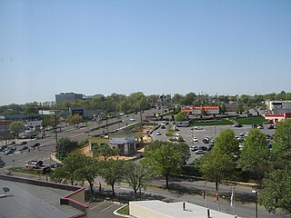
New Carrollton is a city located in central Prince George's County, Maryland, United States. As of the 2020 census, the population was 13,715. New Carrollton is located 10 miles (16 km) east of central Washington, D.C.

<span class="mw-page-title-main">Canyon Lake, Texas</span> CDP in Texas, United States

Canyon Lake is a census-designated place (CDP) in Comal County, Texas, United States. The population was 31,124 at the 2020 census. It is part of the San Antonio Metropolitan Statistical Area.

<span class="mw-page-title-main">Chester, Virginia</span> CDP in Virginia, United States

Chester is a census-designated place (CDP) in Chesterfield County, Virginia, United States. Per the 2020 census, the population was 23,414.

Peppermill Village is an unincorporated community near Maryland Route 214 in Prince George's County, Maryland, United States. Per the 2020 census, the population was 5,264. FedExField, Metrorail's Blue Line, and Hampton Mall shopping center are all located nearby. Because it is not formally incorporated, it has no official boundaries, but the United States Census Bureau has defined a census-designated place (CDP) consisting of Peppermill Village and the adjacent community of Carmody Hills, for statistical purposes.

Buford is an unincorporated community and census-designated place (CDP) in Lancaster County, South Carolina, United States. It was first listed as a CDP in the 2020 census with a population of 398. It lies at the intersection of South Carolina Highways 9 and 522.

Cataula is an unincorporated community and census-designated place (CDP) in Harris County, Georgia, United States.

<span class="mw-page-title-main">Carolina Forest, South Carolina</span> Census-designated place in South Carolina, United States

Carolina Forest is a census-designated place (CDP) in Horry County, South Carolina, United States. It was first listed as a CDP in the 2020 census with a population of 23,342.

Homewood is an unincorporated community and census-designated place (CDP) in Horry County, South Carolina, United States, just north of Conway in the northeastern part of the state. It was first listed as a CDP in the 2020 census with a population of 1,693.

<span class="mw-page-title-main">Rock Spring, Georgia</span> Census-designated place in Georgia, USA

Rock Spring is a unincorporated community and census-designated place located in northwest Georgia, United States, approximately 14 miles (23 km) south of Chattanooga, Tennessee. It is in Walker County which resides in Georgia's 14th congressional district. Rock Spring is included in the Chattanooga, TN-GA Metropolitan Statistical Area.

Deep Run is an unincorporated community and census-designated place (CDP) in southern Lenoir County, North Carolina, United States. It was first listed as a CDP in the 2020 census with a population of 572.

<span class="mw-page-title-main">Clyattville, Georgia</span> Census-designated place in Georgia, United States

Clyattville is an unincorporated community and census-designated place (CDP) in Lowndes County, Georgia, United States. It was established in the 1840s.

<span class="mw-page-title-main">Barnardsville, North Carolina</span> Census-designated place in North Carolina, United States

Barnardsville is an unincorporated community and census-designated place (CDP) in Buncombe County, North Carolina, United States. It was first listed as a CDP in the 2020 census with a population of 559.

Anderson Creek is a census-designated place located in the Anderson Creek Township of Harnett County, North Carolina, United States. It was first listed as a CDP in the 2020 census with a population of 13,636.

<span class="mw-page-title-main">Alexis, North Carolina</span> Census-designated place in North Carolina, United States

Alexis is an unincorporated community and census-designated place (CDP) in Gaston County, North Carolina, United States. It is located approximately three miles north of Stanley. It was first listed as a CDP in the 2020 census with a population of 589.

<span class="mw-page-title-main">Moselle, Mississippi</span> Community in Mississippi (USA)

Moselle is a census-designated place and unincorporated community in southern Jones County, Mississippi. The community is part of the Laurel micropolitan area.

Dacusville is a small unincorporated community and census-designated place (CDP) in Pickens County, South Carolina, United States. It is best known for its tractor show once a year in the month of September. The community also has an elementary school and a middle school. It was first listed as a CDP in the 2020 census with a population of 399.

<span class="mw-page-title-main">Conestee, South Carolina</span> Census-designated place in South Carolina, United States

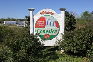
Conestee is an unincorporated community and census-designated place (CDP) in Greenville County, South Carolina, United States. It was first listed as a CDP in the 2020 census with a population of 904.

Drayton is an unincorporated community and census-designated place (CDP) in Spartanburg County, in the U.S. state of South Carolina. It was first listed as a CDP in the 2020 census with a population of 1,115.

Wyboo is a lakeside community and census-designated place (CDP) in Clarendon County, South Carolina, United States. It was first listed as a CDP prior to the 2020 census with a population of 3,661.

Ashwood is an unincorporated community and census-designated place (CDP) in Lee County, South Carolina, United States. It was first listed as a CDP prior to the 2020 census which showed a population of 116.

References

  1. "ArcGIS REST Services Directory". United States Census Bureau. Retrieved September 20, 2022.
  2. 1 2 3 U.S. Geological Survey Geographic Names Information System: Nebo, North Carolina
  3. "Nebo CDP, North Carolina". United States Census Bureau . Retrieved April 7, 2022.
  4. Powell, William S. The North Carolina Gazetteer: A Dictionary of Tar Heel Places, Chapel Hill, NC: The University of North Carolina Press, 1968.
  5. "Decennial Census by Decade". US Census Bureau.
  6. 1 2 "P2 HISPANIC OR LATINO, AND NOT HISPANIC OR LATINO BY RACE – 2020: DEC Redistricting Data (PL 94-171) – Nebo CDP, North Carolina". United States Census Bureau .

35°42′54″N81°55′52″W / 35.715°N 81.93111°W / 35.715; -81.93111