
Envisat is a large inactive Earth-observing satellite which is still in orbit. Operated by the European Space Agency (ESA), it was the world's largest civilian Earth observation satellite.
Shortwave radiation (SW) is radiant energy with wavelengths in the visible (VIS), near-ultraviolet (UV), and near-infrared (NIR) spectra.

A microwave radiometer (MWR) is a radiometer that measures energy emitted at millimetre-to-centimetre wavelengths known as microwaves. Microwave radiometers are very sensitive receivers designed to measure thermal electromagnetic radiation emitted by atmospheric gases. They are usually equipped with multiple receiving channels in order to derive the characteristic emission spectrum of the atmosphere or extraterrestrial objects. Microwave radiometers are utilized in a variety of environmental and engineering applications, including weather forecasting, climate monitoring, radio astronomy and radio propagation studies.

A thermographic camera is a device that creates an image using infrared radiation, similar to a common camera that forms an image using visible light. Instead of the 400–700 nanometre range of the visible light camera, infrared cameras are sensitive to wavelengths from about 1,000 nm (1 μm) to about 14,000 nm (14 μm). The practice of capturing and analyzing the data they provide is called thermography.

Infrared thermography (IRT), thermal imaging, and thermal video are examples of infrared imaging science. Thermographic cameras usually detect radiation in the long-infrared range of the electromagnetic spectrum and produce images of that radiation, called thermograms. Since infrared radiation is emitted by all objects with a temperature above absolute zero according to the black body radiation law, thermography makes it possible to see one's environment with or without visible illumination. The amount of radiation emitted by an object increases with temperature; therefore, thermography allows one to see variations in temperature. When viewed through a thermal imaging camera, warm objects stand out well against cooler backgrounds; humans and other warm-blooded animals become easily visible against the environment, day or night. As a result, thermography is particularly useful to the military and other users of surveillance cameras.

Clouds and the Earth's Radiant Energy System (CERES) is on-going NASA climatological experiment from Earth orbit. The CERES are scientific satellite instruments, part of the NASA's Earth Observing System (EOS), designed to measure both solar-reflected and Earth-emitted radiation from the top of the atmosphere (TOA) to the Earth's surface. Cloud properties are determined using simultaneous measurements by other EOS instruments such as the Moderate Resolution Imaging Spectroradiometer (MODIS). Results from the CERES and other NASA missions, such as the Earth Radiation Budget Experiment (ERBE), could lead to a better understanding of the role of clouds and the energy cycle in global climate change.

Atmospheric physics is the application of physics to the study of the atmosphere. Atmospheric physicists attempt to model Earth's atmosphere and the atmospheres of the other planets using fluid flow equations, chemical models, radiation budget, and energy transfer processes in the atmosphere. In order to model weather systems, atmospheric physicists employ elements of scattering theory, wave propagation models, cloud physics, statistical mechanics and spatial statistics which are highly mathematical and related to physics. It has close links to meteorology and climatology and also covers the design and construction of instruments for studying the atmosphere and the interpretation of the data they provide, including remote sensing instruments. At the dawn of the space age and the introduction of sounding rockets, aeronomy became a subdiscipline concerning the upper layers of the atmosphere, where dissociation and ionization are important.

Earth's energy budget accounts for the balance between the energy that Earth receives from the Sun, and the energy the Earth radiates back into outer space after having been distributed throughout the five components of Earth's climate system. This system is made up of Earth's water, ice, atmosphere, rocky crust, and all living things.

Actinometers are instruments used to measure the heating power of radiation. They are used in meteorology to measure solar radiation as pyranometers, pyrheliometers and net radiometers.

A pyranometer is a type of actinometer used for measuring solar irradiance on a planar surface and it is designed to measure the solar radiation flux density (W/m²) from the hemisphere above within a wavelength range 0.3 μm to 3 μm. The name pyranometer stems from the Greek words πῦρ (pyr), meaning "fire", and ἄνω (ano), meaning "above, sky".
A pyrgeometer is a device that measures near-surface infra-red radiation spectrum in the wavelength spectrum approximately from 4.5 μm to 100 μm.

A pressure system is a relative peak or lull in the sea level pressure distribution. The surface pressure at sea level varies minimally, with the lowest value measured 87 kilopascals (26 inHg) and the highest recorded 108.57 kilopascals (32.06 inHg). High- and low-pressure systems evolve due to interactions of temperature differentials in the atmosphere, temperature differences between the atmosphere and water within oceans and lakes, the influence of upper-level disturbances, as well as the amount of solar heating or radiationized cooling an area receives. Pressure systems cause weather to be experienced locally. Low-pressure systems are associated with clouds and precipitation that minimize temperature changes throughout the day, whereas high-pressure systems normally associate with dry weather and mostly clear skies with larger diurnal temperature changes due to greater radiation at night and greater sunshine during the day. Pressure systems are analyzed by those in the field of meteorology within surface weather maps.

The cloud top is the highest altitude of the visible portion of the cloud. It is traditionally expressed either in metres above the Earth surface, or as the corresponding pressure level in hectopascal.
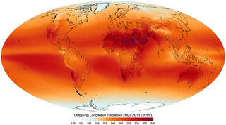
Outgoing Long-wave Radiation (OLR) is electromagnetic radiation of wavelengths from 3–100 μm emitted from Earth and its atmosphere out to space in the form of thermal radiation. It is also referred to as up-welling long-wave radiation and terrestrial long-wave flux, among others. The flux of energy transported by outgoing long-wave radiation is measured in W/m2. In the Earth's climate system, long-wave radiation involves processes of absorption, scattering, and emissions from atmospheric gases, aerosols, clouds and the surface.
The surface of the Sun radiates light and heat at approximately 5,500 °C. The Earth is much cooler and so radiates heat back away from itself at much longer wavelengths, mostly in the infrared range. The idealized greenhouse model is based on the fact that certain gases in the Earth's atmosphere, including carbon dioxide and water vapour, are transparent to the high-frequency, high-energy solar radiation, but are much more opaque to the lower frequency infrared radiation leaving the surface of the earth. Thus heat is easily let in, but is partially trapped by these gases as it tries to leave. Rather than get hotter and hotter, Kirchhoff's law of thermal radiation says that the gases of the atmosphere also have to re-emit the infrared energy that they absorb, and they do so, also at long infrared wavelengths, both upwards into space as well as downwards back towards the Earth's surface. In the long-term, thermal equilibrium is reached when all the heat energy arriving on the planet is leaving again at the same rate. In this idealized model, the greenhouse gases cause the surface of the planet to be warmer than it would be without them, in order for the required amount of heat energy finally to be radiated out into space from the top of the atmosphere.
Radiative flux, also known as radiative flux density or radiation flux, is the amount of power radiated through a given area, in the form of photons or other elementary particles, typically measured in W/m2. It is used in astronomy to determine the magnitude and spectral class of a star and in meteorology to determine the intensity of the convection in the planetary boundary layer. Radiative flux also acts as a generalization of heat flux, which is equal to the radiative flux when restricted to the infrared spectrum.
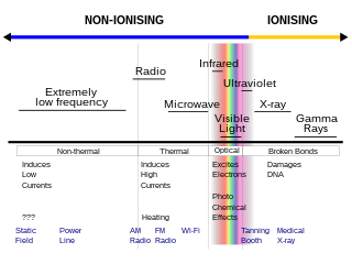
Non-ionizingradiation refers to any type of electromagnetic radiation that does not carry enough energy per quantum to ionize atoms or molecules—that is, to completely remove an electron from an atom or molecule. Instead of producing charged ions when passing through matter, non-ionizing electromagnetic radiation has sufficient energy only for excitation, the movement of an electron to a higher energy state. In contrast, ionizing radiation has a higher frequency and shorter wavelength than non-ionizing radiation, and can be a serious health hazard; exposure to it can cause burns, radiation sickness, cancer, and genetic damage. Using ionizing radiation requires elaborate radiological protection measures, which in general are not required with non-ionizing radiation.
Kosmos 122, launched on 25 June 1966, Meteor No.5L, and was one of eleven satellites put into orbit between 1964 and 1969 for the purpose of tracking weather. This launch was dubbed a Kosmos satellite mission because that was the designation given to prototype satellites by the Soviet Union. Kosmos 122 was the first announced Russian meteorological satellite and the last in a series of prototype meteorological satellites that included Kosmos 44, Kosmos 58, Kosmos 100, and Kosmos 118. It was the last meteorological satellite launched from the Baikonur site with a Vostok 2M launch vehicle at an orbital inclination of 65.0°, and it provided a transition from the prototype series to the Kosmos "Meteor" experimental weather satellite system. The deployment of two other satellites, Kosmos 144 and Kosmos 156, helped create the first Soviet weather forecasting network. Kosmos 122 and the other satellites had two cameras on board, one high resolution and one infrared in order to see the weather day or night. The Kosmos 122 was a successful mission and this specific satellite was used for four months. These satellites were used until 1969 when they were replaced with an upgraded model officially called Meteor.
Kosmos 144, was launched on 28 February 1967, Meteor No.6L, and was one of eleven weather satellites launched by the Soviet Union between 1964 and 1969. Kosmos 144 was the second announced Russian meteorological satellite and the first interim operational weather satellite in the experimental Kosmos satellite 'Meteor' system. It was also the first launch of the semi-operational weather satellite from the Plesetsk site into a near-polar, near-circular orbit. Unlike U.S. weather satellites, however, the orbit was prograde because, as a result of geographic limitations, a retrograde orbit was not possible. Kosmos 144 was orbited to test, in a semi-operational mode, meteorological instruments designed for obtaining images of cloud cover, snow cover, and ice fields on the day and night sides of the Earth and for measuring fluxes of outgoing radiation reflected and radiated by the Earth-atmosphere system. The launch of the Kosmos 144 satellite occurred after the success of the Kosmos 122 another meteorological satellite that was launched on 25 June 1966. These satellites were used until 1969 when they were replaced with an upgraded model officially called Meteor 1. The Kosmos 144 differed from the Kosmos 122 mission from Baikonur Cosmodrome to Plesetsk Cosmodrome that was used to get the satellite at the inclination that the satellite was left. The Kosmos 144 was also soon joined by the Kosmos 156, on 27 April 1967, which due to the orbit at which the satellites were positioned made it to where one of the satellites would pass over every six hours.
Kosmos 156 was a Soviet weather satellite launched on 27 April 1967, one of eleven weather satellites launched by the Soviet Union between 1964 and 1969. It formed part of the experimental "Meteor" weather satellite system. In 1969, the Kosmos satellite series was scrapped for the more modern and updated Meteor satellite.


