
Neshannock Township is a township in Lawrence County, Pennsylvania, United States. The population was 9,609 at the 2010 census.
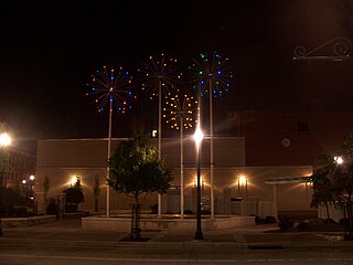
New Castle is a city in and the county seat of Lawrence County, Pennsylvania, United States. It is 50 miles (80 km) northwest of Pittsburgh near the Pennsylvania–Ohio border, approximately 18 miles (29 km) southeast of Youngstown, Ohio. As of the 2020 U.S. census, the city had a population of 21,926.

Oakwood is an unincorporated area and census-designated place (CDP) in Lawrence County, Pennsylvania, United States. The population was 2,270 at the 2010 census.
Shenango Township is a township in Lawrence County, Pennsylvania, United States. The population was 7,133 at the 2020 census, a decline from the figure of 7,479 tabulated in 2010. Shenango Township is situated between the city of New Castle to the north and the borough of Ellwood City to the south.

Slippery Rock Township is a township in Lawrence County, Pennsylvania, United States. As of the 2020 census, the population was 2,913, a decline from the figure of 3,283 tabulated in 2010.

Beaver River is a tributary of the Ohio River in Western Pennsylvania. It has a length of approximately 21 mi (34 km) and flows through a historically important coal-producing region north of Pittsburgh. Beaver River is formed in Lawrence County by the confluence of the Mahoning and Shenango rivers in the Mahoningtown neighborhood of New Castle. It flows generally south, past West Pittsburg and Homewood. It receives Connoquenessing Creek west of Ellwood City and flows past Beaver Falls and New Brighton. It joins the Ohio at Bridgewater and Rochester at the downstream end of a sharp bend in the Ohio approximately 20 mi (32 km) northwest of Pittsburgh. In the lower reaches near the Ohio River, the Beaver cuts through a gorge of underlying sandstone. The river is roughly parallel to the border with the state of Ohio, with both Interstate 376 and Pennsylvania Route 18 running parallel to the river itself.
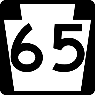
Pennsylvania Route 65, is a major 51-mile-long (82 km) state highway located in western Pennsylvania, United States. The route, traveling north–south from the Interstate 279/U.S. Route 19 Truck concurrency in Pittsburgh north to the PA 108/PA 168 concurrency in New Castle, connects downtown Pittsburgh to the northwestern portion of the Pittsburgh Metropolitan Area. PA 65 is similar in its purpose to PA 18 and PA 51, both of which run parallel to PA 65 at one point or another; however, the three routes pass through different cities for most of their respective alignments.

The Youngstown–Warren–Boardman, OH–PA Metropolitan Statistical Area, typically known as the Mahoning Valley, is a metropolitan area in Northeast Ohio and Western Pennsylvania with Youngstown, Ohio, at its center. According to the U.S. Census Bureau, the metropolitan statistical area (MSA) includes Mahoning and Trumbull counties in Ohio and Mercer County in Pennsylvania. As of the 2020 census, the region had a population of 541,243, making it the 107th largest metro area in the country.

Pennsylvania Route 108 is a highway in Western Pennsylvania that runs for 32 miles (51 km) from the Ohio state line near SNPJ to PA 8 in Adams Corner. PA 108 intersects Interstate 376 (I-376) near New Castle and U.S. Route 19 (US 19) near Harlansburg. PA 108 also has an interchange with Interstate 79 (I-79) at exit 105.

Pennsylvania Route 168 is a highway in Western Pennsylvania that runs for 55 miles (89 km) from PA 18 in Frankfort Springs to PA 208 in Volant. PA 168 intersects or runs concurrently with PA 18 at several points, including New Castle.
Pennsylvania House of Representatives District 8 is located in Western Pennsylvania and has been represented by Aaron Bernstine since 2023.

Pennsylvania Route 488 is a 17-mile-long (27 km) state highway located in Lawrence and Butler Counties in Pennsylvania. The western terminus is at PA 65/PA 288 in Ellwood City. The eastern terminus is at U.S. Route 422 in Moraine State Park.
Pennsylvania State Senate District 50 includes part of Lawrence County and all of Crawford County and Mercer County. It is currently represented by Republican Michele Brooks.

Mahoningtown also known as "Motown" is a neighborhood in the southwestern part of the city of New Castle, Pennsylvania, United States. Though it is named for the nearby Mahoning River, the city actually sits on the banks of the Shenango River. The two rivers merge and become the Beaver River just south of the city.
The 9th Pennsylvania House of Representatives District is in western Pennsylvania. As of 2023, it is represented by Marla Brown.
The Westmoreland County Transit Authority (WCTA) is the operator of mass transportation in Westmoreland County, Pennsylvania. Using 35 buses, a total of 18 routes are operated, the majority of which serve the urbanized corridor that makes up the western portion of the county. Bus routes in this area are designed to provide access for suburban commuters to Downtown Pittsburgh, as well as transportation for both workers and shoppers to the large suburbs of Greensburg and New Kensington, Pennsylvania the most prominent entities in the county's boundaries. Rural eastern bus routes allow for commutes to Greensburg and also provide service to the city of Johnstown in neighboring Cambria County.

Shenango Area School District is a public school district located in Lawrence County, Pennsylvania, United States. The district serves Shenango Township and South New Castle Borough. 700 students currently attend the district's elementary school, while an additional 750 are part of the junior-senior high school. Colors are Navy Blue and Gold. The mascot is the Wildcat.

Lawrence County is a county in the Commonwealth of Pennsylvania. As of the 2020 census, the population was 86,070. The county seat is New Castle.
Neshannock Creek is a 25.65 mi (41.28 km) long tributary to Shenango River that forms at the confluence of Cool Spring and Otter Creek in Mercer County and then flows south to Lawrence County, Pennsylvania. This creek is known for its fly fishing at Volant, Pennsylvania.
The Stavich Bike Trail is a National Recreation Trail located in Mahoning County, Ohio and Lawrence County, Pennsylvania. The rail trail is 9.9 miles long and goes from Lowellville to Union Township in Lawrence County, traveling directly through Lowellville. It was constructed on the former Penn-Ohio Electric System trolley line along the Mahoning River in 1983, adjacent to the CSX New Castle Subdivision tracks. Considered an early example of rail-trails, its 1983 construction was dependent on a donation from the Stavich family, who ran many aluminum mills in the Youngstown area.
