New Cuyama, California

Last updated

New Cuyama
New Cuyama.jpg
New Cuyama in an aerial photo looking west, taken in 2015
USA California location map.svg
Red pog.svg
New Cuyama
Position in California
Coordinates: 34°56′53″N119°41′21″W / 34.94806°N 119.68917°W / 34.94806; -119.68917
Country Flag of the United States.svg  United States
State Flag of California.svg  California
County Santa Barbara
Settled1822
Area
[1]
  Total0.706 sq mi (1.827 km2)
  Land0.706 sq mi (1.827 km2)
  Water0 sq mi (0 km2)  0%
Elevation
2,150 ft (660 m)
Population
 (2020)
  Total542
  Density770/sq mi (300/km2)
Time zone UTC-8 (PST)
  Summer (DST) UTC-7 (PDT)
ZIP code
93254
Area code 661
Website www.countyofsb.org
New Cuyama in a 2015 aerial photo of the Cuyama Valley Cuyama Valley, California (21395922259).jpg
New Cuyama in a 2015 aerial photo of the Cuyama Valley

New Cuyama (Chumash: Kuyam, meaning "Clam") [2] is a census-designated place in the Cuyama Valley, Santa Barbara County, California. It was named after the Chumash word for "clams", most likely due to the millions of petrified prehistoric clamshell fossils that are found in the surrounding areas. The town is home to the majority of the utility infrastructure for its residents, including nearby neighbor Cuyama, California. New Cuyama is located very close to the intersection points for Santa Barbara, San Luis Obispo, Ventura and Kern counties. The town is served by Highway 166 (connecting U.S. Route 101 and Interstate 5) and the public-use New Cuyama Airport. The population was 542 at the 2020 census.

Contents

History

The area was considered territory of the Yokuts people, but Chumash Indians from the Pacific Coast are also known to have frequented the area. The imprint of an old Indian trail can still be seen leading over the hills of present-day Ventura County to the headwaters of Piru Creek. The name "Cuyama" comes from an Indian village named for the Chumash word kuyam, meaning "clam" or "freshwater mollusk". [2]

The area's recorded history dates to 1822, when Mexico won independence from Spain and took over the Spanish colony of Alta California. Two Mexican land grants, the Rancho Cuyama (Lataillade) and Rancho Cuyama (Rojo), were granted in the 1840s by Governors Manuel Micheltorena and Pío Pico in the lower Cuyama Valley along the Cuyama River, where present-day New Cuyama is, privatizing ownership of the land.

Following the 1949 discovery of oil at the South Cuyama Oil Field, in 1952 the Atlantic Richfield Company (ARCO) settled and developed the town of New Cuyama, building housing and associated commercial business – including the New Cuyama Airport (L88), reopened in May 2015, [3] [4] which bears the distinction of being the only public-use paved airport within easy flying range of Los Angeles for more than 50 miles (80 km).[ citation needed ] Much of the infrastructure from ARCO's settling of the town still exists today and is used by town residents. The original ARCO-built gas processing plant is still in use and easily seen due south of New Cuyama, though ARCO has since sold off interest in the facility. [5]

The town of New Cuyama, at its founding, was considered the pearl of eastern Santa Barbara County, due to the flow of oil that was coming out of the region. During this time Richfield Oil Company built the town funded schools and provided all the important utilities other than electricity. Now that oil and gas production have declined, the principal industry is once again agriculture.

Geography

New Cuyama is located at 34°56′53″N119°41′21″W / 34.947933°N 119.68915°W / 34.947933; -119.68915 (34.947933, -119.68915). [6] It is situated in the Cuyama Valley.

According to the United States Census Bureau, the CDP covers an area of 0.7 square miles (1.8 km2), all of it land.

Humorous sign, 4923 Primero St., New Cuyama (note the total) US-CA, New cuyama.jpg
Humorous sign, 4923 Primero St., New Cuyama (note the total)

Climate

New Cuyama has a steppe climate (BSk). This region experiences hot and dry summers, with the warmest month having a daily mean of 75 degrees.

Climate data for New Cuyama, California, 1991–2020 normals, extremes 1974–present
MonthJanFebMarAprMayJunJulAugSepOctNovDecYear
Record high °F (°C)88
(31)
87
(31)
90
(32)
97
(36)
106
(41)
108
(42)
110
(43)
108
(42)
108
(42)
102
(39)
92
(33)
84
(29)
110
(43)
Mean maximum °F (°C)75.7
(24.3)
76.9
(24.9)
80.6
(27.0)
87.5
(30.8)
94.6
(34.8)
99.9
(37.7)
103.6
(39.8)
102.8
(39.3)
99.3
(37.4)
92.5
(33.6)
83.8
(28.8)
74.8
(23.8)
105.2
(40.7)
Average high °F (°C)61.1
(16.2)
62.0
(16.7)
65.6
(18.7)
70.9
(21.6)
79.5
(26.4)
88.3
(31.3)
94.6
(34.8)
93.5
(34.2)
88.9
(31.6)
78.4
(25.8)
67.6
(19.8)
60.6
(15.9)
75.9
(24.4)
Daily mean °F (°C)47.1
(8.4)
48.1
(8.9)
51.2
(10.7)
55.2
(12.9)
62.4
(16.9)
69.8
(21.0)
75.6
(24.2)
74.5
(23.6)
70.2
(21.2)
60.9
(16.1)
51.8
(11.0)
46.4
(8.0)
59.4
(15.2)
Average low °F (°C)33.2
(0.7)
34.1
(1.2)
36.9
(2.7)
39.5
(4.2)
45.3
(7.4)
51.4
(10.8)
56.7
(13.7)
55.5
(13.1)
51.5
(10.8)
43.4
(6.3)
36.1
(2.3)
32.2
(0.1)
43.0
(6.1)
Mean minimum °F (°C)23.2
(−4.9)
24.8
(−4.0)
28.0
(−2.2)
30.0
(−1.1)
36.4
(2.4)
41.5
(5.3)
48.4
(9.1)
47.4
(8.6)
42.8
(6.0)
33.2
(0.7)
25.8
(−3.4)
22.3
(−5.4)
19.8
(−6.8)
Record low °F (°C)9
(−13)
15
(−9)
20
(−7)
22
(−6)
25
(−4)
29
(−2)
35
(2)
35
(2)
35
(2)
20
(−7)
17
(−8)
7
(−14)
7
(−14)
Average precipitation inches (mm)1.49
(38)
1.62
(41)
1.49
(38)
0.48
(12)
0.28
(7.1)
0.03
(0.76)
0.10
(2.5)
0.01
(0.25)
0.08
(2.0)
0.22
(5.6)
0.46
(12)
1.10
(28)
7.36
(187.21)
Average precipitation days (≥ 0.01 in)6.36.65.12.91.70.20.40.10.61.52.64.932.9
Source 1: NOAA [7]
Source 2: National Weather Service [8]

Demographics

The 2010 United States Census [9] reported that New Cuyama had a population of 517. The population density was 732.7 inhabitants per square mile (282.9/km2). The racial makeup of New Cuyama was 418 (80.9%) White, 3 (0.6%) African American, 14 (2.7%) Native American, 3 (0.6%) Asian, 0 (0.0%) Pacific Islander, 53 (10.3%) from other races, and 26 (5.0%) from two or more races. Hispanic or Latino of any race were 234 persons (45.3%).

The Census reported that 517 people (100% of the population) lived in households, 0 (0%) lived in non-institutionalized group quarters, and 0 (0%) were institutionalized.

There were 177 households, out of which 69 (39.0%) had children under the age of 18 living in them, 95 (53.7%) were opposite-sex married couples living together, 15 (8.5%) had a female householder with no husband present, 12 (6.8%) had a male householder with no wife present. There were 15 (8.5%) unmarried opposite-sex partnerships, and 1 (0.6%) same-sex married couples or partnerships. 45 households (25.4%) were made up of individuals, and 20 (11.3%) had someone living alone who was 65 years of age or older. The average household size was 2.92. There were 122 families (68.9% of all households); the average family size was 3.54.

The population was spread out, with 160 people (30.9%) under the age of 18, 43 people (8.3%) aged 18 to 24, 125 people (24.2%) aged 25 to 44, 126 people (24.4%) aged 45 to 64, and 63 people (12.2%) who were 65 years of age or older. The median age was 35.1 years. For every 100 females, there were 105.2 males. For every 100 females age 18 and over, there were 97.2 males.

There were 215 housing units at an average density of 304.7 per square mile (117.6/km2), of which 119 (67.2%) were owner-occupied, and 58 (32.8%) were occupied by renters. The homeowner vacancy rate was 1.7%; the rental vacancy rate was 9.2%. 313 people (60.5% of the population) lived in owner-occupied housing units and 204 people (39.5%) lived in rental housing units.

See also

Related Research Articles

<span class="mw-page-title-main">Santa Barbara County, California</span> County in California, United States

Santa Barbara County, officially the County of Santa Barbara, is located in Southern California. As of the 2020 census, the population was 448,229. The county seat is Santa Barbara, and the largest city is Santa Maria.

<span class="mw-page-title-main">Ventura County, California</span> County in California, United States

Ventura County is a county in the southern part of the U.S. state of California. As of the 2020 census, the population was 843,843. The largest city is Oxnard, and the county seat is the city of Ventura.

<span class="mw-page-title-main">Nipomo, California</span> Place in California, United States

Nipomo is a unincorporated town in San Luis Obispo County, California, United States. The population was 16,714 for the 2010 census and grew to 18,176 for the 2020 census. For statistical purposes, the United States Census Bureau has defined Nipomo as a census-designated place (CDP).

<span class="mw-page-title-main">Pismo Beach, California</span> City in California, United States

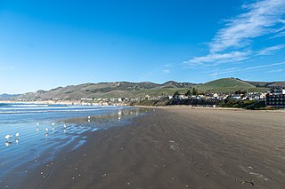
Pismo Beach is a city in the southern portion of San Luis Obispo County, in the Central Coast area of California, United States. Its estimated population was 8,072 at the 2020 census, up from 7,655 in the 2010 census. It is part of the Five Cities area, a cluster of cities in that area. The Five Cities area historically is made up of Arroyo Grande, Grover City, Halcyon, Fair Oaks, and Nipomo. Now most people refer to the Five Cities as Grover Beach, Pismo Beach, Shell Beach, Arroyo Grande, and Oceano.

<span class="mw-page-title-main">Goleta, California</span> City in California, United States

Goleta is a city in southern Santa Barbara County, California, United States. It was incorporated as a city in 2002, after a long period as the largest unincorporated populated area in the county. As of the 2000 census, the census-designated place had a total population of 55,204. A significant portion of the census territory of 2000 did not incorporate into the new city. The population of Goleta was 32,690 at the 2020 census. It is known for being near the University of California, Santa Barbara, campus.

<span class="mw-page-title-main">Isla Vista, California</span> Census-designated place in California, United States

Isla Vista is an unincorporated community and census-designated place (CDP) in Santa Barbara County, California in the United States. As of 2020 census, the community had a population of 15,500. The majority of residents are college students at the University of California, Santa Barbara or at Santa Barbara City College. The beachside community of Isla Vista lies on a flat plateau about 30 feet (9 m) in elevation, separated from the beach by a bluff.

<span class="mw-page-title-main">Santa Ynez, California</span> Census-designated place in California, United States

Santa Ynez is a census-designated place (CDP) in the Santa Ynez Valley of Santa Barbara County, California.

<span class="mw-page-title-main">Summerland, California</span> Census designated place in California, United States

Summerland is a census designated place (CDP) in Santa Barbara County, California. The population was 1,448 at the 2010 census, down from 1,545 at the 2000 census.

<span class="mw-page-title-main">El Rio, California</span> Place in California, United States

El Rio is a small, rural unincorporated town in Ventura County, California, United States, on the northeast side of the 101 Freeway and Oxnard, and south of the Santa Clara River. The town was founded in 1875 and named New Jerusalem by the owner of general store who became the first postmaster in 1882. In 1885, a school and Santa Clara Catholic Church were built. Located near where the coastal railroad line crosses the Santa Clara River, the town's name was changed to El Rio around 1900. The former wagon river crossing route became the Ventura Freeway which separates the community from the commercial developments that grew up on the southwest side of the freeway. That portion of the historic community and sections closer to the river have been annexed to the city of Oxnard. Vineyard Avenue is the central business district for the largely residential community.

<span class="mw-page-title-main">Piru, California</span> Unincorporated community in Ventura County, California

Piru is a small unincorporated historic town located in eastern Ventura County, California, in the Santa Clara River Valley near the Santa Clara River and Highway 126, about seven miles (11 km) east of Fillmore and about 13 miles (21 km) west of Interstate 5. Lake Piru, in the Los Padres National Forest, is the main recreational attraction. The population was 2,063 at the 2010 census, up from 1,196 when the 2000 census was enumerated. For statistical purposes, the United States Census Bureau has defined Piru as a census-designated place (CDP), which does not precisely correspond to the historical community.

<span class="mw-page-title-main">Cuyama, California</span> Census-designated place in California, United States

Cuyama is a census-designated place in Santa Barbara County. California. It is located in the Cuyama Valley, near the Carrizo Plain. The Cuyama River runs adjacent to the town, flowing west towards the Pacific Ocean. Cuyama is surrounded by many apricot, peach, and plum orchards. The ZIP Code is 93254, and the community is inside area code 805. The population was 57 at the 2010 census. The name "Cuyama" comes from an Indian village named Kuyam.

<span class="mw-page-title-main">Santa Margarita, California</span> Census-designated place in California, United States

Santa Margarita is a town and census-designated place located in San Luis Obispo County, California. It was founded in 1889 near Cuesta Peak and San Luis Obispo along State Route 58. The town's name comes from the Mexican Alta California land grant of Rancho Santa Margarita. It is home to the Santa Margarita de Cortona Asistencia site. The population was 1,259 at the 2010 census.

<span class="mw-page-title-main">Cuyama River</span> River in California, United States

The Cuyama River is a 118-mile-long (190 km) river in southern San Luis Obispo County, northern Santa Barbara County, and northern Ventura County, in the U.S. state of California. It joins the Sisquoc River forming the Santa Maria River. The river's name comes from an Indian village named for the Chumash word kuyam, meaning "clam" or "freshwater mollusk".

<span class="mw-page-title-main">Saticoy, California</span> Place in California, United States

Saticoy is an unincorporated community in Ventura County, California, United States. The settlement was laid out in 1887 along the railroad line that was being built from Los Angeles through the Santa Clara River Valley to the town of San Buenaventura. Although the town was 10 miles (16 km) distant at that time, the City of Ventura grew to a point where the community is now just outside the city limits. For statistical purposes, the United States Census Bureau has defined Saticoy as a census-designated place (CDP).

<span class="mw-page-title-main">Casmalia, California</span> Census-designated place in California, United States

Casmalia is a census-designated place (CDP) in Santa Barbara County, California located just outside the borders of Vandenberg Air Force Base about 5 miles (8.0 km) southwest of Santa Maria. The ZIP Code is 93429, and the community is inside area code 805. The population was 138 at the 2010 census.

<span class="mw-page-title-main">South Cuyama Oil Field</span>

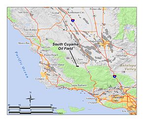
The South Cuyama Oil Field is a large oil and gas field in the Cuyama Valley and the adjacent northern foothills of the Sierra Madre Mountains in northeastern Santa Barbara County, California. Discovered in 1949, and with a cumulative production of around 225 million barrels (35,800,000 m3) of oil, it ranks 27th in size in the state, but is believed to retain only approximately two percent of its original oil, according to the official estimates of the California Department of Oil, Gas, and Geothermal Resources (DOGGR). Of the top forty onshore oil fields in California, it is the most recent to be discovered, but by the end of 2008 only 87 wells remained in production.

<span class="mw-page-title-main">Cuyama Valley</span> Valley along the Cuyama river in California

The Cuyama Valley is a valley along the Cuyama River in central California, in northern Santa Barbara, southern San Luis Obispo, southwestern Kern, and northwestern Ventura counties. It is about two hours driving time from both Los Angeles and the Santa Barbara area.

<span class="mw-page-title-main">Simi Valley, California</span> City in California, United States

Simi Valley is a city in the valley of the same name in the southeast region of Ventura County, California, United States. Simi Valley is 40 miles (65 km) from Downtown Los Angeles, making it part of the Greater Los Angeles Area. The city sits next to Thousand Oaks, Moorpark, and Chatsworth. As of the 2020 U.S. Census the population was 126,356, up from 124,243 in 2010. The city of Simi Valley is surrounded by the Santa Susana Mountains and the Simi Hills, west of the San Fernando Valley, and northeast of the Conejo Valley. It grew as a commuter bedroom community for the cities in the Los Angeles area, and the San Fernando Valley when a freeway was built over the Santa Susana Pass.

<span class="mw-page-title-main">Russell Ranch Oil Field</span>

The Russell Ranch Oil Field is an oil and gas field in the Cuyama Valley of northern Santa Barbara and southern San Luis Obispo Counties, California, in the United States. Discovered in 1948, and reaching peak production in 1950, it has produced over 68 million barrels (10,800,000 m3) of oil in its lifetime; with only an estimated 216,000 barrels (34,300 m3) of recoverable oil remaining, and having produced around 66,000 in 2008, it is considered to be close to exhaustion. The primary operator on the field as of 2010 is E&B Natural Resources, which also runs the nearby South Cuyama Oil Field.

<span class="mw-page-title-main">Santa Susana, California</span> Place in California, United States

Santa Susana is a former railroad town located mostly within the City of Simi Valley. A small portion of the community, outside the Simi Valley city limits to the south of the Ventura County Metrolink rail line, is an unincorporated area and census-designated place (CDP). The community is in the eastern part of the Simi Valley.

References

  1. U.S. Census Archived 2011-02-20 at the Wayback Machine
  2. 1 2 Bright, William; Erwin G. Gudde (1998). 1500 California Place Names: Their Origin and Meaning. University of California Press. p. 46. ISBN   0-520-21271-1.
  3. "New Cuyama Airport reopens — General Aviation News".
  4. "L88 New Cuyama | EAA Chapter 527 – KSBA". sbaero.com. Archived from the original on May 30, 2015.
  5. San Luis Obispo County High Point Trip Report
  6. "US Gazetteer files: 2010, 2000, and 1990". United States Census Bureau. February 12, 2011. Retrieved April 23, 2011.
  7. "U.S. Climate Normals Quick Access – Station: New Cuyama Fire STN, CA". National Oceanic and Atmospheric Administration. Retrieved May 7, 2023.
  8. "NOAA Online Weather Data – NWS Los Angeles". National Weather Service. Retrieved May 7, 2023.
  9. "2010 Census Interactive Population Search: CA - New Cuyama CDP". U.S. Census Bureau. Archived from the original on July 15, 2014. Retrieved July 12, 2014.