
Lompoc is a city in Santa Barbara County, California, United States. Located on the Central Coast, its population was 43,834 as of July 2021.

Santa Maria is a city in the Central Coast of California in northern Santa Barbara County. It is approximately 65 miles (105 km) northwest of Santa Barbara and 150 miles (240 km) northwest of downtown Los Angeles. Its population was 109,707 at the 2020 census, making it the most populous city in the county and the Santa Maria-Santa Barbara, CA Metro Area. The city is notable for its wine industry and Santa Maria–style barbecue.

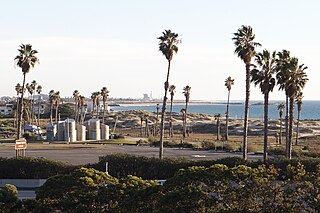
Vandenberg Space Force Base, previously Vandenberg Air Force Base, is a United States Space Force Base in Santa Barbara County, California. Established in 1941, Vandenberg Space Force Base is a space launch base, launching spacecraft from the Western Range, and also performs missile testing. The United States Space Force's Space Launch Delta 30 serves as the host delta for the base, equivalent to an Air Force air base wing. In addition to its military space launch mission, Vandenberg Space Force Base also hosts space launches for civil and commercial space entities, such as NASA and SpaceX.
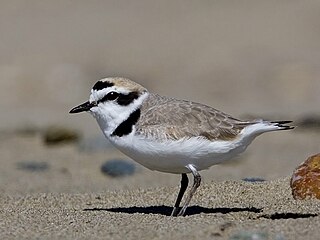
The snowy plover is a small shorebird found in the Americas. It is a member of the bird family Charadriidae, which includes the plovers, dotterels, and lapwings. The snowy plover was originally described by John Cassin in 1858, but was classified as a subspecies of the Kentish plover in 1922. Since 2011, the snowy plover has been recognized as a distinct species based on genetic and anatomical differences from the Kentish plover. Two or three subspecies are recognized, distributed along the Pacific coast of North America, Ecuador, Peru, and Chile, in several inland areas of the US and Mexico, along the Gulf Coast, and on Caribbean islands. The coastal populations consist of both residential and migratory birds, whereas the inland populations are mostly migratory. It is one of the best studied endemic shorebirds of the Americas, and one of the rarest.

The San Diegan was one of the named passenger trains of the Atchison, Topeka and Santa Fe Railway, and a “workhorse” of the railroad. Its 126-mile (203-kilometer) route ran from Los Angeles, California south to San Diego. It was assigned train Nos. 70–79.
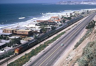
The Surf Line is a railroad line that runs from San Diego to Orange County along California's Pacific coast. It was so named because much of the line is near the Pacific Ocean, within less than 100 feet (30 m) in some places. It is the second busiest passenger rail corridor in the United States after the Northeast Corridor.

Guadalupe-Nipomo Dunes is the largest remaining dune system south of San Francisco and the second largest in the U.S. state of California. It encompasses an 18-mile (29 km) stretch of coastline on the Central Coast of California and extends from southern San Luis Obispo County to northern Santa Barbara County.
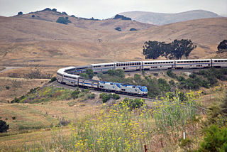
The Coast Line is a railroad line between Burbank, California and the San Francisco Bay Area, roughly along the Pacific Coast. It is the shortest rail route between Los Angeles and the Bay Area. Though not as busy as the Surf Line, the continuation of the Coast Line southbound to San Diego, it still sees freight movements and lots of passenger trains. The Pacific Surfliner, which runs from the San Diego Santa Fe Depot to San Luis Obispo via Union Station in Los Angeles, is the third busiest Amtrak route, and the busiest outside of the Northeast Corridor between Washington D.C. and Boston.
Malibu Lagoon State Beach in Malibu, California, United States, is also known as Surfrider Beach. It was dedicated as the first World Surfing Reserve on October 9, 2010. The 110-acre (45 ha) site was established as a California state park in 1951. It lies within the Santa Monica Mountains National Recreation Area.

Santa Fe Depot is a union station in San Diego, California, built by the Atchison, Topeka and Santa Fe Railway to replace the small Victorian-style structure erected in 1887 for the California Southern Railroad Company. The Spanish Colonial Revival style station is listed on the National Register of Historic Places and is a San Diego Historic Landmark. Its architecture, particularly the signature twin domes, is often echoed in the design of modern buildings in downtown San Diego.

The Solana Beach Transit Center is a train station on Amtrak California's Pacific Surfliner passenger train and on North County Transit District's COASTER commuter rail route located in Solana Beach, California. The tracks were lowered to their current position in the late 90s, to alleviate congestion on Lomas Santa Fe Road and Downtown Solana Beach. There are two tracks that carry the Surf Line in a trench through the city of Solana Beach, including the station.

Lompoc–Surf station is a passenger rail station in Surf, California, west of the city of Lompoc. It is served by Amtrak's Pacific Surfliner from San Luis Obispo to San Diego.

Santa Monica State Beach is a California State Park operated by the city of Santa Monica.
San Buenaventura State Beach is a beach located in Ventura, California. The primary entrance is at 901 Pedro Street, off the 101 Freeway.
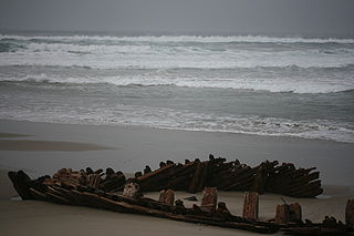
Sibyl Marston was a wooden schooner cargo ship built by W. A. Boole & Son of Oakland, California and belonging to the Sibyl Marston Co. Sibyl Marston sank off the coast of Lompoc, California on 12 January 1909.
Ormond Beach is an industrial region of the city of Oxnard in Ventura County, Southern California. It's situated southeast of the neighboring community of Port Hueneme and extends southeast to Naval Air Station Point Mugu.

The western snowy plover is a small wader in the plover bird family. They are currently federally listed under the U.S. Endangered Species Act as Threatened. Human activity, habitat loss and predation are the biggest contributors to population degradation. A recovery plan was approved under the US Fish and Wildlife Service in 2007. Recovery actions and monitoring are crucial for these vulnerable seabirds.

Moss Landing Wildlife Area is a California State wildlife preserve on the shore of Elkhorn Slough.
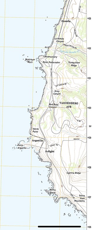
Honda was a remote and sparsely populated rural district in the vicinity of Cañada Honda Creek in Santa Barbara County, California, United States. The area produced sweet peas and beans, and supported dairy farms. A newspaper account of 1947 stated, "The Jesus Maria rancho, Packard rancho, Bear Creek ranch, Honda section, and a large area in the lower [Lompoc] valley once yielded great crops of cattle and produce and furnished a livelihood for many families." The area is now part of Vandenberg Space Force Base.
The 1927 Lompoc earthquake occurred on November 4 at 05:49 PST with an epicenter off the coast of Santa Barbara County Southern California. The earthquake measured 7.0 on the moment magnitude scale and had a maximum Modified Mercalli intensity of IX (Violent). It caused widespread damage in several towns of Santa Barbara County. A 2 m tsunami damaged railroad infrastructure and was recorded in Hawaii. There were no injuries or deaths from the earthquake.


