New Market, Maryland

Last updated

New Market, Maryland
Town of New Market
New Market HD MD1.jpg
Flag of New Market, Maryland.svg
Logo of New Market, Maryland.svg
Frederick County Maryland Incorporated and Unincorporated areas New Market Highlighted.svg
Location of New Market, Maryland
Coordinates: 39°23′1″N77°16′24″W / 39.38361°N 77.27333°W / 39.38361; -77.27333
Country Flag of the United States.svg  United States of America
State Flag of Maryland.svg  Maryland
County Flag of Frederick County, Maryland.svg Frederick
Incorporated 1878 [1]
Area
[2]
  Total1.62 sq mi (4.21 km2)
  Land1.62 sq mi (4.20 km2)
  Water0.00 sq mi (0.00 km2)
Elevation
[3]
545 ft (166 m)
Population
 (2020)
  Total1,525
  Density939.62/sq mi (362.79/km2)
Time zone UTC-5 (Eastern (EST))
  Summer (DST) UTC-4 (EDT)
ZIP code
21774
Area code(s) 301, 240
FIPS code 24-55650
GNIS feature ID2391325 [3]
Website www.townofnewmarket.org

New Market is a town in Frederick County, Maryland, United States. The population was 1,525 at the 2020 census. The town bills itself as the "Antiques capital of Maryland".

Contents

Geography

According to the United States Census Bureau, the town has a total area of 0.80 square miles (2.07 km2), all land. [4]

History

When Frederick, Maryland began being settled in 1745, trade routes between Frederick and Baltimore emerged. Present-day New Market developed along this road, which later was improved. It became known as the National Road and the Gateway to the West. In 1926, U.S. Route 40, a major coast-to-coast highway, was constructed and designated along the former National Road.

To accommodate travelers along this important colonial road, Nicholas Hall tried to plat the town of New Market in 1788. He likely had disputes with William Plummer, an owner of adjoining land and was unable to complete the project. On August 1, 1792, William Plummer laid out 36 lots for the town. Later, on January 29, 1793, Nicholas Hall laid out an additional 134 lots. On June 1, 1793, the first 19 lots were sold, initiating the town of New Market. As time passed, the town developed as an important stopping point along the route. Residents developed churches, hotels, inns, a post office, taverns, blacksmith shops, and other crucial services, including doctors.

The New Market Historic District was listed on the National Register of Historic Places in 1975. [5] Henry Nelson House was listed on the NRHP in 1980 and Drummine Farm in 1987. [5]

Antiques Capital of Maryland

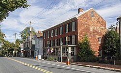
New Market was once known as the "Antiques Capital of Maryland". [6] Downtown New Market once had a number of small shops specializing in the sale of antiques and other goods.[ citation needed ] While antiques tourism occurs year-round, New Market holds events and festivals that highlight the town's historic past. "Christmas in New Market" is held on the first Saturday in December every year. From June through October each year, New Market hosts periodic 2nd Saturday events, featuring artists, food, vendors, free concerts, and movies. A "Day in New Market" festival was formerly held annually on the first Saturday in May.[ citation needed ]

Demographics

Historical population
CensusPop.Note
1880 402
1890 4235.2%
1900 360−14.9%
1910 320−11.1%
1920 274−14.4%
1930 2947.3%
1940 36022.4%
1950 301−16.4%
1960 35818.9%
1970 339−5.3%
1980 306−9.7%
1990 3287.2%
2000 42730.2%
2010 65653.6%
2020 1,525132.5%
U.S. Decennial Census [7]

2010 census

As of the census [8] of 2010, there were 656 people, 231 households, and 187 families residing in the town. The population density was 820.0 inhabitants per square mile (316.6/km2). There were 247 housing units at an average density of 308.8 per square mile (119.2/km2). The racial makeup of the town was 89.5% White, 5.5% African American, 0.3% Native American, 2.3% Asian, 0.9% from other races, and 1.5% from two or more races. Hispanic or Latino of any race were 3.5% of the population.

There were 231 households, of which 50.2% had children under the age of 18 living with them, 65.4% were married couples living together, 11.3% had a female householder with no husband present, 4.3% had a male householder with no wife present, and 19.0% were non-families. 14.7% of all households were made up of individuals, and 3.9% had someone living alone who was 65 years of age or older. The average household size was 2.84 and the average family size was 3.11.

The median age in the town was 36.3 years. 29.6% of residents were under the age of 18; 6.7% were between the ages of 18 and 24; 30.8% were from 25 to 44; 25.5% were from 45 to 64; and 7.5% were 65 years of age or older. The gender makeup of the town was 47.4% male and 52.6% female.

2000 census

According to the 2000 Census, there were 159 households, out of which 38.4% had children under the age of 18 living with them, 57.2% were married couples living together, 10.7% had a female householder with no husband present, and 29.6% were non-families. 23.3% of all households were made up of individuals, and 3.8% had someone living alone who was 65 years of age or older. The average household size was 2.69 and the average family size was 3.24.

The median income for a household in the town was $62,292, and the median income for a family was $67,292. Males had a median income of $45,455 versus $25,313 for females. The per capita income for the town was $22,102. None of the families and 0.7% of the population were living below the poverty line, including no under eighteens and 6.9% of those over 64.

Education

Residents feed into four schools: New Market Elementary School, Oakdale Elementary School, New Market Middle School, Oakdale Middle School, Oakdale High School and Linganore High School. [9]

Transportation

I-70 and US 40 westbound in New Market 2019-05-19 12 01 15 View west along Interstate 70 and U.S. Route 40 (Baltimore National Pike) between Exit 62 and Exit 59 in New Market, Frederick County, Maryland.jpg
I-70 and US 40 westbound in New Market

The primary means of travel to and from New Market is by road. The main highway serving New Market is Interstate 70 and U.S. Route 40, which run concurrently through the town. I-70 and US 40 connects eastward to Baltimore and westward to Frederick and Hagerstown. Maryland Route 75 also serves New Market, connecting northward to Libertytown and south to Hyattstown. Maryland Route 144 connects the center of town to MD 75 via Main Street.

Notable people

See also

Related Research Articles

<span class="mw-page-title-main">Oakland, Maryland</span> Town in Maryland, United States

Oakland is a town in and the county seat of Garrett County, Maryland, United States. The population was 1,851 at the 2020 census. It is situated only miles from the source of the Potomac River, which flows directly into Chesapeake Bay. It is also near the Wisp Resort at Deep Creek Lake. Oakland is part of the Pittsburgh media market.

<span class="mw-page-title-main">Union Bridge, Maryland</span> Town in Maryland, United States

Union Bridge is a town in Carroll County, Maryland, United States. The population was 936 at the 2020 census.

<span class="mw-page-title-main">Charlestown, Maryland</span> Town in Maryland, United States

Charlestown is a town in Cecil County, Maryland, United States. The population was 1,183 at the 2010 census.

<span class="mw-page-title-main">Chesapeake City, Maryland</span> Town in Maryland, United States

Chesapeake City is a town in Cecil County, Maryland, United States. The population was 736 at the 2020 census.

<span class="mw-page-title-main">Brunswick, Maryland</span> City in Maryland

Brunswick is a city in southwestern Frederick County, Maryland, United States. The city is located on the north bank of the Potomac River; Loudoun County, Virginia occupies the opposite shore. The population of Brunswick was 8,211 at the 2022 Census. There are three schools serving Brunswick: Brunswick Elementary School, Brunswick Middle School, and Brunswick High School.

<span class="mw-page-title-main">Middletown, Maryland</span> Town in Maryland

Middletown is a town in Frederick County, Maryland, United States. The population was 4,136 as of the 2010 census. Located in the Middletown Valley that stretches between the Catoctin Mountains on the east and South Mountain on the west, the town reportedly gained its name from its location midway between those ranges.

<span class="mw-page-title-main">Myersville, Maryland</span> Town in the United States

Myersville is a town in Frederick County, Maryland, United States. The population was 1,626 at the 2010 United States Census.

<span class="mw-page-title-main">Thurmont, Maryland</span> Town in Maryland

Thurmont is a town in Frederick County, Maryland, United States. The population was 6,935 at the 2020 census. The town is located in the northern part of Frederick County, approximately ten miles from the Pennsylvania border, along U.S. Highway 15. It is very close to Cunningham Falls State Park and Catoctin Mountain Park, the latter of which contains the presidential retreat of Camp David. Thurmont is also home to Catoctin Colorfest, an arts and crafts festival that draws in about 125,000 people each autumn.

<span class="mw-page-title-main">Walkersville, Maryland</span> Town in Maryland

Walkersville is a town in Frederick County, Maryland, United States. The population was 5,800 at the 2010 census.

<span class="mw-page-title-main">Woodsboro, Maryland</span> Town in Maryland

Woodsboro is a town in Frederick County, Maryland, United States that was granted to Joseph Wood in 1693. The population was 1,092 at the 2020 census.

<span class="mw-page-title-main">Grantsville, Maryland</span> Town in Maryland, United States

Grantsville is a town in the northern part of Garrett County, Maryland, United States, near the Pennsylvania border. The population was 968 as of the 2020 census.

<span class="mw-page-title-main">Galena, Maryland</span> Town in Maryland, United States

Galena is a town in Kent County, Maryland, United States. The population was 612 at the 2010 census.

<span class="mw-page-title-main">Laytonsville, Maryland</span> Town in Maryland, United States

Laytonsville is a town in Montgomery County, Maryland, United States. The population was 572 at the 2020 census, up from 353 in 2010. Laytonsville was incorporated in 1892.

<span class="mw-page-title-main">Leonardtown, Maryland</span> Town in Maryland, United States

Leonardtown is a town in and the county seat of St. Mary's County, Maryland, United States. The population was 4,563 at the 2020 census.

<span class="mw-page-title-main">Boonsboro, Maryland</span> Town in Maryland, United States

Boonsboro is a town in Washington County, Maryland, United States, located at the foot of South Mountain. It nearly borders Frederick County and is proximate to the Antietam National Battlefield. The population was 3,779 at the 2020 census.

<span class="mw-page-title-main">Clear Spring, Maryland</span> Town in Maryland, United States

Clear Spring is a town in Washington County, Maryland, United States. The population was 358 at the 2010 census.

<span class="mw-page-title-main">Hebron, Maryland</span> Town in Maryland, United States

Hebron is a town in Wicomico County, Maryland, United States. The population was 1,084 at the 2010 census. It is included in the Salisbury, Maryland-Delaware Metropolitan Statistical Area. It is the hometown of pro-wrestler Mark Hildreth and politician Scott Taylor.

<span class="mw-page-title-main">Oakdale, Minnesota</span> City in Minnesota, United States

Oakdale is a city in Washington County, Minnesota, United States. It is a suburb of Saint Paul and is on the eastern side of the Twin Cities Metropolitan area. The population was 28,303 at the 2020 census. Oakdale is the 36th largest city in Minnesota by population.

<span class="mw-page-title-main">Hampstead, Maryland</span> Town in Maryland, United States

Hampstead is a town in Carroll County in the U.S. state of Maryland. The population was 6,323 at the 2010 census.

<span class="mw-page-title-main">Queen Anne, Maryland</span> Town in Maryland, United States of America

Queen Anne is a town in Queen Anne's and Talbot counties in the U.S. state of Maryland. The population was 222 at the 2010 census.

References

  1. "New Market". Maryland Manual. Retrieved June 26, 2017.
  2. "2020 U.S. Gazetteer Files". United States Census Bureau. Retrieved April 26, 2022.
  3. 1 2 U.S. Geological Survey Geographic Names Information System: New Market, Maryland
  4. "US Gazetteer files 2010". United States Census Bureau. Archived from the original on January 25, 2012. Retrieved January 25, 2013.
  5. 1 2 "National Register Information System". National Register of Historic Places . National Park Service. April 15, 2008.
  6. Arnett, Earl; Brugger, Robert J.; Papenfuse, Edward C. (May 3, 1999). Maryland: A New Guide to the Old Line State. JHU Press. ISBN   978-0-8018-5980-9.
  7. "Census of Population and Housing". Census.gov. Retrieved June 4, 2015.
  8. "U.S. Census website". United States Census Bureau . Retrieved January 25, 2013.
  9. "Frederick County Public Schools". www.fcps.org.
  10. "The Atanasoff-Berry Computer: The First Electronic Computer". Archived from the original on July 10, 2012.