Walkersville, Maryland

Last updated

Walkersville, Maryland
Town of Walkersville
Flag of Walkersville, Maryland.png
Seal of Walkersville, Maryland.png
Frederick County Maryland Incorporated and Unincorporated areas Walkersville Highlighted.svg
Location of Walkersville, Maryland
Coordinates: 39°29′5″N77°21′56″W / 39.48472°N 77.36556°W / 39.48472; -77.36556
Country Flag of the United States.svg  United States of America
State Flag of Maryland.svg  Maryland
County Flag of Frederick County, Maryland.svg Frederick
Incorporated 1892 [1]
Government
   Burgess Chad Weddle [1]
Area
[2]
  Total4.77 sq mi (12.34 km2)
  Land4.76 sq mi (12.34 km2)
  Water0.00 sq mi (0.01 km2)
Elevation
[3]
302 ft (92 m)
Population
 (2020)
  Total6,156
  Density1,292.46/sq mi (499.00/km2)
Time zone UTC-5 (Eastern (EST))
  Summer (DST) UTC-4 (EDT)
ZIP code
21793
Area code(s) 301, 240
FIPS code 24-81275
GNIS feature ID2391467 [3]
Website https://walkersvillemd.gov/

Walkersville is a town in Frederick County, Maryland, United States. The population was 5,800 at the 2010 census.

Contents

History

Crum Road Bridge was listed on the National Register of Historic Places in 1978. [4] The Woodsboro and Frederick Turnpike Company Tollhouse was listed in 1979 and Harris Farm in 1994. [4]

Geography

According to the United States Census Bureau, the town has a total area of 4.36 square miles (11.29 km2), of which 4.35 square miles (11.27 km2) is land and 0.01 square miles (0.03 km2) is water. [5]

Transportation

MD 194 northbound in Walkersville 2019-05-19 17 30 01 View north along Maryland State Route 194 (Woodsboro Pike) just north of Crum Road in Walkersville, Frederick County, Maryland.jpg
MD 194 northbound in Walkersville

The primary method of travel to and from Walkersville is by road. Maryland Route 194 is the only significant highway serving the town. MD 194 traverses the region southwest-to-northeast, providing connections to Maryland Route 26 and the Frederick area to the south, and to Woodsboro and Taneytown to the north.

Demographics

Historical population
CensusPop.Note
1880 160
1890 25559.4%
1900 35940.8%
1910 58262.1%
1920 5962.4%
1930 6234.5%
1940 73117.3%
1950 7614.1%
1960 1,02034.0%
1970 1,26924.4%
1980 2,22875.6%
1990 4,14586.0%
2000 5,19225.3%
2010 5,80011.7%
2020 6,1566.1%
U.S. Decennial Census [6]

The median income for a household in the town was $65,581, and the median income for a family was $69,476. Males had a median income of $47,309 versus $31,817 for females. The per capita income for the town was $24,103. About 2.1% of families and 2.4% of the population were below the poverty line, including 2.3% of those under age 18 and 4.0% of those age 65 or over.

2010 census

As of the census [7] of 2010, there were 5,800 people, 2,094 households, and 1,583 families residing in the town. The population density was 1,333.3 inhabitants per square mile (514.8/km2). There were 2,206 housing units at an average density of 507.1 per square mile (195.8/km2). The racial makeup of the town was 88.0% White, 5.2% African American, 0.3% Native American, 2.4% Asian, 1.5% from other races, and 2.6% from two or more races. Hispanic or Latino of any race were 4.1% of the population.

There were 2,094 households, of which 40.1% had children under the age of 18 living with them, 61.4% were married couples living together, 10.6% had a female householder with no husband present, 3.6% had a male householder with no wife present, and 24.4% were non-families. 21.5% of all households were made up of individuals, and 11.2% had someone living alone who was 65 years of age or older. The average household size was 2.71 and the average family size was 3.16.

The median age in the town was 40.6 years. 26.1% of residents were under the age of 18; 6.9% were between the ages of 18 and 24; 24% were from 25 to 44; 29.9% were from 45 to 64; and 13.3% were 65 years of age or older. The gender makeup of the town was 47.6% male and 52.4% female.

Community

There are four schools in the town of Walkersville: Glade Elementary, Walkersville Elementary, Walkersville Middle, and Walkersville High. The mascot of Glade Elementary is the Jaguar. The mascot of the other schools is the Walkersville Lion and the rival school are the Middletown Knights. There is also an Adult Education center on W. Frederick St., across from the middle school.

Some activities in Walkersville are participating in the Glade Valley Athletic Association (GVAA) where kids 5-18 can participate in baseball, softball, soccer, basketball, football, lacrosse, wrestling, poms and cheerleading. There are also active Boy Scout and Girl Scout troops.

There are four parks within the local area of Walkersville: Walkersville Community Park, Heritage Farm Park, Creamery Park, and Gilmore C. Trout Memorial Park. [8]

Baseball, Softball, soccer and lacrosse fields, playground equipment, a running loop, and covered pavilions are found at Heritage Farm Park. Tennis courts can be found at Walkersville Community Park along with a one-mile paved trail.

Walkersville has a fire hall, where various activities are held, including cookouts, auctions, and the annual Volunteer Fire Company Carnival which occurs over the week of July 4.

Town meetings are held at the Town Hall on the second and fourth Wednesdays of each month.

The Walkersville Southern Railroad offers regularly scheduled scenic train rides from the month of May through October. [9] The train was part of the Pennsylvania Railroad that was built in 1872. [10]

Walkersville is served by TransIt, the Frederick County bus system.

Related Research Articles

<span class="mw-page-title-main">Moore Haven, Florida</span> City in Florida, United States

Moore Haven is a city in, and the county seat of, Glades County, Florida, United States. It is part of the Florida Heartland region. The population was 1,566 at the 2020 census, down from 1,680 at the 2010 census. Moore Haven is located on the southwest shoreline of Lake Okeechobee. It is part of the Clewiston, Florida Micropolitan Statistical Area (μSA).

<span class="mw-page-title-main">Lonaconing, Maryland</span> Town in Maryland, United States

Lonaconing is a town in Allegany County, Maryland, United States, located along the Georges Creek Valley. It is part of the Cumberland, MD-WV Metropolitan Statistical Area. The population was 1,214 at the 2010 census.

<span class="mw-page-title-main">Odenton, Maryland</span> Census-designated place in Maryland, U.S.

Odenton is a census-designated place (CDP) in Anne Arundel County, Maryland, United States, located approximately 10–20 minutes from the state capital, Annapolis. The population was 37,132 at the 2010 census, up from 20,534 at the 2000 census. The town's population growth rate of 80.8% between 2000 and 2010 was the greatest of any town in western Anne Arundel County. Odenton is located west of Annapolis, south of Baltimore, and northeast of Washington.

<span class="mw-page-title-main">Cockeysville, Maryland</span> Census-designated place in Maryland, United States

Cockeysville is a census-designated place (CDP) in Baltimore County, Maryland, United States. The population was 20,776 at the 2010 census.

<span class="mw-page-title-main">Chesapeake City, Maryland</span> Town in Maryland, United States

Chesapeake City is a town in Cecil County, Maryland, United States. The population was 736 at the 2020 census.

<span class="mw-page-title-main">Ballenger Creek, Maryland</span> Census-designated place in Maryland

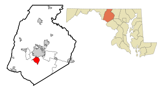
Ballenger Creek is an unincorporated community and census-designated place (CDP) in Frederick County, Maryland, United States. It is a part of the Frederick, Maryland urban area and is adjacent to Frederick's southern city limits. The CDP had a 2010 census population of 18,274.

<span class="mw-page-title-main">Brunswick, Maryland</span> City in Maryland

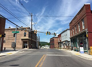
Brunswick is a city in southwestern Frederick County, Maryland, United States. The city is located on the north bank of the Potomac River; Loudoun County, Virginia occupies the opposite shore. The population of Brunswick was 8,211 at the 2022 Census. There are three schools serving Brunswick: Brunswick Elementary School, Brunswick Middle School, and Brunswick High School.

<span class="mw-page-title-main">New Market, Maryland</span> Town in Maryland

New Market is a town in Frederick County, Maryland, United States. The population was 1,525 at the 2020 census. The town bills itself as the "Antiques capital of Maryland".

<span class="mw-page-title-main">Thurmont, Maryland</span> Town in Maryland

Thurmont is a town in Frederick County, Maryland, United States. The population was 6,935 at the 2020 census. The town is located in the northern part of Frederick County, approximately ten miles from the Pennsylvania border, along U.S. Highway 15. It is very close to Cunningham Falls State Park and Catoctin Mountain Park, the latter of which contains the presidential retreat of Camp David. Thurmont is also home to Catoctin Colorfest, an arts and crafts festival that draws in about 125,000 people each autumn.

<span class="mw-page-title-main">Woodsboro, Maryland</span> Town in Maryland

Woodsboro is a town in Frederick County, Maryland, United States that was granted to Joseph Wood in 1693. The population was 1,092 at the 2020 census.

<span class="mw-page-title-main">Rock Hall, Maryland</span> Town in Maryland, United States

Rock Hall, is a waterfront town located directly on the National Chesapeake Scenic Byway in Kent County, Maryland, United States. The population was 1,310 at the 2010 census.

<span class="mw-page-title-main">Boonsboro, Maryland</span> Town in Maryland, United States

Boonsboro is a town in Washington County, Maryland, United States, located at the foot of South Mountain. It nearly borders Frederick County and is proximate to the Antietam National Battlefield. The population was 3,779 at the 2020 census.

<span class="mw-page-title-main">Rohrersville, Maryland</span> CDP in Maryland, United States

Rohrersville is a census-designated place (CDP) in Washington County, Maryland, United States. The population was 175 at the 2010 census.

<span class="mw-page-title-main">Delmar, Maryland</span> Town in Maryland, United States

Delmar is a town in Wicomico County, Maryland, United States. The population was 3,003 at the 2010 census. It is included in the Salisbury, Maryland-Delaware Metropolitan Statistical Area. When the population is added to Delmar, Delaware, the town's total population is 4,600.

<span class="mw-page-title-main">Rural Hall, North Carolina</span> Town in North Carolina, United States

Rural Hall is a town in Forsyth County, North Carolina, United States. It is a part of the Piedmont Triad. The population was 3,360 at the 2020 census. The town has one public park: Covington Memorial Park.

<span class="mw-page-title-main">Red Lion, Pennsylvania</span> Borough in Pennsylvania, United States

Red Lion is a borough in York County, Pennsylvania, United States, settled in 1852 and incorporated on January 16, 1880. The population was 6,506 at the 2020 census. It is part of the York–Hanover metropolitan area.

<span class="mw-page-title-main">Glade Spring, Virginia</span> Town in Virginia, United States

Glade Spring is a town in Washington County, Virginia, United States. The population was 1,456 at the 2010 census. It is part of the Kingsport–Bristol (TN)–Bristol (VA) Metropolitan Statistical Area, which is a component of the Johnson City–Kingsport–Bristol, TN-VA Combined Statistical Area – commonly known as the "Tri-Cities" region. I-81 runs through Glade Spring. It is located at exit 29.

<span class="mw-page-title-main">Hampstead, Maryland</span> Town in Maryland, United States

Hampstead is a town in Carroll County in the U.S. state of Maryland. The population was 6,323 at the 2010 census.

<span class="mw-page-title-main">Mount Airy, Maryland</span> Town in Maryland

Mount Airy is a town in Carroll and Frederick counties in the U.S. state of Maryland. It is part of both the Washington Metropolitan Area and Baltimore Metropolitan Area. As of the 2010 census the population was 9,288.

<span class="mw-page-title-main">Queen Anne, Maryland</span> Town in Maryland, United States of America

Queen Anne is a town in Queen Anne's and Talbot counties in the U.S. state of Maryland. The population was 222 at the 2010 census.

References

  1. 1 2 "Walkersville". Maryland Manual. Retrieved June 26, 2017.
  2. "2020 U.S. Gazetteer Files". United States Census Bureau. Retrieved April 26, 2022.
  3. 1 2 U.S. Geological Survey Geographic Names Information System: Walkersville, Maryland
  4. 1 2 "National Register Information System". National Register of Historic Places . National Park Service. April 15, 2008.
  5. "US Gazetteer files 2010". United States Census Bureau . Retrieved January 25, 2013.
  6. "Census of Population and Housing". Census.gov. Retrieved June 4, 2015.
  7. "U.S. Census website". United States Census Bureau . Retrieved January 25, 2013.
  8. Wilson, Melanie. "Town of Walkersville- Parks & Recreation" . Retrieved March 2, 2011.
  9. Wilson, Melanie. "Walkersville Southern Railroad Schedule". Walkersville Southern Railroad. Retrieved March 2, 2011.
  10. Wilson, Melanie. "Walkersville Southern Railroad Home" . Retrieved March 2, 2011.