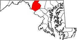
Utica, Maryland

Last updated
Utica, Maryland
Unincorporated community
USA Maryland location map.svg
Red pog.svg
Utica
Location in Maryland
Coordinates: 39°31′34″N77°23′38″W / 39.52611°N 77.39389°W / 39.52611; -77.39389 [1]
Country United States
State Maryland
County Frederick County
Elevation
[1]
367 ft (112 m)
Time zone UTC-5 (Eastern)
  Summer (DST) UTC-4 (EDT)
Area code 410 and 443
GNIS feature ID591462 [1]

Utica, also known as Utica Mills, is an unincorporated community located in Frederick County, Maryland, United States, at the intersection of Old Frederick Road and Lenhart Road. [2] [1]

It is home to St. Paul's Evangelical Lutheran Church. [3]

The Utica Covered Bridge, also known as the Utica Mills Covered Bridge, is located nearby. [4]

History

During the Civil War, the 18th Regiment Massachusetts Volunteer Infantry arrived at the outskirts of Utica on Tuesday, July 7, 1863. [5]

Dr. George F. Smith, one of the first druggists to serve Coca-Cola, and founder of the Rosebud Perfume Company in Woodsboro, Maryland, taught school in Utica for five years, before becoming a druggist in 1902. [6] [7]

Related Research Articles

<span class="mw-page-title-main">Frederick, Maryland</span> City in Maryland, United States

Frederick is a city in, and the county seat of, Frederick County, Maryland, United States. It is located at an important crossroads at the intersection of a major north–south Native American trail and east–west routes to the Chesapeake Bay, both at Baltimore and what became Washington, D.C., and across the Appalachian mountains to the Ohio River watershed. Frederick's population was 78,171 people as of the 2020 census, making it the second-largest incorporated city in Maryland behind Baltimore. It is a part of the Washington metropolitan area and the greater Washington–Baltimore combined statistical area.

<span class="mw-page-title-main">Carroll County, Maryland</span> County in Maryland, United States

Carroll County is located in the U.S. state of Maryland. As of the 2020 census, the population was 172,891. Its county seat is Westminster.

<span class="mw-page-title-main">Woodsboro, Maryland</span> Town in Maryland

Woodsboro is a town in Frederick County, Maryland, United States that was granted to Joseph Wood in 1693. The population was 1,141 at the 2010 census.

<span class="mw-page-title-main">Point of Rocks, Maryland</span> Census-designated place in Maryland, United States

Point of Rocks is an unincorporated community and census-designated place (CDP) in Frederick County, Maryland. As of the 2010 census, it had a population of 1,466.

<span class="mw-page-title-main">Jefferson, Maryland</span> Census-designated place in Maryland, United States

Jefferson is an unincorporated community and census-designated place (CDP) in Frederick County, Maryland, United States. As of the 2020 census the town had a population of 2,235. Jefferson was established in 1774 and incorporated as a town in 1831. However, a year later, in 1832, the citizens of the town decided that municipal government was unnecessary, and dis-incorporated the town, which has been unincorporated since then.

<span class="mw-page-title-main">Maryland Route 4</span> State highway in Maryland, US

Maryland Route 4 is a state highway in the U.S. state of Maryland. The highway runs 64.85 miles (104.37 km) from MD 5 in Leonardtown north to Southern Avenue in Suitland at the District of Columbia boundary, beyond which the highway continues into Washington as Pennsylvania Avenue. MD 4 is a four- to six-lane highway that connects Washington and communities around Interstate 95 (I-95)/I-495 with southern Prince George's County with southwestern Anne Arundel County. The highway is the primary highway for the length of Calvert County, during most of which the route runs concurrently with MD 2. MD 4 also connects Calvert and St. Mary's counties via the Governor Thomas Johnson Bridge across the Patuxent River. The highway connects the Southern Maryland county seats of Leonardtown, Prince Frederick, and Upper Marlboro.

<span class="mw-page-title-main">Maryland Route 355</span> State highway in Montgomery and Frederick Counties, Maryland, United States

Maryland Route 355 (MD 355) is a 36.75-mile (59.14 km) north–south road in western central Maryland in the United States. The southern terminus of the route is in Bethesda in Montgomery County, where Wisconsin Avenue meets the county's border with Washington, D.C. The northern terminus is just north of a bridge over Interstate 70 (I-70)/U.S. Route 40 (US 40) in the city of Frederick in Frederick County, where the road continues north as Market Street through Frederick towards MD 26.

<span class="mw-page-title-main">Chester Springs, Pennsylvania</span> Unincorporated community in Pennsylvania, United States

Chester Springs is an unincorporated community in Chester County, Pennsylvania, United States. It is centered on West Pikeland Township, and extends into Charlestown Township, Upper Uwchlan Township, Wallace Township, East Nantmeal Township, and West Vincent Township. The Chester Springs Historic District is located in Chester Springs.

<span class="mw-page-title-main">Lutherville, Maryland</span> Census-designated place in Maryland, United States

Lutherville is a census-designated place (CDP) in Baltimore County, Maryland, United States. As of the 2010 census it had a population of 6,504. Prior to 2010 the area was part of the Lutherville-Timonium CDP. Within its borders lies the Lutherville Historic District.

<span class="mw-page-title-main">John Christian Frederick Heyer</span> American minister and missionary

John Christian Frederick Heyer was the first missionary sent abroad by Lutherans in the United States. He founded the Guntur Mission in Andhra Pradesh, India. "Father Heyer" is commemorated as a missionary in the Calendar of Saints of the Evangelical Lutheran Church in America on November 7, along with Bartholomaeus Ziegenbalg and Ludwig Ingwer Nommensen.

<span class="mw-page-title-main">Creagerstown, Maryland</span> Unincorporated community in Maryland, United States

Creagerstown is an unincorporated community in Frederick County, Maryland, United States. It is playfully known by its residents as "4 miles from everywhere" because of its situation at 4 miles (6.4 km) from Thurmont, Woodsboro, Rocky Ridge, and Lewistown.

<span class="mw-page-title-main">Maryland Route 550</span> State highway in Maryland, United States

Maryland Route 550 is a state highway in the U.S. state of Maryland. The state highway runs 24.43 miles (39.32 km) from MD 26 in Libertytown north to Pen Mar Road in Fort Ritchie. MD 550 runs southeast–northwest across central Frederick County, connecting Fort Ritchie in the northeastern corner of Washington County and Libertytown with the towns of Thurmont and Woodsboro and the smaller communities of Creagerstown and Sabillasville. South of the highway's junction with U.S. Route 15 in Thurmont, the state highway passes through the wide valley of the Monocacy River; to the north, the highway passes along the northern edge of Catoctin Mountain and crests South Mountain near Blue Ridge Summit, Pennsylvania.

<span class="mw-page-title-main">Mount Winans, Baltimore</span> Neighborhood of Baltimore in Maryland, United States

"Mount Winans" is a mixed-use residential, commercial and industrial neighborhood in the southwestern area of the City of Baltimore in Maryland. Its north, south and east boundaries are marked by the various lines of track of the CSX Railroad. In addition, Hollins Ferry Road running to the south towards suburban Baltimore County in the southwest and further connecting with adjacent Anne Arundel County to the southeast, draws its western boundary.

Petersville is an unincorporated community in Frederick County, Maryland, United States. Petersville is located at the junction of Maryland routes 79 and 180, 1.3 miles (2.1 km) northeast of Rosemont.

<span class="mw-page-title-main">All Saints Church (Frederick, Maryland)</span> Church in Maryland, United States

All Saints Church, or All Saints Episcopal Church, founded in 1742, is a historic Episcopal church now located at 106 West Church Street in the Historic District of Frederick, Maryland. It is the seat of All Saints Parish, Diocese of Maryland, which covers most of Frederick County, Maryland and once covered most of Western Maryland.

<span class="mw-page-title-main">10th New York Cavalry Regiment</span> Military unit

The 10th New York Cavalry Regiment was a cavalry regiment that served in the Union Army during the American Civil War.

Bakersville is an unincorporated community and census-designated place in Washington County, Maryland, United States. Its population was 30 as of the 2010 census.

References

  1. 1 2 3 4 U.S. Geological Survey Geographic Names Information System: Utica, Maryland
  2. "Utica (in Frederick County, MD) Populated Place Profile". MD Home Town Locator. Retrieved June 16, 2014.
  3. "St. Paul's Evangelical Lutheran Church, Frederick Co., MD". USGenWeb Tombstone Project. Retrieved 2014-06-14.
  4. "Utica Mills Covered Bridge by Joan Carroll - Utica Mills Covered Bridge Photograph". Pixels.com. Retrieved 2014-06-14.
  5. "The Pursuit - Tuesday, July 7, 1863". Touch the Elbow - Blogging the Civil War. Retrieved 2014-06-14.
  6. "History". Rosebud Perfume Co. Retrieved 2014-06-14.
  7. "Aerial Photography Map of Utica, MD Maryland Latitude: 39.525934 , Longitude: -77.393874". www.landsat.com. Retrieved 2014-06-14.