New Site, Alabama

Last updated

New Site, Alabama
New Site Alabama.JPG
Tallapoosa County Alabama Incorporated and Unincorporated areas New Site Highlighted 0154432.svg
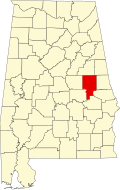
Location of New Site in Tallapoosa County, Alabama.
Coordinates: 33°1′49″N85°47′12″W / 33.03028°N 85.78667°W / 33.03028; -85.78667
Country United States
State Alabama
County Tallapoosa
Area
[1]
  Total9.88 sq mi (25.60 km2)
  Land9.87 sq mi (25.55 km2)
  Water0.02 sq mi (0.04 km2)
Elevation
886 ft (270 m)
Population
 (2020)
  Total773
  Density78.35/sq mi (30.25/km2)
Time zone UTC-6 (Central (CST))
  Summer (DST) UTC-5 (CDT)
FIPS code 01-54432
GNIS feature ID0155177
Website townofnewsite.com

New Site is a town in Tallapoosa County, Alabama, United States. It incorporated in 1965. [2] At the 2010 census the population was 773, down from 848 in 2000. It is part of the Alexander City Micropolitan Statistical Area.

Contents

New Site is the closest municipality to the Horseshoe Bend National Military Park, which commemorates the Battle of Horseshoe Bend that hastened the end of the Creek War.

Geography

New Site is located at 33°1′49″N85°47′12″W / 33.03028°N 85.78667°W / 33.03028; -85.78667 (33.030281, -85.786721). [3] According to the U.S. Census Bureau, the town has a total area of 9.8 square miles (25 km2), all land.

Demographics

Historical population
CensusPop.Note
1880 72
1970 548
1980 430−21.5%
1990 66955.6%
2000 84826.8%
2010 773−8.8%
2020 7730.0%
U.S. Decennial Census [4]
2013 Estimate [5]

As of the census [6] of 2000, there were 848 people, 339 households, and 240 families residing in the town. The population density was 86.8 inhabitants per square mile (33.5/km2). There were 376 housing units at an average density of 38.5 per square mile (14.9/km2). The racial makeup of the town was 89.27% White, 9.79% Black or African American, 0.59% Native American, 0.24% from other races, and 0.12% from two or more races. 0.47% of the population were Hispanic or Latino of any race.

There were 339 households, out of which 30.7% had children under the age of 18 living with them, 52.8% were married couples living together, 14.7% had a female householder with no husband present, and 29.2% were non-families. 26.0% of all households were made up of individuals, and 15.6% had someone living alone who was 65 years of age or older. The average household size was 2.50 and the average family size was 3.00.

In the town, the population was spread out, with 22.5% under the age of 18, 8.4% from 18 to 24, 30.2% from 25 to 44, 23.3% from 45 to 64, and 15.6% who were 65 years of age or older. The median age was 39 years. For every 100 females, there were 90.1 males. For every 100 females age 18 and over, there were 86.1 males.

The median income for a household in the town was $29,167, and the median income for a family was $37,396. Males had a median income of $25,977 versus $20,109 for females. The per capita income for the town was $14,113. About 13.3% of families and 17.6% of the population were below the poverty line, including 23.7% of those under age 18 and 15.9% of those age 65 or over.

Notable person

Related Research Articles

<span class="mw-page-title-main">Tallapoosa County, Alabama</span> County in Alabama, United States

Tallapoosa County is located in the east-central portion of the U.S. state of Alabama. As of the 2020 census, the population was 41,311. Its county seat is Dadeville. Its largest city is Alexander City.

<span class="mw-page-title-main">Malvern, Alabama</span> Town in Alabama, United States

Malvern is a town in Geneva County, Alabama, United States. It is part of the Dothan, Alabama Metropolitan Statistical Area. At the 2010 census the population was 1,448, up from 1,215 in 2000.

<span class="mw-page-title-main">Horseshoe Beach, Florida</span> Town in the state of Florida, United States

Horseshoe Beach is a town in southern Dixie County, Florida, United States. The Town of Horseshoe Beach is part of Big Bend and the Nature Coast in North Florida, along the Gulf of Mexico. The population was 165 at the 2020 census.

<span class="mw-page-title-main">Cottondale, Florida</span> City in Florida, United States

Cottondale is a city in Jackson County, Florida, United States. It is part of the Florida Panhandle and North Florida. The population was 848 at the 2020 census, down from 933 at the 2010 census.

<span class="mw-page-title-main">Oldtown, Idaho</span> City in Idaho, United States

Oldtown is a city in Bonner County, Idaho and suburb of Newport, Washington, with a population of 184 at the 2010 census. It is located on the Pend Oreille River, just east of Newport. There are no natural or physical barriers, and it is strictly a political division, separated by the straight-line state boundary. Oldtown is squeezed between this boundary to the west and the river to the east, leaving the main business district on U.S. Route 2 with only 700 feet of space in which to operate on the Idaho side. Many homes are located in the south end on the other side of the railroad, as the Pend Oreille is somewhat further away here.

<span class="mw-page-title-main">Stickney, Illinois</span> Village in Illinois, United States

Stickney is a village in Cook County, Illinois, United States. The village is named for Alpheus Beede Stickney, a railroad executive who played a central role in establishing the Clearing Industrial District. Per the 2020 census, the population was 7,110. It was well known in the 1920s and early 1930s as the home for several bordellos linked to mobster Al Capone's empire.

Albion Township is a civil township of Calhoun County in the U.S. state of Michigan. It is part of the Battle Creek, Michigan Metropolitan Statistical Area. As of the 2020 census, the township population was 1,094.

<span class="mw-page-title-main">North Towanda Township, Pennsylvania</span> Township in Pennsylvania, United States

North Towanda Township is a township in Bradford County, Pennsylvania, United States. It is part of Northeastern Pennsylvania. The population was 1,132 at the 2010 census.

<span class="mw-page-title-main">East Fairfield Township, Crawford County, Pennsylvania</span> Township in Pennsylvania, United States

East Fairfield Township is a township in Crawford County, Pennsylvania, United States. It was formed from Fairfield Township in 1869. The population was 837 at the 2020 census.

Woodland Heights is a census-designated place (CDP) in Venango County, Pennsylvania, United States. The population was 1,402 at the 2000 census.

<span class="mw-page-title-main">Cokeburg, Pennsylvania</span> Borough in Pennsylvania, United States

Cokeburg is a borough in Washington County, Pennsylvania, United States and part of the Pittsburgh metropolitan area since 1950. Founded in 1902, the population was 626 at the 2020 census.

<span class="mw-page-title-main">Snelling, South Carolina</span> Town in South Carolina, United States

Snelling is a town in Barnwell County, South Carolina, United States. The population was 274 at the 2010 census.

<span class="mw-page-title-main">Mason, Tennessee</span> Town in Tennessee, United States

Mason is a town in Tipton County, Tennessee. The population was 1,609 at the 2010 census. Mason is located along U.S. Route 70, and is home to a federal detention facility.

<span class="mw-page-title-main">South Prairie, Washington</span> Town in Washington, United States

South Prairie is a town in Pierce County, Washington, United States. The population was 373 at the 2020 census.

<span class="mw-page-title-main">Junior, West Virginia</span> Town in West Virginia, United States

Junior is a town in Barbour County, West Virginia, United States, situated along the Tygart Valley River. The population was 384 at the 2020 census.

<span class="mw-page-title-main">Carpendale, West Virginia</span> Town in West Virginia, United States

Carpendale is a town in Mineral County, West Virginia, United States, and part of the Cumberland, MD-WV Metropolitan Statistical Area'. The population was 861 at the 2020 census. Carpendale was incorporated on January 2, 1990, by the Circuit Court. The town is a combination of three subdivisions of which its name reflects: Carpenters Addition, Millerdale I, and Millerdale II. There are no stores in Carpendale and there is only one road in and out of the town.

<span class="mw-page-title-main">Lester, West Virginia</span> Town in West Virginia, United States

Lester is a town in Raleigh County, West Virginia, United States. The population was 337 at the 2020 census. The community was named after Champ Lester, a local pioneer.

<span class="mw-page-title-main">Manchester, Green Lake County, Wisconsin</span> Town in Wisconsin, United States

Manchester is a town in Green Lake County, Wisconsin, United States. The population was 848 at the 2000 census. The unincorporated community of Manchester is located in the town.

<span class="mw-page-title-main">Evansville, Wyoming</span> Town in Wyoming, United States

Evansville is a town in Natrona County, Wyoming, United States. It is part of the Casper, Wyoming Metropolitan Statistical Area. The population was 2,544 at the 2010 census.

<span class="mw-page-title-main">East Troy (town), Wisconsin</span> Civil town in Walworth County, Wisconsin

East Troy is a town in Walworth County, Wisconsin, United States. The population was 3,392 as of the 2020 census. The unincorporated communities of Hilburn, Lake Beulah, and Potter Lake are located in the town, as was the ghost town of Army Lake. East Troy is also home to several summer camps.

References

  1. "2020 U.S. Gazetteer Files". United States Census Bureau. Retrieved October 29, 2021.
  2. "New Site".
  3. "US Gazetteer files: 2010, 2000, and 1990". United States Census Bureau. February 12, 2011. Retrieved April 23, 2011.
  4. "U.S. Decennial Census". Census.gov. Retrieved June 6, 2013.
  5. "Annual Estimates of the Resident Population: April 1, 2010 to July 1, 2013" . Retrieved June 3, 2014.
  6. "U.S. Census website". United States Census Bureau . Retrieved January 31, 2008.

33°01′49″N85°47′12″W / 33.030281°N 85.786721°W / 33.030281; -85.786721