
The Alabama River, in the U.S. state of Alabama, is formed by the Tallapoosa and Coosa rivers, which unite about 6 miles (10 km) north of Montgomery, near the town of Wetumpka.
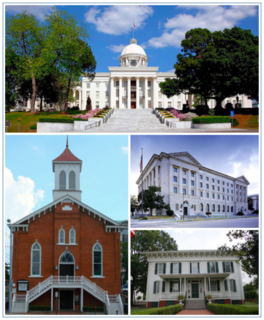
Montgomery is the capital city of the U.S. state of Alabama and the county seat of Montgomery County. Named for Richard Montgomery, it stands beside the Alabama River, on the coastal Plain of the Gulf of Mexico. In the 2010 Census, Montgomery's population was 205,764. It is the second most populous city in Alabama, after Birmingham, and is the 118th most populous in the United States. The Montgomery Metropolitan Statistical Area's population in 2010 was estimated at 374,536; it is the fourth largest in the state and 136th among United States metropolitan areas.

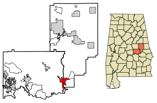
Montgomery County is located in the State of Alabama. As of the 2010 census, its population was 229,363, making it the fourth-most populous county in Alabama. Its county seat is Montgomery, the state capital.

Elmore County is a county located in the east central portion of the U.S. state of Alabama. As of the 2010 census, the population was 79,303. Its county seat is Wetumpka. Its name is in honor of General John A. Elmore.

Tallapoosa County is located in the east central portion of the U.S. state of Alabama. As of the 2010 census, the population was 41,616. Its county seat is Dadeville.
Tallassee is a city on the Tallapoosa River, located in both Elmore and Tallapoosa counties in the U.S. state of Alabama. At the 2010 census the population was 4,819. It is home to a major hydroelectric power plant at Thurlow Dam operated by Alabama Power Company.

Wetumpka is a city in and the county seat of Elmore County, Alabama, United States. At the 2010 census the population was 6,528. In the early 21st century Elmore County became one of the fastest-growing counties in the state. The city is considered part of the Montgomery Metropolitan Area.

The Battle of Horseshoe Bend, was fought during the War of 1812 in the Mississippi Territory, now central Alabama. On March 27, 1814, United States forces and Indian allies under Major General Andrew Jackson defeated the Red Sticks, a part of the Creek Indian tribe who opposed American expansion, effectively ending the Creek War.
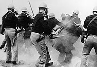
The Selma to Montgomery marches were three protest marches, held in 1965, along the 54-mile (87 km) highway from Selma, Alabama, to the state capital of Montgomery. The marches were organized by nonviolent activists to demonstrate the desire of African-American citizens to exercise their constitutional right to vote, in defiance of segregationist repression; they were part of a broader voting rights movement underway in Selma and throughout the American South. By highlighting racial injustice, they contributed to passage that year of the Voting Rights Act, a landmark federal achievement of the civil rights movement.
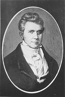
John Williams was an American lawyer, soldier, and statesman, operating primarily out of Knoxville, Tennessee, in the first part of the 19th century. He represented Tennessee in the United States Senate from 1815 to 1823, when he lost reelection to Andrew Jackson. Williams also served as colonel of the 39th U.S. Infantry Regiment during the Creek Wars, and played a key role in Jackson's victory at the Battle of Horseshoe Bend in 1814.

Horseshoe Bend National Military Park is a 2,040-acre, U.S. national military park managed by the National Park Service that is the site of the last battle of the Creek War on March 27, 1814. General Andrew Jackson's Tennessee militia, aided by the 39th U.S. Infantry Regiment and Cherokee and Lower Creek allies, won a decisive victory against the Upper Creek Red Stick Nation during the Battle of Horseshoe Bend at this site on the Tallapoosa River. Jackson's decisive victory at Horseshoe Bend broke the power of the Creek Nation.

The Coosa River is a tributary of the Alabama River in the U.S. states of Alabama and Georgia. The river is about 280 miles (450 km) long.

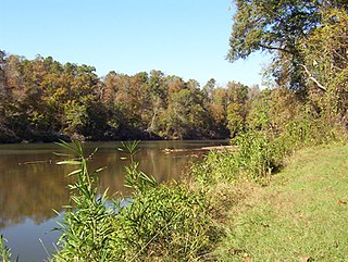
The Tallapoosa River runs 265 miles (426 km) from the southern end of the Appalachian Mountains in Georgia, United States, southward and westward into the Appalachian foothills in Alabama. It is formed by the confluence of McClendon Creek and Mud Creek in Paulding County, Georgia. Lake Martin at Alexander City, Alabama is a large and popular water recreation area formed by a dam on the river. The Tallapoosa joins the Coosa River about 10 miles (16 km) northeast of Montgomery near Wetumpka to form the Alabama River.
State Route 49 (SR 49) is an 82.684-mile-long (133.067 km) state highway in the central and eastern parts of the U.S. state of Alabama. The southern terminus of the highway is at an interchange with Interstate 85 (I-85) at Franklin in Macon County. The northern terminus of the highway is at an intersection with SR 281 east of Cheaha State Park in southern Cleburne County.

Fort Toulouse and Fort Jackson are two forts that shared the same site at the fork of the Coosa River and the Tallapoosa River, near Wetumpka, Alabama.
The Tallapoosas were a division of the Upper Creeks in the Muscogee Confederacy. Prior to Removal to Indian Territory, Tallapoosa lived along the Tallapoosa River in Alabama.
Nuyaka is a populated place in Okmulgee County, Oklahoma, United States. It is approximately 7.4 kilometres (4.6 mi) south-southwest of Beggs and is west of the city of Okmulgee off SH-56. The elevation is 735 feet (224 m) and the coordinates are latitude 35.653 and longitude -96.14. It was notable as the center of traditionalist opposition to the Creek national government during the late 19th century. Nuyaka Mission was located nearby.

Cherokee Bluffs is an unincorporated community in Tallapoosa County, Alabama, United States. The bluffs were a landmark in Tallapoosa County, and they were chosen as the first site on the Tallapoosa River for the creation of a dam and reservoir.
Fort Decatur was an earthen fort established in March 1814 on the banks of the Tallapoosa River. The fort was located on the east bank of the Tallapoosa River, near the modern community of Milstead. Fort Decatur was also located near the Creek town of Tukabatchee. It was most likely named for Stephen Decatur.


