New Woodville, Oklahoma

Last updated

New Woodville, Oklahoma
OKMap-doton-Woodville.PNG
Location of New Woodville, Oklahoma
Coordinates: 33°58′7″N96°39′15″W / 33.96861°N 96.65417°W / 33.96861; -96.65417
Country United States
State Oklahoma
County Marshall
Area
[1]
  Total0.11 sq mi (0.28 km2)
  Land0.11 sq mi (0.28 km2)
  Water0.00 sq mi (0.00 km2)
Elevation
748 ft (228 m)
Population
 (2020)
  Total60
  Density560.75/sq mi (217.08/km2)
Time zone UTC-6 (Central (CST))
  Summer (DST) UTC-5 (CDT)
FIPS code 40-82100 [2]
GNIS feature ID1100004 [3]

New Woodville is an unincorporated community in Marshall County, Oklahoma, United States. The population was 132 at the 2010 census. Proposals to annex the unincorporated areas of New Woodville and McBride on the shores of Lake Texoma were considered in the past. Listed erroneously by the Census Bureau as "Woodville" from 2000 to 1980, the town's name was corrected in Census Bureau listings in 2005. [4]

Contents

Geography

New Woodville is located at 33°58′7″N96°39′15″W / 33.96861°N 96.65417°W / 33.96861; -96.65417 (33.968724, -96.654078). [5]

According to the United States Census Bureau, the town has a total area of 0.1 square miles (0.26 km2), all land.

Armstrong Road, Durham Street, and Lee Ann Drive are north of the BNSF which do not have a bypass because they do not connect to any other streets.

Demographics

Historical population
CensusPop.Note
1910 389
1920 44313.9%
1930 353−20.3%
1940 3643.1%
1950 78−78.6%
1960 9825.6%
1970 11820.4%
1980 94−20.3%
1990 31−67.0%
2000 69122.6%
2010 13291.3%
2020 60−54.5%
U.S. Decennial Census [6]

As of the census [2] of 2000, there were 69 people, 27 households, and 18 families residing in the town. The population density was 605.8 inhabitants per square mile (233.9/km2). There were 37 housing units at an average density of 324.9 per square mile (125.4/km2). The racial makeup of the town was 98.55% White and 1.45% Native American. Hispanic or Latino of any race were 2.90% of the population.

There were 27 households, out of which 37.0% had children under the age of 18 living with them, 44.4% were married couples living together, 18.5% had a female householder with no husband present, and 33.3% were non-families. 33.3% of all households were made up of individuals, and 11.1% had someone living alone who was 65 years of age or older. The average household size was 2.56 and the average family size was 3.00.

In the town, the population was spread out, with 34.8% under the age of 18, 2.9% from 18 to 24, 33.3% from 25 to 44, 21.7% from 45 to 64, and 7.2% who were 65 years of age or older. The median age was 31 years. For every 100 females, there were 86.5 males. For every 100 females age 18 and over, there were 125.0 males.

The median income for a household in the town was $9,375, and the median income for a family was $9,375. Males had a median income of $15,625 versus $18,750 for females. The per capita income for the town was $5,438. There were 52.9% of families and 47.5% of the population living below the poverty line, including 36.8% are under age 18 and 57.1% of those over age 64.

History

An earlier Oklahoma community named Woodville was submerged in 1944 when the Red River was dammed (Denison Dam) to create Lake Texoma. [7] The drought of 2013 reduced the level of Lake Texoma sufficiently to expose some of Old Woodville's foundations and storm cellars. [8]

The original Woodville town incorporated between 1900 and 1907 and disincorporated when inundated in 1944. The community reincorporated as New Woodville town about two miles north of the original townsite also in 1944. New Woodville disincorporated for brief periods in the late 90s or the early 2000s, but has legally existed since 2002 although the town government has been inactive. [9]

Related Research Articles

<span class="mw-page-title-main">Marshall County, Oklahoma</span> County in Oklahoma, United States

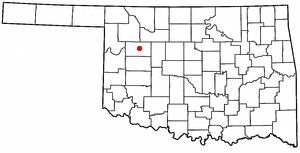
Marshall County is a county located on the south central border of Oklahoma. As of the 2020 census, the population was 15,312. Its county seat is Madill. The county was created at statehood in 1907 from the former Pickens County of the Chickasaw Nation. It was named to honor the maiden name of the mother of George Henshaw, a member of the 1906 Oklahoma Constitutional Convention. The county and its cities are part of the Texoma region.

<span class="mw-page-title-main">Love County, Oklahoma</span> County in Oklahoma, United States

Love County is a county on the southern border of the U.S. state of Oklahoma. As of the 2020 census, the population was 10,146. Its county seat is Marietta. The county was created at statehood in 1907 and named for Overton Love, a prominent Chickasaw farmer, entrepreneur and politician.

<span class="mw-page-title-main">Johnston County, Oklahoma</span> County in Oklahoma, United States

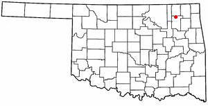
Johnston County is a county located in the U.S. state of Oklahoma. As of the 2020 census, the population was 10,272. Its county seat is Tishomingo. It was established at statehood on November 16, 1907, and named for Douglas H. Johnston, a governor of the Chickasaw Nation.

<span class="mw-page-title-main">Creek County, Oklahoma</span> County in Oklahoma, United States

Creek County is a county located in the U.S. state of Oklahoma. As of the 2020 census, the population was 71,754. Its county seat is Sapulpa.

<span class="mw-page-title-main">Bryan County, Oklahoma</span> County in Oklahoma, United States

Bryan County is a county in the U.S. state of Oklahoma. As of the 2020 census, the population was 46,067. Its county seat is Durant. It is the only county in the United States named for Democratic politician William Jennings Bryan.

<span class="mw-page-title-main">Tushka, Oklahoma</span> Town in Oklahoma, United States

Tushka is a town in Atoka County, Oklahoma, United States. The population was 312 at the 2010 census, a decline of 9.6 percent from the figure of 345 recorded in 2000.

<span class="mw-page-title-main">Armstrong, Oklahoma</span> Town in Oklahoma, United States

Armstrong is a town in Bryan County, Oklahoma, United States, along the Blue River. The population was 105 at the 2010 census, a 25.2 percent decrease from the figure of 141 recorded in 2000. The town was named for Frank C. Armstrong, a member of the Dawes Commission.

<span class="mw-page-title-main">Kenefic, Oklahoma</span> Town in Oklahoma, United States

Kenefic is a town in Bryan County, Oklahoma, United States. The population was 196 at the 2010 census, a 2 percent increase from the total of 192 recorded in 2000. The town was named for William Kenefick, president of the Missouri, Oklahoma and Gulf Railroad (MO&G), which had constructed a rail line through the region. The town name has been spelled both Kenefic and Kenefick throughout its history.

<span class="mw-page-title-main">Lawrence Creek, Oklahoma</span> Town in Oklahoma, United States

Lawrence Creek is a town in Creek County, Oklahoma, United States. Incorporated March 15, 1983, it is primarily a bedroom community whose employed residents work in Sapulpa and Tulsa. The population was 149 at the 2010 census, a gain of 25.2 percent over the figure of 119 recorded in 2000.

<span class="mw-page-title-main">Putnam, Oklahoma</span> Town in Oklahoma, United States

Putnam is a town in Dewey County, Oklahoma, United States. The population was 29 at the 2010 census, down from 46 in 2000. The community lies along U.S. Route 183.

<span class="mw-page-title-main">Taloga, Oklahoma</span> Town in Oklahoma, United States

Taloga is a town in Dewey County, Oklahoma, United States. The population was 299 at the 2010 census. It is the county seat of Dewey County. The town lies near the southern bank of a bend of the Canadian River, along U.S. Route 183, approximately thirty-seven miles north of Clinton. According to the Encyclopedia of Oklahoma History and Culture, the name is of Indian origin and means either "beautiful valley" or "rocking water".

<span class="mw-page-title-main">Tishomingo, Oklahoma</span> City in Oklahoma

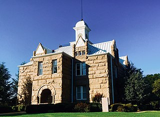
Tishomingo is the largest city in, and the county seat of, Johnston County, Oklahoma, United States. The population was 3,034 at the 2010 census, a decline of 4.1 percent from the figure of 3,162 in 2000. It was the first capital of the Chickasaw Nation, from 1856 until Oklahoma statehood in 1907. The city is home to Murray State College, a community college with an annual enrollment of 3,015 students. Tishomingo is part of the Texoma region.

<span class="mw-page-title-main">Madill, Oklahoma</span> City in Oklahoma, United States

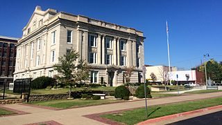
Madill is a city in and the county seat of Marshall County, Oklahoma, United States. It was named in honor of George Alexander Madill, an attorney for the St. Louis-San Francisco Railway. The population at the 2010 census was 3,770, an increase of 10.8 percent from 3,410 at the 2000 census. It is best known as the site of the annual National Sand Bass Festival. It is part of the Texoma region.

<span class="mw-page-title-main">Jamestown, Oklahoma</span> Unincorporated community in Oklahoma, United States

Jamestown is an unincorporated community in Rogers County, Oklahoma, United States. The population was 10 at the 2000 census, at which time it was a town; the community disincorporated in 1998, but the change was not reported to the Census Bureau until 2006.

<span class="mw-page-title-main">Sasakwa, Oklahoma</span> Town in Oklahoma, United States

Sasakwa is a town in Seminole County, Oklahoma, United States. The population was documented as 150 in both the 2010 and 2000 census.

<span class="mw-page-title-main">West Franklin Township, Armstrong County, Pennsylvania</span> Township in Pennsylvania, United States

West Franklin Township is a township in Armstrong County, Pennsylvania, United States. The population was 1,709 at the 2020 census, a decline from the figure of 1,853 tabulated in 2010.

<span class="mw-page-title-main">Clear Lake, South Dakota</span> City in South Dakota, United States

Clear Lake is a city in and the county seat of Deuel County, South Dakota, United States. The population was 1,218 at the 2020 census.

<span class="mw-page-title-main">South Oxford, Maine</span> Unorganized territory in Maine, United States

South Oxford is an unorganized territory located in Oxford County, Maine, United States. The population was 591 at the 2020 census. The unorganized territory encompasses the areas designated under state law as Albany Township, Mason Township, and Batchelder's Grant. Albany and Mason were formerly incorporated as towns. Albany disincorporated in 1937 while Mason disincorporated in 1935.

<span class="mw-page-title-main">Quay, Oklahoma</span> Census-designated place in Oklahoma, United States

Quay is an unincorporated community and census-designated place (CDP) located on the boundary line between Pawnee and Payne counties in the U.S. state of Oklahoma. The population was 47 at the 2000 census, when it was still a town; the community disincorporated on August 23, 2000. No population was recorded in the census of 2010.

<span class="mw-page-title-main">Winthrop (CDP), Maine</span> Census-designated place in Maine, United States

Winthrop is a census-designated place (CDP) comprising the primary settlement in the town of Winthrop in Kennebec County, Maine, United States. The population was 2,650 at the 2010 census, out of 6,092 in the town of Winthrop as a whole.

References

  1. "ArcGIS REST Services Directory". United States Census Bureau. Retrieved September 20, 2022.
  2. 1 2 "U.S. Census website". United States Census Bureau . Retrieved January 31, 2008.
  3. "US Board on Geographic Names". United States Geological Survey. October 25, 2007. Retrieved January 31, 2008.
  4. Population Estimates Boundary Changes Archived 2006-02-06 at the Wayback Machine , United States Census Bureau, 2007-07-01. Accessed 2008-11-06.
  5. "US Gazetteer files: 2010, 2000, and 1990". United States Census Bureau. February 12, 2011. Retrieved April 23, 2011.
  6. "Census of Population and Housing". Census.gov. Retrieved June 4, 2015.
  7. Michael Graczyk and Angela K. Brown (November 20, 2011). "Depleted Texas lakes expose ghost towns, graves". Kansas City Star. Retrieved November 20, 2011.
  8. KTEN. Hair, Kris. "Secrets of the Lake: Old Woodville." November 2, 2011. Retrieved September 10, 2013.
  9. "Woodville | the Encyclopedia of Oklahoma History and Culture".