Related Research Articles

Greenpoint is the northernmost neighborhood in the New York City borough of Brooklyn, in the U.S. state of New York. It is bordered on the southwest by Williamsburg at Bushwick Inlet Park and McCarren Park; on the southeast by the Brooklyn–Queens Expressway and East Williamsburg; on the north by Newtown Creek and the neighborhood of Long Island City in Queens; and on the west by the East River. The neighborhood has a large Polish immigrant and Polish-American community, containing many Polish restaurants, markets, and businesses, and it is often referred to as Little Poland.

Throggs Neck is a neighborhood and peninsula in the south-eastern portion of the borough of the Bronx in New York City. It is bounded by the East River and Long Island Sound to the south and east, Westchester Creek on the west, and Baisley Avenue and the Bruckner Expressway on the north.
Sunset Park is a neighborhood in the western part of the New York City borough of Brooklyn, bounded by Park Slope and Green-Wood Cemetery to the north, Borough Park to the east, Bay Ridge to the south, and New York Harbor to the west. The neighborhood is named for a public park of the same name that covers 24.5 acres (9.9 ha) between Fifth and Seventh Avenues from 41st to 44th Street. The area north of 36th Street is alternatively known as Greenwood Heights, while the section north of 24th Street is also called South Slope.

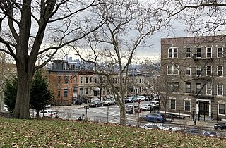
Stapleton is a neighborhood in northeastern Staten Island in New York City, United States. It is located along the waterfront of Upper New York Bay, roughly bounded on the north by Tompkinsville at Grant Street, on the south by Clifton at Vanderbilt Avenue, and on the west by St. Paul's Avenue and Van Duzer Street, which form the border with the community of Grymes Hill.

Williamsburg is a neighborhood in the New York City borough of Brooklyn, bordered by Greenpoint to the north; Bedford–Stuyvesant to the south; Bushwick and East Williamsburg to the east; and the East River to the west. It was an independent city until 1855, when it was annexed by Brooklyn; at that time, the spelling was changed from Williamsburgh to Williamsburg.
Hunts Point is a neighborhood located on a peninsula in the South Bronx of New York City. It is the location of one of the largest food distribution facilities in the world, the Hunts Point Cooperative Market. Its boundaries are the Bruckner Expressway to the west and north, the Bronx River to the east, and the East River to the south. Hunts Point Avenue is the primary street through Hunts Point.

Bath Beach is a neighborhood in the New York City borough of Brooklyn, located at the southwestern edge of the borough on Gravesend Bay. The neighborhood borders Bensonhurst and New Utrecht to the northeast across 86th Street; Dyker Beach Park and Golf Course to the northwest across 14th Avenue; and Gravesend to the east across Stillwell Avenue.

Julie Menin is a member of the New York City Council from District 5. Before she was elected to this position, she served as an American attorney, civil servant, non-profit executive, professor and small business owner. In January 2019, she was appointed Director of the Census for NYC and Executive Assistant Corporation Counsel for Strategic Advocacy. Previously, she had worked as the Commissioner of the New York City Mayor's Office of Media and Entertainment and Commissioner of New York City's Department of Consumer Affairs.
Port Morris is a mixed use, primarily industrial neighborhood geographically located in the southwest Bronx, New York City. The neighborhood is part of Bronx Community Board 1. Its boundaries are the Major Deegan Expressway and Bruckner Expressway to the north, East 149th Street to the east, the East River to the southeast, the Bronx Kill to the south, and the Harlem River to the west. Its ZIP Codes are 10451 and 10454. The neighborhood is served by the NYPD's 40th Precinct.

Vinegar Hill is a neighborhood in the borough of Brooklyn in New York City on the East River Waterfront between Dumbo and the Brooklyn Navy Yard. The neighborhood is locally governed by Brooklyn Community Board 2 and is policed by the New York City Police Department's 84th Precinct. The large Irish-American population in Vinegar Hill made it one of several New York City neighborhoods once known colloquially as Irishtown.

Castle Hill is a neighborhood located in the southeast section of the borough of the Bronx in New York City. Its boundaries are Waterbury Avenue and Westchester Avenue to the north, Westchester Creek to the east, the East River to the south, and White Plains Road to the west. Unionport is a subsection of Castle Hill, typically considered north of Lafayette Avenue.
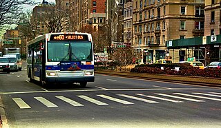
The M60 Select Bus Service is a bus route in New York City. It is part of MTA Regional Bus Operations, operated by the Manhattan and Bronx Surface Transit Operating Authority (MaBSTOA) under the New York City Transit brand. The M60 provides service between the Upper West Side of Manhattan and LaGuardia Airport in East Elmhurst, Queens, traveling between boroughs via the RFK-Triborough Bridge. It is the only direct public transit option between Manhattan and LaGuardia Airport.

Select Bus Service is a brand used by the Metropolitan Transportation Authority (MTA)'s Regional Bus Operations for limited-stop bus routes with some bus rapid transit features in New York City. The first SBS route was implemented in 2008 to improve speed and reliability on long, busy corridors.

In New York City, there is an extensive water supply system that supports several programs and infrastructure pertaining to the city's food supply. City officials, agencies, and organizations cooperate with rural farmers to grow food more locally, as well as protect waterways in the New York metropolitan area. The New York City Department of Education operates a school-time and summertime breakfast/lunch program. The city is also deprived of supermarkets in several neighborhoods, and the city government has addressed the problem by allowing extra street vendors to operate. To encourage food safety, the government also operates a restaurant-grading system that it introduced in 2010. The various food programs have made the city a model for food systems internationally.

Main Street is a major north–south street in the borough of Queens in New York City, extending from Queens Boulevard in Briarwood to Northern Boulevard in Flushing. Created in the 17th century as one of Flushing's main roads, Main Street has been lengthened at various points in its existence.

Ferry Point Park is a 413.8-acre (167.5 ha) park in the Bronx, New York City. The park site is a peninsula projecting into the East River roughly opposite the College Point and Malba neighborhoods of Queens. The park is located on the eastern shore of Westchester Creek, adjacent to the neighborhood of Throggs Neck. The park is operated by the New York City Department of Parks and Recreation. The Hutchinson River Expressway crosses the park to the Bronx-Whitestone Bridge, splitting it into east and west sides.

Since 1963, New York City has been using a system of bus lanes that are intended to give priority to buses, which contain more occupants than passenger and commercial vehicles. Most of these lanes are restricted to buses only at certain days and times, but some bus lanes are restricted 24/7. As of May 2021, there are 138.4 miles (222.7 km) of bus lanes within New York City.

The B46 bus route constitutes a public transit corridor in Brooklyn, New York City. The route runs primarily along Utica Avenue north from the Kings Plaza shopping center through Eastern Brooklyn, with continued service west along Broadway to the Williamsburg Bridge Plaza Bus Terminal. The corridor was originally served by a streetcar line, known as the Utica and Reid Avenues Line, Utica−Reid Line, Reid−Utica Line, Reid Avenue Line, or Utica Avenue Line until 1951, when the line was replaced by bus service. The bus route is operated by MTA Regional Bus Operations under the New York City Transit brand.

Calvert Vaux Park is an 85.53-acre (34.61 ha) public park in Gravesend, Brooklyn, in New York City. Created in 1934, it is composed of several disconnected sections along the Belt Parkway between Bay 44th and Bay 49th Streets. The peninsula upon which the park is located faces southwest into Gravesend Bay, immediately north of the Coney Island Creek. The park was expanded in the 1960s by waste from the construction of the Verrazzano-Narrows Bridge, and was renamed after architect Calvert Vaux in 1998. It is operated by the New York City Department of Parks and Recreation, also known as NYC Parks.