Newhall, Santa Clarita, California

Last updated
Newhall
WSHart House (cropped).jpg
William S. Hart Museum (La Loma de los Vientos)
Location map Santa Clarita.svg
Red pog.svg
Newhall
Position in Santa Clarita Valley
U.S. - Los Angeles Metropolitan Area location map.svg
Red pog.svg
Newhall
Newhall (the Los Angeles metropolitan area)
USA California location map.svg
Red pog.svg
Newhall
Newhall (California)
Coordinates: 34°23′N118°32′W / 34.38°N 118.53°W / 34.38; -118.53
Country United States of America
State California
County Los Angeles
City Santa Clarita
Elevation
[1]
1,270 ft (390 m)
Time zone UTC-8 (Pacific (PST))
  Summer (DST) UTC-7 (PDT)
ZIP Code
91321, 91350, 91351, 91355, 91387
PO box
91322
Area code 661
GNIS feature ID272642
U.S. Geological Survey Geographic Names Information System: Newhall, Santa Clarita, California

Newhall is the southernmost and oldest community in the city of Santa Clarita, California. Prior to the 1987 consolidation of Canyon Country, Saugus, Newhall, and Valencia into the city of Santa Clarita, it was an unincorporated area. It was the first permanent town in the Santa Clarita Valley.

Contents

History

Street in Newhall, 1919, showing the Hotel Swall in the middle distance on the left side of the street, the later site of the Newhall Pharmacy Newhall street (00022495).jpg
Street in Newhall, 1919, showing the Hotel Swall in the middle distance on the left side of the street, the later site of the Newhall Pharmacy

The Tataviam village of Tochonanga was located at the area where Newhall stands today. [2] Fifty villagers were brought to Mission San Fernando from 1797 to 1811. [3] Descendants of the village continued to live in the Newhall area. [4]

Named after businessman Henry Mayo Newhall, Newhall is home to the William S. Hart Regional Park, featuring tours of the famous silent movie maker's mansion. [5] Newhall is also home to the Pioneer Oil Refinery (California Historical Landmark, No. 172), the oldest surviving oil refinery in the world and the first commercially successful refinery in California. Over the years, Newhall has been the location for many movies, including Suddenly (1954) and Disney's The World's Greatest Athlete (1973). The TV-series The Magnificent Seven was also for the most part filmed in Newhall. [6]

The Lyons Station Stagecoach Stop was located at what is now Eternal Valley Cemetery near the intersection of Newhall Avenue and Sierra Highway in east Newhall. [7]

On April 6, 1970, four California Highway Patrol officers were shot dead during a traffic stop of two heavily armed career criminals. The incident was known as the Newhall incident, although it took place in present-day Valencia. [8] This led to increased emphasis on officer safety both within the CHP and nationwide.

Education

The Master's University, a non-denominational Christian liberal arts university, is located in Newhall.

At the elementary school level, Newhall is almost entirely served by the Newhall School District, except for the far northeastern portion (bordering Canyon Country) which is served by the Sulphur Springs School District. At the middle and high school levels, Newhall is served by Placerita and La Mesa Junior High Schools, and Hart and Golden Valley High Schools, all part of the William S. Hart Union High School District. [9]

Old Town Newhall

Walk of Western Stars Walk of Western Stars.jpg
Walk of Western Stars

The historic district of Old Town Newhall (a.k.a. Downtown Newhall) is a major cultural and business center. It contains many independent restaurants, stores, and theaters, as well as a public library. The areas surrounding Old Town Newhall are predominantly Hispanic, [10] and there are many Mexican restaurants. The Old Town Newhall Farmers Market is located on the grounds of the public library. Other notable sites in the area include the William S. Hart Park; Newhall DMV; Newhall Elementary School (part of the Newhall School District); Newhall Metrolink station; Veterans Historical Plaza; First Presbyterian Church of Newhall; Unity Center mosque; Newhall Community Center; and the historic Saugus Train Station (Heritage Junction). The Walk of Western Stars is also a popular attraction. The official Old Town Newhall website describes it as "Santa Clarita's premier arts and entertainment district." [11] The Hart and Main wedding and event venue is scheduled to open in spring 2022. [12] Some of the recent developments in Old Town Newhall have been described as gentrification. [13] [14]

Climate

This region experiences hot and dry summers, along with mild, rainy winters. According to the Köppen Climate Classification system, Newhall has a warm-summer Mediterranean climate, abbreviated "Csa" on climate maps. [15]

Climate data for Newhall, California (1989-1997 averages)
MonthJanFebMarAprMayJunJulAugSepOctNovDecYear
Mean daily maximum °F (°C)61.6
(16.4)
65.2
(18.4)
69.5
(20.8)
76.5
(24.7)
79.2
(26.2)
88.1
(31.2)
92.2
(33.4)
92.2
(33.4)
89.4
(31.9)
79.4
(26.3)
69.7
(20.9)
62.0
(16.7)
77.1
(25.0)
Mean daily minimum °F (°C)40.3
(4.6)
42.7
(5.9)
43.8
(6.6)
47.9
(8.8)
51.0
(10.6)
56.1
(13.4)
59.7
(15.4)
59.3
(15.2)
57.0
(13.9)
51.0
(10.6)
44.6
(7.0)
40.0
(4.4)
49.4
(9.7)
Average precipitation inches (mm)5.67
(144)
5.20
(132)
3.94
(100)
0.27
(6.9)
0.21
(5.3)
0.11
(2.8)
0.02
(0.51)
0.00
(0.00)
0.06
(1.5)
0.46
(12)
0.39
(9.9)
1.85
(47)
18.18
(461.91)
Average snowfall inches (cm)0.0
(0.0)
0.1
(0.25)
0.0
(0.0)
0.0
(0.0)
0.0
(0.0)
0.0
(0.0)
0.0
(0.0)
0.0
(0.0)
0.0
(0.0)
0.0
(0.0)
0.0
(0.0)
0.0
(0.0)
0.1
(0.25)
Source: "Western Regional Climate Center".

Notable people

See also

Related Research Articles

<span class="mw-page-title-main">Valencia, Santa Clarita, California</span> Neighborhood of Santa Clarita in Los Angeles County, California

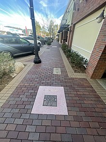
Valencia is a neighborhood in Santa Clarita located within Los Angeles County, California. It is one of the four unincorporated communities that merged to create the city of Santa Clarita in 1987. It is situated in the western part of Santa Clarita, stretching from Lyons Avenue to the south to north of Copper Hill Drive, and from Interstate 5 east to Bouquet Canyon and Seco Canyon Roads. Valencia was founded as a master-planned community with the first development, Old Orchard I, built on Lyons Avenue behind Old Orchard Elementary School.

<span class="mw-page-title-main">Santa Clarita Valley</span> Valley in Los Angeles County, California, United States

The Santa Clarita Valley (SCV) is part of the upper watershed of the Santa Clara River in Southern California. The valley was part of the 48,612-acre (19,673 ha) Rancho San Francisco Mexican land grant. Located in Los Angeles County, its main population center is the city of Santa Clarita which includes the neighborhoods of Canyon Country, Newhall, Saugus, and Valencia. Adjacent unincorporated communities include Castaic, Stevenson Ranch, Val Verde, and Valencia.

<span class="mw-page-title-main">Canyon Country, Santa Clarita, California</span> Neighborhood of Santa Clarita, California

Canyon Country is a neighborhood in the eastern part of the city of Santa Clarita, in northwestern Los Angeles County, California, United States. It lies along the Santa Clara River between the Sierra Pelona Mountains and the San Gabriel Mountains. It is the most populous of Santa Clarita's four neighborhoods.

The William S. Hart Union High School District is a school district in the Santa Clarita Valley of Los Angeles County, California. It serves all of the valley's high school students and most of its junior high school students. As of 2022–23, the total number of enrolled students was 22,469. The district's superintendent is Mike Kuhlman. The district is named after William S. Hart, one of the first western film stars, who lived in Newhall and was a local benefactor. The region served by the Hart District is also served by the Sulphur Springs, Saugus, Castaic, and Newhall elementary school districts.

<span class="mw-page-title-main">Saugus, Santa Clarita, California</span> Neighborhood of Santa Clarita in Los Angeles, California

Saugus is a neighborhood in Santa Clarita, California. It was one of four communities that merged in 1987 to create the city of Santa Clarita. Saugus includes the central and north-central portions of the city. It is named after Saugus, Massachusetts, the hometown of Henry Newhall, upon whose land the town was originally built.

The Newhall School District is an elementary school district in the Santa Clarita Valley that serves the Valencia and Newhall communities within the city of Santa Clarita, California, as well as the Stevenson Ranch community in unincorporated Los Angeles County. It currently includes ten schools.

Saugus Union School District (SUSD) is a public California school district located in Santa Clarita, Los Angeles County, California. The district serves students in grades TK/K-6 in Saugus, most of Valencia, and parts of Canyon Country. There are also pre-school programs on-site at many of the schools. The district includes 15 elementary schools.

The Sulphur Springs School District is an elementary school district in Los Angeles County, California. It serves the east side of the Santa Clarita Valley, including most of Canyon Country. As of 2023, the district has 9 elementary schools.

<span class="mw-page-title-main">Tataviam</span> Native American group in Southern California, United States

The Tataviam are a Native American group in Southern California. The ancestral land of the Tataviam people includes northwest present-day Los Angeles County and southern Ventura County, primarily in the upper basin of the Santa Clara River, the Santa Susana Mountains, and the Sierra Pelona Mountains. They are distinct from the Kitanemuk and the Gabrielino-Tongva peoples.

<span class="mw-page-title-main">Santa Clarita, California</span> City in California, United States

Santa Clarita is a city in northwestern Los Angeles County in the U.S. state of California. With a 2020 census population of 228,673, it is the third-most populous city in Los Angeles County, the 17th-most populous in California, and the 103rd-most populous city in the United States. It is located about 30 miles (48 km) northwest of downtown Los Angeles, and occupies 70.75 square miles (183.2 km2) of land in the Santa Clarita Valley, along the Santa Clara River. It is a classic example of a U.S. edge city, satellite city, or boomburb.

<span class="mw-page-title-main">City of Santa Clarita Transit</span> Public transit agency serving the Santa Clarita Valley

City of Santa Clarita Transit is a local bus service, administered by the City's transit division, that serves the City of Santa Clarita, California and nearby surrounding unincorporated areas. In 2023, the system had a ridership of 2,111,800, or about 9,000 per weekday as of the fourth quarter of 2023. Daily operations and maintenance of the fleet are under contract with MV Transportation. City of Santa Clarita Transit routes connect with services operated by Metro and Metrolink.

<span class="mw-page-title-main">Rancho San Francisco</span> Mexican land grant in present-day Los Angeles and Ventura counties, California

Rancho San Francisco was a land grant in present-day northwestern Los Angeles County and eastern Ventura County, California. It was a grant of 48,612 acres (19,673 ha) by Governor Juan B. Alvarado to Antonio del Valle, a Mexican army officer, in recognition for his service to Alta California. It is not related to the city of San Francisco.

<span class="mw-page-title-main">Henry Newhall</span> 19th century American businessman

Henry Mayo Newhall was an American businessman whose extensive land holdings became the Southern California communities of Newhall, Saugus and Valencia, and the city of Santa Clarita.

<span class="mw-page-title-main">Placerita Canyon State Park</span> State park in Los Angeles County, California, United States

Placerita Canyon State Park is a California State Park located on the north slope of the western San Gabriel Mountains, in an unincorporated rural area of Los Angeles County, near the city of Santa Clarita. The park hosts a variety of historic and natural sites, as well as serving as a trailhead for several hiking trails leading into the San Gabriel Mountains.

<span class="mw-page-title-main">Valencia, California</span> Community in Los Angeles County, California, United States

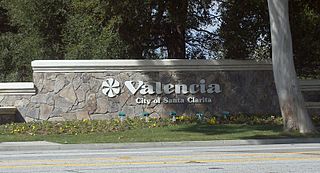
Valencia is an unincorporated community in northwestern Los Angeles County, California, United States. The area, west of Interstate 5, is expanding with residential development and already includes major commercial and industrial parks. It straddles State Route 126 and the Santa Clara River.

<span class="mw-page-title-main">Lang Southern Pacific Station</span> Historic site in Los Angeles County, California

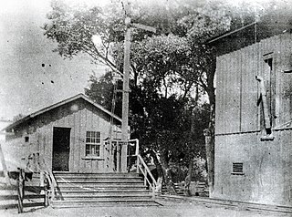
Lang Southern Pacific Station is a former Southern Pacific railway station located in Soledad Canyon near the eastern end of Santa Clarita, California. On September 5, 1876, the first railway to Los Angeles was completed at this site. The Lang Southern Pacific Station was designated a California Historic Landmark on May 22, 1957.

<span class="mw-page-title-main">Central Park (Santa Clarita)</span> Municipal park in Santa Clarita, California, United States

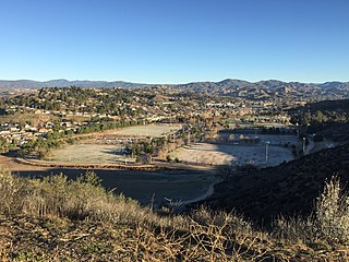
Central Park is a large municipal park located near the geographic center of Santa Clarita, California. The park was developed on 105 acres (42 ha) of land leased by the Santa Clarita Valley Water Agency to the City of Santa Clarita. It is accessible via Bouquet Canyon Road, which parallels Bouquet Creek along the northern edge of the park.

Tochonanga was a Tataviam village now located at the area of what is now Newhall, Santa Clarita, California, along the Santa Clara River. People baptized from the village were largely moved to Mission San Fernando Rey de España and referred to in mission records as Tochonabit. Current tribal president of the Fernandeño Tataviam Band of Mission Indians, Rudy Ortega Jr., is a descendant of the village.

<span class="mw-page-title-main">William S. Hart Regional Park</span> County park in Santa Clarita, California

William S. Hart Regional Park, colloquially called Hart Park, is a 265-acre county park located within the Newhall neighborhood of Santa Clarita, California.

References

Notes

  1. elevation.maplogs.com (Newhall Metrolink station)
  2. "SCVHistory.com | Tataviam Culture". scvhistory.com. Retrieved 2022-12-24. Individuals whose place of origin is identified in mission records as Tochonanga (aka Tochonàbit), a Tataviam village somewhere in the vicinity of (later) Newhall.
  3. Champagne, Duane (2021). A coalition of lineages : the Fernandeño Tataviam Band of Mission Indians. Carole E. Goldberg. Tucson. p. 25. ISBN   978-0-8165-4285-7. OCLC   1245673178.{{cite book}}: CS1 maint: location missing publisher (link)
  4. "City of Santa Clarita Public Library". Fernandeño Tataviam Band of Mission Indians. 2019.
  5. Alvarenga, Emily (2019-05-26). "The history behind the names: SCV edition". Santa Clarita Valley Signal. Retrieved 2021-03-20.
  6. Rowan, Terry (2013). The American Western A Complete Film Guide. Lulu Press, Inc. Page 252. ISBN   9781300418580.
  7. Lyons Station Stagecoach Stop – OHP
  8. "The Newhall Incident". SCV History. Retrieved 2021-02-22.
  9. "Wm. S. Hart Union High SD". SchoolSite Locator. Retrieved 2021-03-23.
  10. "The Racial Dot Map". Weldon Cooper Center for Public Service . Retrieved 2021-02-19.
  11. "Old Town Newhall". Old Town Newhall. Retrieved 2021-03-06.
  12. "Meet the Merchants of Hart and Main". Santa Clarita Magazine. 2021-05-01. Retrieved 2021-06-09.
  13. "Downtown Newhall". Gallatin Group. Retrieved 2021-03-13.
  14. "Your Tax Dollars at Work & Play". Inside SCV. April 2016. Retrieved 2021-03-13.
  15. "Newhall, California Köppen Climate Classification (Weatherbase)". Weatherbase. Retrieved 6 February 2016.
  16. "Movie Magic in Placerita Canyon" www.scvhistory (society). Melody Ranch history
  17. Klein, Gary (June 7, 2012). "UCLA's Trevor Brown is Bruins' 'Mr. Everything'". Los Angeles Times.
  18. "William S. Hart Museum".
  19. Complete Game: The Story of Andrew Lorraine, Part 1 of 3
  20. Duquette, Jim (January 22, 2015). "Ranking the top five likeliest suitors for Shields". MLB.com .