Newton, Derbyshire

Last updated

Newton
George & Dragon public house, Newton, Nottinghamshire (geograph 3254330).jpg
George & Dragon
Derbyshire UK location map.svg
Red pog.svg
Newton
Location within Derbyshire
Population4,163 for Blackwell Parish (Census 2001)
OS grid reference SK4459
  London 123 mi (198 km)
Civil parish
District
Shire county
Region
Country England
Sovereign state United Kingdom
Post town ALFRETON
Postcode district DE55
Dialling code 01773
Police Derbyshire
Fire Derbyshire
Ambulance East Midlands
UK Parliament
  • Bolsover
Website http://www.blackwellpc.org.uk/
List of places
UK
England
Derbyshire
53°07′48″N1°20′28″W / 53.130°N 1.341°W / 53.130; -1.341

Newton is a village in the civil parish of Blackwell, in the Bolsover district of Derbyshire, England, about a mile south of Tibshelf.

Contents

Other Newtons

Newton is the commonest placename in England, there being 87 in total. [1]

In the same region are:

Governance

Newton is one of the four villages (wards) that make up the civil parish of Blackwell – the other villages being Blackwell, Hilcote, and Westhouses. The Parish Council has twelve members across the four wards [2] and meets monthly.

The civil parish of Blackwell is part of the shire district of Bolsover. The parish is represented by two councillors on Bolsover District Council. [3]

The shire district of Bolsover is part of the shire county of Derbyshire. The parish is represented by one councillor on Derbyshire County Council, [4] although the electoral division covers South Normanton East and Tibshelf as well as Blackwell.

Blackwell civil parish forms part of the Bolsover parliamentary constituency. The MP currently (2010) is Dennis Skinner, who was elected MP in the 1970 general election. He has held the seat ever since.

History

Historical Timeline

Some of the main events in Newton's history are listed in the table below, in date order. The final column provides the source of the information about each event.

Newton – Historical Timeline
YearEventSource
1085Domesday Book records "Blackwelle and Neutone Leuric with Levenot". [5]
1554
Newton (Old) Hall in 2003.jpg Newton - Hall.jpg
Newton (Old) Hall in 2003.jpg
First record of Newton (Old) Hall. This is a small manor house, constructed of locally-quarried sandstone, with a stone slate roof. It is a listed building and is now a private residence. The other manor house in Newton was an older and larger building, but was demolished in 1793.
[5] and [6]
1577First record of George & Dragon ale house. [5]
1600
Red Barn Bell Pits in 2009.jpg Newton - Red Barn Bell Pits.jpg
Red Barn Bell Pits in 2009.jpg
Coal-mining in bell-pit style. The "bell pits" were where holes were dug and coal taken out so far as it was safe, then another hole was dug alongside and the earth used to fill in the previous hole. This was apparently a common method of mining in the 16th century and possibly earlier.
[5]
1754Jedediah Strutt invented "Derby Rib" process for cloth manufacture.See Notable People section.
1839Tithe map shows that Newton was an agricultural settlement based around the junction of Cragg Lane, Hall Lane and Alfreton Road, with the Old Hall as the central focus with farmsteads located around it. [7]
1851Census shows that 48 framework knitters are employed in Newton. Before the coming of the deep mines in 1868, coal-mining was done on a relatively small scale and the Blackwell area was better known as a centre for domestic framework knitting of hosiery. [8]
1868The Babbington Colliery Company opened the first deep mine at Tibshelf "Bottom Pit". This gave rise to new housing at Sherwood Street, Bamford Street, Main Street and New Street. [5] and [9]
1872Blackwell Colliery Company opened A Winning Colliery (off Fordbridge Lane). In 1875, it opened another colliery at B Winning (at Hilcote). By 1933, A Winning had 1340 employees and B Winning 727 employees. The Colliery Company also had pits at Shirland, Alfreton and Sutton. [10]
1886Opening of Tibshelf & Newton railway station. [11]
1893Opening of Great Central Railway line. [11]
1894Blackwell Parish Council first meeting. [5]
1898
Newton old school in 2010. Newton - old school.jpg
Newton old school in 2010.
School opened in former Newton Chapel. Prior to its use as a school between 1898 and 1908, this was a Primitive Methodist Chapel that was built in 1880 and enlarged in 1889. It appears to have been superseded by the larger chapel across the road in 1904. The 1938 OS map shows it in use as a hall.
[5] and [12]
1902Post office opens. [5]
1904
Methodist Chapel in 2010 Newton - Methodist Chapel.jpg
Methodist Chapel in 2010
Primitive Methodist Chapel opens. This superseded the chapel on the opposite side of Main Street – see entry for 1898 above.
[13]
1908
Newton Primary School in 2010 Newton - Primary School.JPG
Newton Primary School in 2010
Current Newton School opens. The school was designed by George H. Widdows, Derbyshire Chief Architect. Widdows was nationally acknowledged as a leading and influential designer of schools in the early twentieth century. By the time Widdows retired in 1936, he had designed some sixty elementary and seventeen secondary schools in Derbyshire. Much of the original Newton School building remains but there have been multiple alterations over the years, especially at the south end following fire damage.
[5] and [7]
1908First police officer stationed in Newton on Wire Lane. [5]
1908
Former Co-op Store in 2015. Newton - former Co-op on Newton Green.jpg
Former Co-op Store in 2015.
Co-operative Store built on Newton Green. This was a branch of the Tibshelf Equitable Co-operative Society Limited. This building has a date-stone showing "1908". A former resident of Newton recalls that, in 1936, there were 3 departments of the Co-op within this building at the corner of Littlemoor Lane and Hall Lane – these were (left to right) a drapery, a grocery and a butcher.
[14] [15]
1911Gas main laid to Newton. [5]
1911The "Coronation Palace" picture house opened. [5]
1919Church hall (now Community Centre) opened. [5]
1920First bus services. [5]
1926Coronation Palace closes. [16]
1930
Tibshelf & Newton Station in 2007 Newton - Tibshelf & Newton Station.jpg
Tibshelf & Newton Station in 2007
Closure of Tibshelf & Newton railway station.
[11]
1930Work began on constructing Whiteborough Reservoirs. Built on part of an Iron Age fort, the waterworks at the top of Newtonwood Lane (to the east of Newton village) is the water supply point for the parish of Blackwell (includes Newton). Known as Whiteborough Reservoirs, they were constructed by Eastwoods of Warsop. In October 1930, the Ministry of Health sanctioned a loan of £160,000 for a joint scheme for the benefit of Ault Hucknall, Blackwell, Glapwell, Pinxton, Pleasley, Scarcliffe, Shirebrook, South Normanton, Tibshelf and Upper Langwith. Work began in December 1930 and, on completion, each reservoir held 525,000 gallons of water. The water is pumped from Budby in Nottinghamshire to Stoney Houghton, then on to the reservoirs. To increase the supply, further reservoirs were added later. [17]
1933Tibshelf Bottom Pit closed. [9]
1937Picture House re-opens as "The Metro". [5]
1950Building of "Charnwood Crescent" housing estate. [5]
1963Closure of Tibshelf Town railway station. [11]
1966Closure of Great Central Railway line. [11]
1967Opening of M1 motorway. [18]
1969Building of "Hallfield Road" housing estate (170 dwellings). [19]
1984–1985 Miners Strike. [20]
1986Pavilion opened on sports field. [5]
1989Opening of Five Pits Trail. Five Pits Trail
1992Closure of Silverhill Colliery and associated rail link to Westhouses. [21]
1994
Newton - War Memorial and Community Centre in 2010 Newton - War Memorial and Community Centre.jpg
Newton – War Memorial and Community Centre in 2010
Community Centre opened (following purchase and renovation of former Church Hall by Parish Council). The centenary of the formation of the Parish Council in 1894 is celebrated by means of a tapestry which is on display inside the Centre.
[5]
1998Opening of Tibshelf motorway services. [22]
2002Designation of Newton Conservation Area. A conservation area is defined as "an area of special architectural or historic interest the character or appearance of which it is desirable to preserve or enhance". In Newton, the historic core of the village is considered to be a good local example of a turn-of-the twentieth-century agricultural settlement and has been largely unaltered in spite of post-war expansion. The area designated as a conservation area in 2002 is centred around the Hall Lane and Cragg Lane area. [7]
2007
Newtonwood Lane Viaduct on Silverhill Trail in 2010 Newton - Viaduct.JPG
Newtonwood Lane Viaduct on Silverhill Trail in 2010
Opening of Silverhill Trail.
[23]
2013Publication of proposed route of HS2 (high speed railway from London to Leeds). The route passes through the parish of Blackwell, just to the east of Newton and the M1 motorway. [24]
2013Planning permission granted for 49 dwellings at "Newton Fields" (off of Thurgaton Way). Planning permission was granted for a further 40 dwellings at "Newton Fields" in 2015. [25] and [26]
2015
Post Office and general store on Main Street prior to closure in 2015. Post office, Main Street, Newton, Derbyshire - Geograph-4335882.jpg
Post Office and general store on Main Street prior to closure in 2015.
Post Office relocated from Main Street to Littlemoor Lane.
Post Office and general store on Littlemoor Lane in 2015. Newton - Post Office and general store on Littlemoor Lane.jpg
Post Office and general store on Littlemoor Lane in 2015.
[27]

Shops and Services over the years

The table below shows how the number of shops and services in Newton has varied over the years. In the early 1900s, Newton was almost self-sufficient. The number of shops in each category is shown in brackets.

Newton – Shops & Services over the Years
1900 [5] 1912 [28] 1938 [29] 19802017 [27]
General store & beer-offGeneral store (9)General store (3)General store (3)
Post office & general storePost office & general storePost office & general storePost office & general storePost office & general store
GreengrocerGreengrocerGreengrocer
DraperDraper (2)Draper
General DealerGeneral Dealer
Herbalist
Carter (2)Fly proprietor
HardwareHardware
BlacksmithBlacksmith
Boot maker
Shoe repairerBoot repairerShoe repairer
Hosiery manufacture
Co-op (butchers, grocery, drapery)Co-op (butchers, grocery, drapery)
Butcher (2)Butcher (2)Butcher
Hairdresser (4)Hairdresser (3)Hairdresser (2)
Public house (2)Public house (2)Public house (3)Public house (2)
Institute & clubBilliard hall
CinemaCinema
Glass & china dealer
ConfectionerBaker
Cycle dealer
Pawnbrokers
Newsagent (2)NewsagentNewsagent
Chip shop (2)Chip shopChip shop
Chemist
Bookmaker
Coal merchant
Garage (repairs & petrol)Garage (repairs)
Craft shop
Carpet shop

Geography

Lie of the Land

Newton village centre (war memorial) is 160 metres above mean sea level, rising north-eastwards to 204 metres at the top of Newtonwood Lane (Whiteborough Hill) and dropping south-westwards to 144 metres at South Street. Newton is drained by small watercourses on both the east and west sides. Both watercourses eventually reach the River Amber at Oakerthorpe. [30]

Geology

Most of Newton lies on the Pennine Middle Coal Measures Formation bedrock. [31] This is a mix of mudstone, siltstone, sandstone and coal seams. The sandstone was used as a building material, especially during the pre-industrial era. [7] The presence of coal accounts for the growth of the population in Newton during the industrial era. The mudstone enabled many of the local collieries (including Blackwell) to manufacture their own bricks. [32] To the east, Newton is overlooked by two Nottinghamshire hills, Whiteborough Hill and Strawberry Bank, that are capped by dolomitic limestone of the Cadeby Formation. [31]

Nearby Places

Education

Places of Worship

The only church actually in Newton is the Methodist Church on Main Street. [35] The nearest Anglican church is St Werburgh's at Old Blackwell. [36] Of the original late 12th-century church, there remains but one pillar, in Transitional style, preserved on the inner face of the north wall. The tower dates from an 1828 rebuild, while the rest of the church is of 1878. In the porch is the stump of a Saxon cross. [37]

Leisure facilities

For a village of its size, Newton is fairly well-served by leisure facilities. These include:

Transport

Roads

Newton is on the B6026 road, which effectively provides a link between the villages south-east of Chesterfield and junction 28 of the M1. The M1 passes immediately to the east of Newton, although there is no direct access to the motorway. The Tibshelf motorway service area has two service entries (northbound and southbound) onto Newtonwood Lane.

Bus Services

As at February 2015, there are commercial bus services during the daytime on weekdays to Alfreton (2-per-hour), Chesterfield (hourly) and Mansfield (hourly). There are evening and Sunday services to Alfreton and Mansfield but these run less frequently and are subsidised by Derbyshire County Council.

Train Services

The local stations for Newton were closed in 1930 (Tibshelf & Newton) and in 1963 (Tibshelf Town). The nearest stations are now Alfreton, Chesterfield and Sutton Parkway.

Footpaths and Trails

Newton is linked to neighbouring villages by road-side pavements and public footpaths. Newton is close to the junction of the Five Pits Trail with the Silverhill Trail, which provide longer-distance recreational routes.

People

Jedediah Strutt - one of the key people in the Industrial Revolution, has links with Newton. He was particularly involved in the development of mechanised clothing production, setting up mills in Belper and Milford that became the prototype for mills all over the world. Although it is certain that he was born, lived and worked in the Newton area, there is some confusion over exact locations:

Sophie Baggaley - Association football goalkeeper who plays for Birmingham City L.F.C. and has represented England up to under 20 level. [45]

Related Research Articles

<span class="mw-page-title-main">Staveley, Derbyshire</span> Human settlement in England

Staveley is a town and civil parish in the Borough of Chesterfield, Derbyshire, England. Located along the banks of the River Rother. It is northeast of Chesterfield, west of Clowne, northwest of Bolsover, southwest of Worksop and southeast of Sheffield.

<span class="mw-page-title-main">Bolsover District</span> Non-metropolitan district in England

Bolsover District is a local government district in Derbyshire, England. It is named after the town of Bolsover, which is near the geographic centre of the district, but the council is based in the large village of Clowne to the north. The district also includes the town of Shirebrook and several villages and surrounding rural areas.

<span class="mw-page-title-main">South Normanton</span> Human settlement in England

South Normanton is a village and civil parish in the Bolsover District of Derbyshire, England. The population at the 2011 Census was 9,445. An ex-mining village, it is two miles east of Alfreton. The historic industries of the village were agriculture, stocking, spinning and mining. Normanton means 'the farm of the north men' or 'Northwegans'.

<span class="mw-page-title-main">Morton, Derbyshire</span> Human settlement in England

Morton is a civil parish and village, three miles north of Alfreton in North East Derbyshire, Derbyshire, England. The civil parish population at the 2011 Census was 1,195.

<span class="mw-page-title-main">Blackwell, Bolsover</span> Human settlement in England

Blackwell is a village in Derbyshire, England. The population of the civil parish at the 2011 census was 4,389. It is one of the four villages that make up the civil parish of Blackwell within the District of Bolsover - the other villages being Hilcote, Newton and Westhouses. The Parish Council meets monthly. A brief history of the Parish of Blackwell was published in 1994.

<span class="mw-page-title-main">Clowne</span> Village in Derbyshire, England

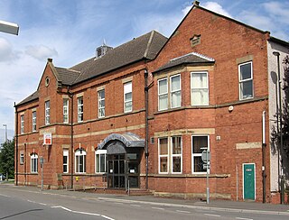
Clowne is a village and civil parish in the Bolsover district of Derbyshire, England. The population was 7,590 at the 2011 Census. It lies 9 miles (14 km) north east of Chesterfield and 7 miles (11 km) south west of Worksop and is mentioned in the Domesday Book as Clune. The name is derived from the Celtic Clun for a river.

<span class="mw-page-title-main">Tibshelf</span> Human settlement in England

Tibshelf is a village and civil parish in the Bolsover District in Derbyshire, England. Located between the towns of Clay Cross, Shirebrook, Mansfield and Chesterfield. It had a population at the 2001 UK census of 3,548, increasing to 3,787 at the 2011 Census, and increasing to 4,348 at the 2021 Census Tibshelf shares its boundaries with the villages of Morton, Pilsley, Newton, Teversal and Hardstoft.

<span class="mw-page-title-main">North Wingfield</span> Human settlement in England

North Wingfield is a large village and civil parish in the North East Derbyshire district in the county of Derbyshire, England. Located approximately 4½ miles south-east of Chesterfield, and 1 mile north-east of Clay Cross. The population of the civil parish as of the 2011 census was 6,505. The A6175 road from the M1 motorway to the A61 road runs through the village.

<span class="mw-page-title-main">Tibshelf services</span> Service area on the M1 motorway, England

Tibshelf services, opened in 1999, is a motorway service area operated by Roadchef between junctions 28 and 29 of the M1 motorway in Derbyshire, England. The site is near Tibshelf Ponds and the Five Pits Trail and lies around 23 mile (1.1 km) south-east of the village of Tibshelf, but the north-bound site is closer to the village of Newton. During the planning of the site it was originally named Chesterfield services, and during its archaeological evaluation Bronze Age flints and pottery were discovered - indicating the potential of Bronze Age enclosures in the surrounding area.

<span class="mw-page-title-main">Pilsley, North East Derbyshire</span> Human settlement in England

Pilsley is a village and civil parish in the district of North East Derbyshire in the county of Derbyshire, England. It is located near to the town of Chesterfield. At the 2011 Census the population was 3,487.

<span class="mw-page-title-main">Elmton</span> Human settlement in England

Elmton is a linear village and former civil parish, now in the parish of Elmton with Creswell in the Bolsover district of Derbyshire, England, approximately equidistant from Bolsover Castle and Creswell Crags. In 2011 the parish had a population of 5550. On 1 April 2014 the parish was abolished to form "Elmton with Creswell". However the pre 2014 parish had also sometimes been called "Elmton with Creswell".

<span class="mw-page-title-main">Astwith</span> Human settlement in England

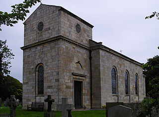
Astwith is a village in Derbyshire, England. Astwith is in the parish of Ault Hucknall. For many decades it was a part of the manor of Stainsby, which was known as Steinesbei in the Domesday survey (1087).

<span class="mw-page-title-main">New Houghton</span> Human settlement in England

New Houghton is a former mining village in the Bolsover District of Derbyshire, England, 3 miles (4.8 km) from both Bolsover and Mansfield.

Tibshelf Community School is a mixed secondary school located in Tibshelf in the English county of Derbyshire.

<span class="mw-page-title-main">Shirland and Higham</span> Civil parish in Derbyshire, England

Shirland and Higham is a civil parish within the North East Derbyshire district, which is in the county of Derbyshire, England. Mainly built up with rural fringes, its population was 4,802 residents in the 2011 census. The parish is 120 miles (190 km) north west of London, 14 miles (23 km) north east of the county city of Derby, and 1+34 miles (2.8 km) north of the nearest market town of Alfreton. It shares a boundary with the parishes of Alfreton, Blackwell, Brackenfield, Morton, South Normanton, South Wingfield, Stretton, Tibshelf and Wessington.

The Hundreds of Derbyshire were the geographic divisions of the historic county of Derbyshire for administrative, military and judicial purposes. They were established in Derbyshire some time before the Norman conquest. In the Domesday Survey of 1086 AD the hundreds were called wapentakes. By 1273 the county was divided into 8 hundreds with some later combined, becoming 6 hundreds over the following centuries. The Local Government Act 1894 replaced hundreds with districts. Derbyshire is now divided into 8 administrative boroughs within the Derbyshire County Council area.

Blackwell is a civil parish in the Bolsover District of Derbyshire, England. The parish contains eight listed buildings that are recorded in the National Heritage List for England. Of these, one is listed at Grade II*, the middle of the three grades, and the others are at Grade II, the lowest grade. The parish contains the villages of Blackwell and Newton, and the surrounding area. The listed buildings consist of houses cottages and associated structures, farmhouses, a church, and a tombstone in the churchyard.

References

  1. "Placenames of England". www.archive.org. p. 33. Retrieved 23 October 2010.
  2. "Contact Information". Blackwell Parish Council. Retrieved 26 October 2010.
  3. "Councillors". Bolsover District Council. Archived from the original on 17 May 2011. Retrieved 26 October 2010.
  4. "Councillors". Derbyshire County Council. Retrieved 26 October 2010.
  5. 1 2 3 4 5 6 7 8 9 10 11 12 13 14 15 16 17 18 19 20 21 22 The Parish and Parish Council of the Parish of Blackwell by E. Storer, 1994, registered at Stationer's Hall No B9/1200-37196.
  6. 1 2 Craven, Maxwell; Stanley, Michael (1982). The Derbyshire Country House. Derbyshire Museum Service. ISBN   0-906753-01-5.
  7. 1 2 3 4 "Newton Conservation Area appraisal and management plan" (PDF). Bolsover District Council. Archived from the original (PDF) on 23 September 2015. Retrieved 31 January 2015.
  8. Framework Knitting article by Dudley Fowkes published in the Blackwell Parish Council Magazine Spring 2013 Edition.
  9. 1 2 "platty at North Wingfield". platty. Archived from the original on 21 February 2013. Retrieved 26 October 2010.
  10. "Bulletin of the PDMHS, Volume 12, number 6, Winter 1995" (PDF). Peak District Mines Historical Society. Archived from the original (PDF) on 6 May 2012. Retrieved 9 February 2015.
  11. 1 2 3 4 5 Anderson, P. Howard (1973). Forgotten Railways: The East Midlands. David & Charles. ISBN   0-7153-6094-9.
  12. "Derbyshire Heritage Environment Record". Heritage Gateway. Retrieved 9 February 2015.
  13. Stone inscription above west window.
  14. Article "Memories of Newton from 1938" by George Hounsell published in the St Werburghs Parish Magazine of October 2010
  15. "Tibshelf Co-op Branches". Tibshelf Parish Council. Retrieved 17 April 2015.
  16. Newton Picture House article by A Cooke published in the Blackwell Parish Council Magazine Spring 2013 Edition.
  17. Article "A Bit of History – Parish Water Supply" by A Cooke published in the Blackwell Parish Council Magazine Christmas Edition 2011
  18. "the Motorway Archive". Peter Hewitt. Retrieved 26 October 2010.
  19. 1 2 "Newton Village". Derbyshire UK. Retrieved 23 October 2010.
  20. Hardy, Clive (2010). When Coal Was King. Derbyshire Times. ISBN   978-1-84547-240-5.
  21. "BBC News". BBC. 5 March 2004. Retrieved 26 October 2010.
  22. "M1 Tibshelf". Motorway Service Area Trivia. Archived from the original on 26 September 2010. Retrieved 26 October 2010.
  23. "Silverhill Trail". Mountain Bike Trails. Retrieved 26 October 2010.
  24. ARUP. "HS2 Proposed Route Map" (PDF). Department of Transport. Retrieved 10 February 2015.
  25. "Newton Fields 2013 Planning Approval" (PDF). Bolsover District Council. Retrieved 8 February 2015.
  26. "Newton Fields 2015 Planning Approval". Bolsover District Council. Retrieved 8 February 2015.
  27. 1 2 "Decision Letter re Post Office Move" (PDF). Royal Mail. Archived from the original (PDF) on 7 February 2015. Retrieved 6 February 2015.
  28. "Kellys Directory 1912". www.historicaldirectories.org. Retrieved 6 November 2010.
  29. St Werburgh's Parish Magazine October 2010, article by George Hounsell.
  30. Sheet 269 Chesterfield & Alfreton (Map) (A2 (2010) ed.). Ordnance Survey.
  31. 1 2 Sheet 112 Chesterfield (Map) (2012 ed.). British Geological Society.
  32. "Oldminer-Bricks". Oldminer. Archived from the original on 2 December 2013. Retrieved 31 January 2015.
  33. "Newton Primary School". Directgov. Retrieved 25 October 2010.[ permanent dead link ]
  34. "Tibshelf School". Directgov. Retrieved 25 October 2010.[ permanent dead link ]
  35. "Newton Methodist Church". Derby Church Net. Retrieved 25 October 2010.
  36. "Blackwell St Werburgh's Church". Derby Church Net. Retrieved 25 October 2010.
  37. "Blackwell St Werburgh's Church". Derbyshire Churches. Archived from the original on 24 July 2011. Retrieved 25 October 2010.
  38. 1 2 "Newton Community Association" (PDF). Retrieved 25 October 2010.
  39. "Newton Carnival Committee" . Retrieved 25 October 2010.
  40. "Jedediah Strutt". Spartacus Educational. Archived from the original on 4 June 2011. Retrieved 23 October 2010.
  41. "Jedediah Strutt". Derbyshire UK. Retrieved 23 October 2010.
  42. 1 2 "Timeline". Spinning Down The Derwent. Retrieved 7 November 2010.
  43. "Blackwell". Derbyshire UK. Retrieved 23 October 2010.
  44. Jedediah Strutt
  45. "Sophie Baggaley signs new contract with Blues Ladies". Birmingham City Football Club. 25 January 2016. Retrieved 22 May 2016.