Newton Highlands is one of the thirteen villages within the city of Newton in Middlesex County, Massachusetts, United States. Newton Highlands is largely suburban outside the village and the commercial district running along Winchester and Needham Streets.

The West Newton Village Center Historic District encompasses the heart of the village of West Newton, in the city of Newton, Massachusetts in the United States. It extends along Washington Street between Lucas Court in the west and Davis Court in the east, and includes a few properties on immediately adjacent side streets, including Watertown Street and Waltham Street. The village is the second-largest of Newton's commercial centers and is the best-preserved of its late 19th and early 20th century village centers. The district was listed on the National Register of Historic Places in 1990.

The West Newton Hill NR Historic District is a residential National Register historic district in the village of West Newton, in the city of Newton, Massachusetts in the United States. It is composed of a cohesive collection of spacious houses built in the second half of the 19th century, representing the development of the West Newton area as a fashionable railroad suburb. The district was listed on the National Register of Historic Places in 1986.

The Newtonville Historic District is a historic district in the village of Newtonville, in Newton, Massachusetts. The district encompasses the southern portion of the village's business district, as well as surrounding residential areas. It was listed on the National Register of Historic Places in 1986, and enlarged in 1990.

The Newton City Hall and War Memorial is a historic city hall and war memorial building located in the village of Newton Centre in Newton, Massachusetts. Built in 1932 in the Colonial Revival style, the building was designed by Allen and Collens, with landscaping by the renowned Olmsted Brothers. The building's purpose was to serve as a new city hall, and as a memorial to the city's soldiers of the First World War. On February 16, 1990, it was added to the National Register of Historic Places.

The East Cambridge Historic District encompasses the historic center of East Cambridge, Massachusetts. It includes the major buildings that were built to house county services for Middlesex County beginning in the 1810s, and a cluster of largely vernacular Greek Revival worker housing located west of the county complex on Otis, Thorndike, Spring, and Sciarappa Streets. The district was listed on the National Register of Historic Places in 1983.

The Brookfield Common Historic District encompasses a historically significant portion of the town center of Brookfield, Massachusetts. It is focused on the town common, which extends south from Main Street to Lincoln Street, and includes a dense cluster of houses on roads to its east, as well as properties on Main Street and the Post Road. The district includes more than 100 properties, including the Colonial Revival Town Hall, Banister Memorial Hall, and Romanesque Revival Congregation Church. The district was added to the National Register of Historic Places in 1990.

The Lower Highlands Historic District encompasses one of the oldest residential areas of Fall River, Massachusetts. The district is roughly bounded by Cherry, Main, Winter, and Bank Streets, and is located just east of the Downtown Fall River Historic District and directly south of the Highlands Historic District. This area was settled by 1810, has architecture tracing the city's growth as a major industrial center. The historic district was added to the National Register of Historic Places in 1984.

The Russell Center Historic District is a historic district encompassing the historic village center of Russell, Massachusetts. It is centered at the junction of Main Street and Lincoln Avenue, and is bordered by the Westfield River to the east, and the rising foothills of The Berkshires to the west. The village's 19th century development was spurred by the railroad and sustained by local papermaking businesses. It was listed on the National Register of Historic Places in 1996, and was named as one of the 1,000 places to visit in Massachusetts by the Great Places in Massachusetts Commission.

The Winchester Center Historic District encompasses the commercial and civic heart of Winchester, Massachusetts. It is roughly bounded Mt. Vernon and Washington Streets, Waterfield Road, Church and Main Streets. The district includes a number of Romanesque Revival buildings, including Winchester Town Hall and the Winchester Savings Bank building on Mount Vernon Street. Noted architects who contributed to the district include Robert Coit and Asa Fletcher. The district was listed on the National Register of Historic Places in 1986.

The Central Square Historic District is a historic district encompassing the central town common of the city of Waltham, Massachusetts, and several commercial buildings facing the common or in its immediate vicinity. The common is bounded by Carter, Moody, Main, and Elm Streets; the district includes fourteen buildings, which are located on Main, Elm, Lexington, and Church Streets, on the north and east side of the common. The district was listed on the National Register of Historic Places in 1989.
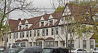
1–6 Walnut Terrace in the Newtonville village of Newton, Massachusetts is a distinctive Shingle style rowhouse. Built in 1887, it is one of the city's few examples of a 19th-century rowhouse. The building was listed on the National Register of Historic Places in 1986.

The Commonwealth Avenue Historic District of Newton, Massachusetts, encompasses roughly the eastern half of Commonwealth Avenue, extending from Waban Hill Road, near the city line with Boston, westward to Walnut Street. The roadway was laid out in 1894 and completed in 1895. Its design was influenced in part by the local residents, who were willing to give land for some of the route, and the design of Boston portions of the road, in which Frederick Law Olmsted was involved. Construction of the roadway was followed by the construction of fashionably large residences along its route, which took place mostly between the road's construction and about 1920. The district includes 188 residential properties, which are mainly built in the revival styles popular in the early 20th century. The district was added to the National Register of Historic Places in 1990.

The Farlow and Kenrick Parks Historic District is a predominantly residential historic district in the Newton Corner area of Newton, Massachusetts. The district is roughly triangular in shape, and is bounded on the north by the Massachusetts Turnpike, Park Street to the east, and Franklin and Newtonville Avenues to the west. It is roughly bisected by Church Street, and is named for two parks that are significant focal elements of the district. Kenrick Park is a small lozenge-shaped park at the southern tip of the district designed by Alexander Wadsworth; it was laid out at the request of William Kenrick, a horticulturalist whose c. 1822 Federal style house was moved to the area after the park was completed. Farlow Park is a larger rectangular park in the district's northwest, which was established by a gift from John Farlow. It is landscaped in a manner similar to the Boston Public Garden, with specimen trees and an artificial pond with bridge.

The Hyde Avenue Historic District is a residential historic district encompassing the stylistic range of houses being built in the Newton Corner area of Newton, Massachusetts in the 1880s. It includes the five houses at 36, 42, 52, 59, and 62 Hyde Avenue, The district was added to the National Register of Historic Places in 1986.

The Lasell Neighborhood Historic District is a historic district roughly bounded by Woodland and Studio Roads, Aspen and Seminary Avenue, and Grove Street in Newton, Massachusetts village of Auburndale, Massachusetts. The area includes high-quality late-19th and early-20th century housing built in the area, and includes buildings on the campus of Lasell University, established as the Auburndale Female Seminary in 1851. The district was listed on the National Register of Historic Places in 1986.

The Union Street Historic District is a historic district on Union Street between Langley Road and Herrick Road, and at 17–31 Herrick Road in Newton, Massachusetts. It encompasses the city's only significant cluster of 19th century commercial buildings. It was added to the National Register of Historic Places in 1986.

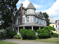
The Sumner and Gibbs Streets Historic District is a residential historic district encompassing a cohesive collection of houses representing the styles commonly built in the Newton Centre area of Newton, Massachusetts during its first period of growth. The houses are located along Sumner Street, between Cotswold Terrace and Willow Street, as well as the adjacent house at 184 Gibbs Street. The houses were built between 1865 and 1899, and are predominantly Queen Anne and Colonial Revival in styling. The district was listed on the National Register of Historic Places in 1986.

The Myrtle Baptist Church Neighborhood Historic District encompasses a historic center of the African-American community in West Newton, Massachusetts. The district includes all of Curve Street, where the Myrtle Baptist Church is located, as well as a few properties on adjacent Auburn and Prospect Streets. The district was listed on the National Register of Historic Places in 2008.

The South Middleborough Historic District encompasses the historic village center of South Middleborough, Massachusetts. The village is located about 6.5 miles (10.5 km) south of the town center, at the junction of Wareham and Locust Streets. Wareham Street, was for many years the primary route to Cape Cod, until the construction in 1966 of Massachusetts Route 24, a divided highway that bypasses the village. Partly because of the highway, the village center has not been significantly altered since that time.