Related Research Articles

Chin State is a state in western Myanmar. Chin State is bordered by Sagaing Division and Magway Division to the east, Rakhine State to the south, the Chittagong Division of Bangladesh to the west, and the Indian states of Mizoram to the west and Manipur to the north. The population of Chin State is about 478,801 according to the 2014 census. The capital of the state is Hakha. The state is a mountainous region with few transportation links. Chin State is sparsely populated and remains one of the least developed areas of the country. Chin State has the highest poverty rate of 73% as per the released figures from the first official survey. The official radio broadcasting dialect of Chin is Falam. There are 53 different subtribes and languages in Chin State. There are nine townships in Chin State: Hakha, Thantlang, Falam, Tedim, Tonzang, Matupi, Mindat, Kanpetlet and Paletwa townships. In 1896, Mindat and Kanpetlet were placed under Pakokku Hill Tracts District of British Burma later emerged into Chin Hills. Only Paletwa Township became a part of Arakan Hill Tracts of British Burma.

Myanmar is divided into twenty-one administrative subdivisions, which include 7 regions, 7 states, 1 union territory, 1 self-administered division, and 5 self-administered zones. Following is the table of government subdivisions and its organizational structure based on different regions, states, the union territory, the self-administered division, and the self-administered zones:
Falam is a town in north-western Burma (Myanmar) near Burma's western border with the Indian state of Mizoram. The town was founded by Taisun tribe. The British arrived to Falam in 1892, and became an important base for British rule of the Chin Hills. After the formation of Chin State, it was the capital city until the administrative offices were moved to Hakha in 1974. It is still the regional governor of Falam District and of Falam Township. Falam is the headquarters of several important organizations, such as the Chin Baptist Convention (CBC). The population, as of 2014, is 9,092.
Thantlang is a town and the administrative center of Thantlang Township in Chin State, western Myanmar.

Falam District is a district of the Chin State in Myanmar. It consists of 3 townships and 445 villages. The major towns include: Fort White, and Falam.

Falam Township is a township of Falam District in the Chin State of Burma (Myanmar). Its administrative seat is the town of Falam. The population, as of 2014, is 41,457. Out of this population, 9,092 live in Falam town and 32,365 live in rural areas.
The Lai people mainly inhabit the southern parts of Chin Hills in Myanmar's Chin State, in the townships of Falam, Thantlang and Hakha. They are also found in the Lawngtlai district of Mizoram, India, where they have been granted the Lai Autonomous District Council. Outside this area they are scattered in Mizoram and in Manipur. Their languages "Laizo Lai" and "Hakha Lai" are classified as Central Kuki-Chin languages.
The Daai are an ethnic group living in Chin State, Myanmar. The Daai consist of 32 Chin tribes, which have been registered by the Government of Burma since 1890. The recent Military Regime’s census mentions the Daai tribe as the 62nd of 135 tribes of Burma. Researchers refer to them as the Daai group in the ethnic survey book of Burma. The Daai Chin appear to be of Mongolian, Indo-Chinese, and Tibeto-Burman descent. The Daai people live in the Mindat, Paletwa, Matupi and Kanpetlet townships of Southern Chin State in Burma. There are more than 180 Daai villages with a total population of somewhere between 40,000 and 50,000. Their population makes the Daai-Chin the majority tribe of the Southern Chin Hills.
The Kuki-Chin languages are a branch of 50 or so Sino-Tibetan languages spoken in northeastern India, western Myanmar and southeastern Bangladesh. Most speakers of these languages are known as Mizo in Mizoram and Manipur. Also, as Kukī in Assamese and Bengali and as Chin in Burmese; some also identify as Zomi. Mizo is the most widely spoken of the Kuki-Chin languages. The Kuki-Chin language has official status in both Chin State and Mizoram as Chin and Mizo respectively.
The Lai languages or Pawih/Pawi languages are various Central Kuki-Chin-Mizo languages spoken by the Lai people or Pawi. They include “ Laiṭong” (Falam-Chin) spoken in Falam district, Laiholh (Hakha-Chin) spoken around the Haka (Hakha/Halkha) capital of Chin State in Burma (Myanmar) and in the Lawngtlai district of Mizoram, India. In Bangladesh, a related language is spoken by the Bawm people. Other Lai languages are Mi-E, and the Zokhua dialect of Hakha Lai spoken in Zokhua village.
Kale District is the westernmost district in Sagaing Division of Myanmar (Burma).
Kale Township is a township in Kale District in the Sagaing Division of Burma (Myanmar). The principal town is Kalay.
Siyin is a village in Kale Township, Kale District, in the Sagaing Region of western Burma. It is located about 10 kilometres (6.2 mi) west of Kalemyo on the Kalemyo – Theizang road. It lies at the mouth of the Siyin Valley where it debouches into the Kale Valley.

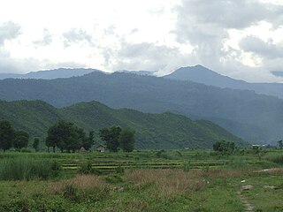
Mt. Zinghmuh is a prominent mountain that ranges from Chunchung village in Hakha Township and Ramthlo village to Falam Township. The highest peak of the range located directly above Ramthlo village in Falam Township is recorded as 8414 feet (2565m) above sea level making it the third highest peak in Chin State, Myanmar after Mt.Khonumthung (10,016 ft) also known as Nat Ma Taung or Mt. Victoria and Mt.Kennedy (8868 ft).
Lairawn Baptist Association(LBA) is a Baptist Christian denomination throughout Kalay Valley, Sagaing Division, Myanmar. The LBA mainly serves the Chin people who speak Falam dialect. It is one of the twenty eight associations of Chin Baptist Convention which is under the umbrella of Myanmar Baptist Convention (MBC). As of 2015, the association has 78 pastors and 21305 members. The association is divided into 12 areas and each area has their own by-law and constitution, but they work together with each other in unity in the context of LBA, encouraging and resourcing each other.
Chin Baptist Convention is a Baptist Christian denomination Myanmar. The headquarters is in Falam, Chin State, Myanmar. It is a member of the Myanmar Baptist Convention.
The Zanniat tribe are people of western Myanmar (Burma) who are a sub-group of the Chin peoples. The Zanniat tribe has fifty-seven sub-groupings and clans. The group's existence was recorded in Burma's 1931 census after being absent in the Chin Hills gazette of 1896. In 1943, the Zanniat tribal groups of eastern Falam Township were recorded by Henry Stevenson. The Zanniat may also be known by similar sounding names such as Zahnyiet, Zanniet, Zanngiat and Zannaing.
Rinpi, previously Rimpi, is a village in Hakha township, Chin State, Myanmar.

Za Hlei Thang was a Burmese politician who was elected Member of Parliament as the Chin National League for Democracy candidate in the 1990 Myanmar general election. After the 1990 election, he fled Burma after the State Law and Order Restoration Council accused him of breaking the 1962 Printers and Publishers Registration Act, Article 20. While in exile, he served as Chairman of the Chin League for Democracy, a "Chin party in exile". He also served as Minister of Social Welfare and Development and Minister of Health and Education at the National Coalition Government of the Union of Burma which is a "government in exile" led by Dr. Sein Win. He also served as Chairman of the Chin National Front which is a Chin insurgent group in Myanmar (Burma). He dedicated his life in the Chin national movement.
The Tashons people are ethnic tribes that live in the Falam Township, in the central part of Chin State, Myanmar. The Tashons were the most powerful tribes in the north of the Chin Hills prior to the British Empire's annexation of the region. Their influence extended over the borders of Manipur in the north, Hualngo and Lusai Hills in the west, the Phau River in the south and the Kalay-Kabaw Valley and Zanniat land in the east. They practiced a democratic system where the position of Chief was attained not by the virtue of birth but by vote of the people. The Tashons tribe and their villages were ruled by the Fahlam Council or Tashon Democratic Council, locally known as Nam Kap. The Tashons people have their own language, customs and culture.
References
- ↑ Ngawn Chin at Ethnologue (25th ed., 2022)

- Piannak Saimun. Chin State,Myanmar: Pu Sang Tin Khuai. 2013.
- The Chin Hill, Vol. I & II. Tack & Carry.
- Ngawn Land Map. Chin State, Myanmar: Pu Sang Tin Khuai. 2014.
Sino-Tibetan branches | |||||
|---|---|---|---|---|---|
| Western Himalayas (Himachal, Uttarakhand, Nepal, Sikkim) |
| 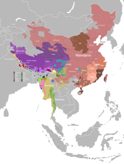 | |||
| Eastern Himalayas (Tibet, Bhutan, Arunachal) | |||||
| Myanmar and Indo-Burmese border |
| ||||
| East and Southeast Asia |
| ||||
| Dubious (possible isolates) (Arunachal) |
| ||||
| Proposed groupings | |||||
| Proto-languages | |||||
Italics indicates single languages that are also considered to be separate branches. | |||||
| | This Sino-Tibetan languages-related article is a stub. You can help Wikipedia by expanding it. |