North Terre Haute, Indiana

Last updated

North Terre Haute, Indiana
Vigo County Indiana Incorporated and Unincorporated areas North Terre Haute Highlighted 1855098.svg
Location of North Terre Haute in Vigo County, Indiana.
Coordinates: 39°31′54″N87°21′43″W / 39.53167°N 87.36194°W / 39.53167; -87.36194
Country United States
State Indiana
County Vigo
Township Otter Creek
Area
[1]
  Total3.58 sq mi (9.28 km2)
  Land3.58 sq mi (9.28 km2)
  Water0.00 sq mi (0.00 km2)
Elevation
[2]
495 ft (151 m)
Population
 (2020)
  Total4,222
  Density1,179.00/sq mi (455.19/km2)
Time zone UTC-5 (Eastern (EST))
  Summer (DST) UTC-4 (EDT)
ZIP code
47805
Area code(s) 812, 930
FIPS code 18-55098 [3]
GNIS feature ID 440299

North Terre Haute is a census-designated place (CDP) in Otter Creek Township, Vigo County, in the U.S. state of Indiana. [4] The population was 4,305 at the 2010 census. It is part of the Terre Haute Metropolitan Statistical Area.

Contents

History

A post office was established at North Terre Haute in 1912, and remained in operation until it was discontinued in 1957. [5]

Geography

North Terre Haute is located at 39°31′54″N87°21′43″W / 39.53167°N 87.36194°W / 39.53167; -87.36194 (39.531681, -87.361847). [6]

According to the United States Census Bureau, the CDP has a total area of 3.6 square miles (9.3 km2), all land.

Demographics

Historical population
CensusPop.Note
2020 4,222
U.S. Decennial Census [7]

As of the census [3] of 2000, there were 4,606 people, 1,850 households, and 1,235 families residing in the CDP. The population density was 1,287.3 inhabitants per square mile (497.0/km2). There were 1,950 housing units at an average density of 545.0 per square mile (210.4/km2). The racial makeup of the CDP was 96.18% White, 2.56% African American, 0.30% Native American, 0.35% Asian, 0.04% from other races, and 0.56% from two or more races. Hispanic or Latino of any race were 1.00% of the population.

There were 1,850 households, out of which 30.8% had children under the age of 18 living with them, 51.4% were married couples living together, 11.1% had a female householder with no husband present, and 33.2% were non-families. 27.9% of all households were made up of individuals, and 9.5% had someone living alone who was 65 years of age or older. The average household size was 2.42 and the average family size was 2.94.

In the CDP, the population was spread out, with 26.7% under the age of 18, 8.6% from 18 to 24, 29.3% from 25 to 44, 22.6% from 45 to 64, and 12.8% who were 65 years of age or older. The median age was 36 years. For every 100 females, there were 101.4 males. For every 100 females age 18 and over, there were 92.3 males.

The median income for a household in the CDP was $34,617, and the median income for a family was $42,469. Males had a median income of $33,306 versus $22,813 for females. The per capita income for the CDP was $15,729. About 8.7% of families and 9.6% of the population were below the poverty line, including 8.0% of those under age 18 and 8.7% of those age 65 or over.

Related Research Articles

<span class="mw-page-title-main">Vigo County, Indiana</span> County in Indiana, United States

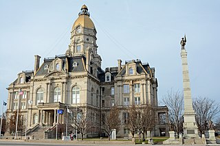
Vigo County is a county on the western border of the U.S. state of Indiana. According to the 2020 United States Census, it had a population of 105,994. Its county seat is Terre Haute.

<span class="mw-page-title-main">Goulding, Florida</span> Census-designated place in Florida, United States

Goulding is a census-designated place (CDP) in Escambia County, Florida. The population was 4,102 at the 2010 census. It is part of the Pensacola–Ferry Pass–Brent Metropolitan Statistical Area.

<span class="mw-page-title-main">Mount Plymouth, Florida</span> Census-designated place in Florida

Mount Plymouth is an unincorporated community and census-designated place (CDP) in Lake County, Florida, United States. As of the 2010 census, the CDP population was 4,011, up from 2,814 in 2000. It is part of the Orlando–Kissimmee Metropolitan Statistical Area.

<span class="mw-page-title-main">West Perrine, Florida</span> Census-designated place in Florida, United States

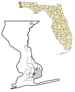
West Perrine is a census-designated place (CDP) in Miami-Dade County, Florida, United States. Prior to the 2000 census it was part of Perrine. The other part of Perrine became the East Perrine CDP for the 2000 census and is now part of the incorporated Village of Palmetto Bay. West Perrine is still an unincorporated area, although some residents have discussed the possibility of incorporating Perrine. The population was 10,602 at the 2020 census, up from 9,460 in 2010. The name derives from a land grant issued to the heirs of Henry Perrine, an agriculturist.

<span class="mw-page-title-main">Jasonville, Indiana</span> City in Indiana, United States

Jasonville is a city in Greene County, Indiana, United States. The population was 1,966 as of the 2020 census. It is the westernmost community in the Bloomington, Indiana, Metropolitan Statistical Area, approximately 15 miles closer to Terre Haute than to Bloomington.

<span class="mw-page-title-main">Farmersburg, Indiana</span> Town in Indiana, United States

Farmersburg is a town in Curry Township, Sullivan County, Indiana, United States. The population was 1,118 at the 2010 census. It is part of the Terre Haute Metropolitan Statistical Area. The town is adjacent to the Vigo County line and is overshadowed by several large TV and radio transmitter towers.

<span class="mw-page-title-main">Shelburn, Indiana</span> Town in Indiana, United States

Shelburn is a town in Curry Township, Sullivan County, in the U.S. state of Indiana. The population was 1,252 at the 2010 census. It is part of the Terre Haute Metropolitan Statistical Area.

<span class="mw-page-title-main">Sullivan, Indiana</span> City in Indiana, United States

Sullivan is a city in Hamilton Township, Sullivan County, Indiana, United States. The population was 4,249 at the 2010 census. It is part of the Terre Haute Metropolitan Statistical Area. The city is the county seat of Sullivan County.

<span class="mw-page-title-main">Riley, Indiana</span> Town in Indiana, United States

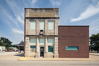
Riley, once known as Lockport, is a town in Riley Township, Vigo County, in the U.S. state of Indiana. The population was 221 at the 2010 census. It is part of the Terre Haute Metropolitan Statistical Area.

<span class="mw-page-title-main">Seelyville, Indiana</span> Town in Indiana, United States

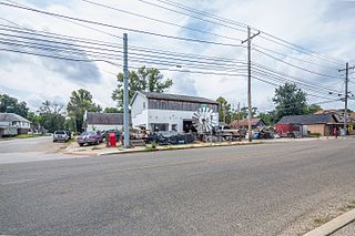
Seelyville is a town in Lost Creek Township, Vigo County, in the U.S. state of Indiana. The population was 1,029 at the 2010 census. It is part of the Terre Haute Metropolitan Statistical Area.

<span class="mw-page-title-main">West Terre Haute, Indiana</span> Town in Indiana, United States

West Terre Haute is a town in Sugar Creek Township, Vigo County, Indiana, on the western side of the Wabash River near Terre Haute. The population was 2,236 at the 2010 census. It is part of the Terre Haute Metropolitan Statistical Area. Bethany Congregational Church was placed on the National Register of Historic Places in 2003.

<span class="mw-page-title-main">Mattapoisett Center, Massachusetts</span> Census-designated place in Massachusetts, United States

Mattapoisett Center is a census-designated place (CDP) in the town of Mattapoisett in Plymouth County, Massachusetts. The population was 2,915 at the 2010 census.

Newfield is a census-designated place (CDP) in Tompkins County, New York, United States. The population was 759 at the 2010 census.

<span class="mw-page-title-main">Forestville, Ohio</span> Census-designated place in Ohio, United States

Forestville is a census-designated place (CDP) in Hamilton County, Ohio, United States. The population was 10,615 at the 2020 census.

<span class="mw-page-title-main">Pecan Plantation, Texas</span> Census-designated place in Texas, United States

Pecan Plantation is an unincorporated community and census-designated place (CDP) in southeast Hood County, Texas, United States. Its population was 5,294 at the 2010 census, up from 3,544 at the 2000 census. It is part of the Granbury, Texas, micropolitan statistical area.

<span class="mw-page-title-main">North Brookfield (CDP), Massachusetts</span> CDP in Massachusetts, United States

North Brookfield is a census-designated place (CDP) in the town of North Brookfield in Worcester County, Massachusetts, United States. The population was 2,265 at the 2010 census.

<span class="mw-page-title-main">Walworth, Wisconsin</span> Village in Wisconsin, United States

Walworth is a village in Walworth County, Wisconsin, United States. The population was 2,759 at the 2020 census. The village is located within the Town of Walworth.

<span class="mw-page-title-main">Gold Canyon, Arizona</span> CDP in Pinal County, Arizona

Gold Canyon is a census-designated place (CDP) and unincorporated community in Pinal County, Arizona, United States. The community is sometimes incorrectly called Gold Camp.

<span class="mw-page-title-main">Honey Creek Township, Vigo County, Indiana</span> Township in Indiana, United States

Honey Creek Township is one of twelve townships in Vigo County, Indiana, United States. As of the 2010 census, its population was 17,179 and it contained 6,509 housing units. It contains Terre Haute's main shopping district along U.S. Route 41 and is by far the most characteristically suburban of the twelve Vigo County townships. The population includes inmates from the Terre Haute Federal Penitentiary, located at its northwest corner.

<span class="mw-page-title-main">Lost Creek Township, Vigo County, Indiana</span> Township in Indiana, United States

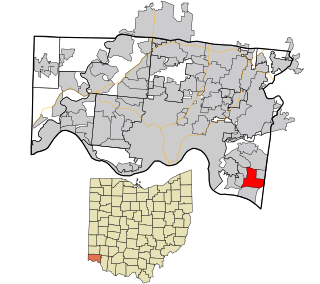
Lost Creek Township is one of twelve townships in Vigo County, Indiana, United States. As of the 2010 census, its population was 10,497 and it contained 4,236 housing units. It contains Terre Haute, Indiana's eastern, suburban end, along with the affluent Hulman family ranch and the Terre Haute International Airport originally named after the family. Seelyville, the third largest city in the county, is also located there.

References

  1. "2020 U.S. Gazetteer Files". United States Census Bureau. Retrieved March 16, 2022.
  2. "US Board on Geographic Names". United States Geological Survey. October 25, 2007. Retrieved January 31, 2008.
  3. 1 2 "U.S. Census website". United States Census Bureau . Retrieved January 31, 2008.
  4. "North Terre Haute, Indiana". Geographic Names Information System . United States Geological Survey . Retrieved August 6, 2017.
  5. "Vigo County". Jim Forte Postal History. Retrieved July 13, 2016.
  6. "US Gazetteer files: 2010, 2000, and 1990". United States Census Bureau. February 12, 2011. Retrieved April 23, 2011.
  7. "Census of Population and Housing". Census.gov. Retrieved June 4, 2016.