Muskogee County is a county located in the U.S. state of Oklahoma. As of the 2020 census, the population was 66,339. The county seat is Muskogee. The county and city were named for the Muscogee (Creek) Nation. The official spelling of the name was changed to Muskogee by the post office in 1900.

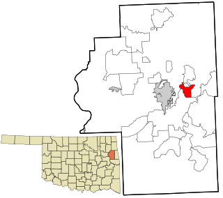
Cherokee County is a county located in the U.S. state of Oklahoma. As of the 2020 census, the population was 47,078. Its county seat is Tahlequah, which is also the capital of the Cherokee Nation.
Briggs is an unincorporated community and census-designated place (CDP) in Cherokee County, Oklahoma, United States. The population was 303 at the 2010 census.

Eldon is an unincorporated community and census-designated place (CDP) in Cherokee County, Oklahoma, United States. The population was 368 at the 2010 census, a loss of 62.3 percent from 991 at the 2000 census, due largely to shrinkage of the CDP boundaries. It lies east of Tahlequah at the junction of U.S. Highway 62 and State Highway 51. The Eldon Post Office existed from March 20, 1911, until May 30, 1936. The community is said to have been named for Eldon, Illinois.

Hulbert is a town in Cherokee County, Oklahoma, United States, named after Ben H. Hulbert, a prominent Cherokee man. The population was 483 at the 2020 census, previously it was 590 in 2010. Our Lady of the Annunciation of Clear Creek Monastery is a Benedictine monastery located in Hulbert. The Clear Creek Monastery, recently elevated to the status of an abbey, is a foundation abbey of France's Notre Dame de Fontgombault, which is itself a foundation abbey of Saint Pierre de Solesmes, also in France.

Park Hill is an unincorporated community and census-designated place (CDP) in southwestern Cherokee County, Oklahoma, United States. The population was 3,909 at the 2010 census. It lies near Tahlequah, east of the junction of U.S. Route 62 and State Highway 82.

Shady Grove is an unincorporated community and census-designated place (CDP) in Cherokee County, Oklahoma, United States. The population was 556 at the 2010 census. This is not to be confused with the similarly-named Shady Grove in McIntosh County, or the Shady Grove in Pawnee County.

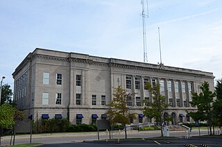
Tahlequah is a city in Cherokee County, Oklahoma located at the foothills of the Ozark Mountains. It is part of the Green Country region of Oklahoma and was established as a capital of the 19th-century Cherokee Nation in 1839, as part of the new settlement in Indian Territory after the Cherokee Native Americans were forced west from the American Southeast on the Trail of Tears.

Woodall is an unincorporated community and census-designated place (CDP) in Cherokee County, Oklahoma, United States. The population was 823 at the 2010 census.

Fort Gibson is a town in Cherokee and Muskogee counties in the U.S. state of Oklahoma. The population was 4,154 at the 2010 census, an increase of 2.5 percent over the figure of 4,054 recorded in 2000. It is the location of Fort Gibson Historical Site and Fort Gibson National Cemetery and is located near the end of the Cherokees' Trail of Tears at Tahlequah.
Peggs is an unincorporated community and census-designated place (CDP) in Cherokee County, Oklahoma, United States. It had a population of 813 at the 2010 census, compared to 814 at the 2000 census. A large minority of its residents are Native American, most of them members of 10 tribal groups such as the Cherokee Nation and the Muscogee Creek Nation.
Titanic is a census-designated place (CDP) in Adair County, Oklahoma, United States. The population was 356 at the 2010 census. It was presumably named after the famous ocean liner RMS Titanic.
Gideon is an unincorporated community and census-designated place (CDP) in Cherokee County, Oklahoma, United States. The population was 49 at the 2010 census.
Teresita is an unincorporated community and census-designated place (CDP) in Cherokee County, Oklahoma, United States. The population was 159 at the 2010 census.
Cave Spring is a census-designated place (CDP) in Adair County, Oklahoma, United States. Part of the Cherokee Nation, it was first listed as a CDP prior to the 2020 census.
Barber is an unincorporated community and census-designated place (CDP) in Cherokee County, Oklahoma, United States, in the Cherokee Nation. It was first listed as a CDP prior to the 2020 census.
Caney is a census-designated place (CDP) in Cherokee County, Oklahoma, United States, within the Cherokee Nation. It was first listed as a CDP prior to the 2020 census. It includes the unincorporated community of Tailholt.
Caney Ridge is an unincorporated community and census-designated place (CDP) in Cherokee County, Oklahoma, United States, within the Cherokee Nation. It was first listed as a CDP prior to the 2020 census.
Etta is a census-designated place (CDP) in Cherokee County, Oklahoma, United States, within the Cherokee Nation. It was first listed as a CDP prior to the 2020 census.
Pumpkin Hollow is a census-designated place (CDP) in Cherokee County, Oklahoma, United States, within the Cherokee Nation. It was first listed as a CDP prior to the 2020 census.


