
Crystal Palace is an area in South London, named after the Crystal Palace Exhibition building which stood in the area from 1854, until it was destroyed by fire in 1936. About 7 miles (11 km) southeast of Charing Cross, it includes one of the highest points in London, at 367 feet (112 m), offering views over the capital.

Muswell Hill is a suburban district of the London Borough of Haringey, north London. The hill, which reaches over 100 m (330 ft) above sea level, is situated 5+1⁄2 miles north of Charing Cross.

Penge is a suburb of South East London, England, now in the London Borough of Bromley, 3.5 miles (5.6 km) west of Bromley, 3.7 miles (6.0 km) north east of Croydon and 7.1 miles (11.4 km) south east of Charing Cross.

Sydenham is a district of south-east London, England, which is shared between the London boroughs of Lewisham, Bromley and Southwark. Prior to the creation of the County of London in 1889, Sydenham was located in Kent, bordering Surrey. Historically, the area was very affluent, with the Crystal Palace being relocated to Sydenham Hill in 1854. Today, Sydenham is a diverse area, with a population of 28,378 and borders Forest Hill, Dulwich, Crystal Palace, Penge, Beckenham, Catford and Bellingham.

West Norwood is a largely residential area of south London within the London Borough of Lambeth, located 5.4 miles (8.7 km) south south-east of Charing Cross. The centre of West Norwood sits in a bowl surrounded by hillsides on its east, west and south sides. From many parts of the area, distant views can be seen, of places such as the City of London, Canary Wharf and Crystal Palace.

Lambeth is a district in South London, England, in the London Borough of Lambeth. Lambeth was an ancient parish in the county of Surrey. It is situated 1 mile (1.6 km) south of Charing Cross, across the river from Westminster Palace. The population of the London Borough of Lambeth was 303,086 in 2011. The area experienced some slight growth in the medieval period as part of the manor of Lambeth Palace. By the Victorian era the area had seen significant development as London expanded, with dense industrial, commercial and residential buildings located adjacent to one another. The changes brought by World War II altered much of the fabric of Lambeth. Subsequent development in the late 20th and early 21st centuries has seen an increase in the number of high-rise buildings. The area is home to the International Maritime Organization. Lambeth is home to one of the largest Portuguese-speaking communities in the UK, and Portuguese is the second most commonly spoken language in Lambeth after English.

Upper Norwood is an area of south London, England, within the London Boroughs of Bromley, Croydon, Lambeth and Southwark. It is north of Croydon. The eastern part of it is better known as the Crystal Palace area. The SE19 London postcode covers the entirety of the district.

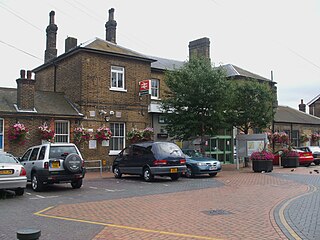
Crystal Palace railway station is a Network Rail and London Overground station in the London Borough of Bromley in south London. It is located in the Anerley area between the town centres of Crystal Palace and Penge, 8 miles 56 chains (14.0 km) from London Victoria. It is one of two stations built to serve the site of the 1851 exhibition building, the Crystal Palace, when it was moved from Hyde Park to Sydenham Hill after 1851.

Portsea Island is a flat and low-lying natural island 24.5 square kilometres in area, just off the southern coast of Hampshire in England. Portsea Island contains the majority of the city of Portsmouth.

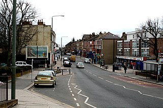
South Norwood is a district of south-east London, England, within the London Borough of Croydon, Greater London and formerly in the historic county of Surrey. It is located 7.8 miles (12.5 km) south-east of Charing Cross, north of Woodside and Addiscombe, east of Selhurst and Thornton Heath, south of Crystal Palace/Upper Norwood and Anerley, and south-west of Penge.

Sydenham is a railway station in Sydenham in the London Borough of Lewisham, South London. Originally opened in 1839, the station is located on the former Croydon Canal, which is now a branch of the Brighton Main Line, often known as the Sydenham Corridor. Sydenham falls within Travelcard Zone 3 and is served by London Overground and Southern. The station is 6 miles 32 chains down the line from London Bridge.
Norwood Junction railway station is a National Rail station in South Norwood in the London Borough of Croydon, south London, and is in Travelcard Zone 4. It is 8 miles 55 chains down the line from London Bridge.
Anerley is an area of south east London, England, within the London Borough of Bromley. It is located 7 miles (11 km) south south-east of Charing Cross, to the south of Crystal Palace and Upper Norwood, west of Penge, north of Elmers End and South Norwood.

Gipsy Hill in south London is a hilly and leafy neighbourhood spanning the southern parts of the London Boroughs of Lambeth and Southwark characterised for its stunning views of the City of London and Dulwich.

The Norwood Ridge is a 10-square-mile (26 km2) rectangular upland which occupies the geographical centre of south London, centred 5 miles (8 km) south of London Bridge. Beneath its topsoil it is a ridge of London Clay that is capped on all sides with remaining natural gravel deposits mixed with some sandy soil, which in the South Thames basin is a material known as the Claygate Beds.

Crystal Palace (High Level) was a railway station in South London. It was one of two stations built to serve the new site of the Great Exhibition building, the Crystal Palace, when it was moved from Hyde Park to Sydenham Hill after 1851. It was the terminus of the Crystal Palace and South London Junction Railway (CPSLJR), which was later absorbed by the London, Chatham and Dover Railway (LCDR). The station closed permanently in 1954.

Sydenham Hill forms part of a longer ridge and is an affluent locality in southeast London. It is also the name of a road which runs along the northeastern part of the ridge, demarcating the London Boroughs of Southwark, Bromley, and Lewisham. Its highest part is the apex of the Boroughs of Southwark and Lewisham and the 15th-highest peak in London, at 367 feet (112 m).
The A3036 is an A road in London, England, running from Waterloo to Wandsworth.

The A215 is an A road in south London, starting at Elephant and Castle and finishing around Shirley. It runs through the London Boroughs of Lambeth, Southwark and Croydon.

Elmers End is an area of south-east London, England, within the London Borough of Bromley, Greater London and formerly part of the historic county of Kent. It is located south of Beckenham, west of Eden Park, north of Monks Orchard and east of Anerley.


