The London Borough of Croydon is a London borough in south London, part of Outer London. It covers an area of 87 km2 (33.6 sq mi). It is the southernmost borough of London. At its centre is the historic town of Croydon from which the borough takes its name; while other urban centres include Coulsdon, Purley, South Norwood, Norbury, New Addington, Selsdon and Thornton Heath. Croydon is mentioned in Domesday Book, and from a small market town has expanded into one of the most populous areas on the fringe of London. The borough is now one of London's leading business, financial and cultural centres, and its influence in entertainment and the arts contribute to its status as a major metropolitan centre. Its population is 390,719, making it the largest London borough and sixteenth largest English district.

Addington is a village and area in south London, England, within the London Borough of Croydon. It is south of Spring Park, west of Coney Hall, north of New Addington and east of Forestdale and Selsdon, and is 11.1 miles (18 km) south of Charing Cross and 4 miles (6.4 km) south-east of the centre of Croydon.

Carshalton is a town, with a historic village centre, in south London, England, within the London Borough of Sutton. It is situated 9.5 miles (15.3 km) south-southwest of Charing Cross, in the valley of the River Wandle, one of the sources of which is Carshalton Ponds in the middle of the village. Prior to the creation of Greater London in 1965, Carshalton was in the administrative county of Surrey.

Coulsdon, is a town in south London, England, within the London Borough of Croydon. Coulsdon was an ancient parish in the county of Surrey that included the settlements of Purley and Kenley. It was merged with Sanderstead in 1915 to form the Coulsdon and Purley Urban District and has formed part of Greater London since 1965.

Mitcham is an area within the London Borough of Merton in Southwest London, England. It is centred 7.2 miles (11.6 km) southwest of Charing Cross. Originally a village in the county of Surrey, today it is mainly a residential suburb, and includes Mitcham Common. It has been a settlement throughout recorded history.

Morden is a district and town in south London, England, within the London Borough of Merton, in the ceremonial county of Greater London. It adjoins Merton Park and Wimbledon to the north, Mitcham to the east, Sutton to the south and Worcester Park to the west, and is around 8 miles (13 km) south-southwest of Charing Cross. Prior to the creation of Greater London in 1965, for local government purposes, Morden was in the administrative and historic county of Surrey.

Waddon is a neighbourhood in the London Borough of Croydon, at the western end of the town of Croydon. The area borders the London Borough of Sutton.

Wallington is a town in the London Borough of Sutton, South London, England, 9.7 miles (15.6 km) south-west of Charing Cross. Before the Municipal Borough of Beddington and Wallington merged into the London Borough of Sutton in Greater London in 1965, it was part of the county of Surrey. Wallington is a post town in the SM postcode area.

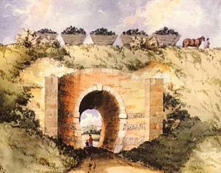
The Surrey Iron Railway (SIR) was a horse-drawn plateway that linked Wandsworth and Croydon via Mitcham, all then in Surrey but now suburbs of south London, in England. It was established by Act of Parliament in 1801, and opened partly in 1802 and partly in 1803. It was a toll railway on which carriers used horse traction. The chief goods transported were coal, building materials, lime, manure, corn and seeds. The first 8.25 miles (13.28 km) to Croydon opened on 26 July 1803, with a branch line off from Mitcham to Hackbridge.

The A24 is a major road in England that runs for 53.2 miles (85.6 km) from Clapham in south-west London to Worthing on the English Channel in West Sussex via the suburbs of south-west London, as well as through the counties of Surrey and West Sussex.

Croydon is a large town in South London, England, 9.3 miles (15.0 km) south of Charing Cross. Part of the London Borough of Croydon, a local government district of Greater London, it is one of the largest commercial districts in Greater London, with an extensive shopping district and night-time economy. The entire town had a population of 192,064 as of 2011, whilst the wider borough had a population of 384,837.

The River Wandle is a right-bank tributary of the River Thames in south London, England. With a total length of about 9 miles (14 km), the river passes through the London boroughs of Croydon, Sutton, Merton and Wandsworth, where it reaches the Thames. A short headwater – the Caterham Bourne – is partially in Surrey, the historic county of the river's catchment. Tributaries of the Wandle include Carshalton Ponds and Norbury Brook.

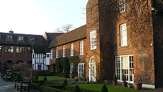
Croydon Palace, in the Old Town neighbourhood of Croydon, now part of south London, was the summer residence of the Archbishop of Canterbury for over 500 years. Regular visitors included Henry III and Queen Elizabeth I. Now known as Old Palace, the buildings are still in use as the Old Palace School, an independent girls' school of the Whitgift Foundation. It has been a grade I listed building since 1951.

South Croydon in south London is the area surrounding the valley south of central Croydon and running as far south as the former Red Deer public house on the Brighton Road. It is bounded by Waddon to the West and Selsdon and Sanderstead to the East. It is part of the South Croydon (CR2) post town and in the London Borough of Croydon.

Merton is an ancient parish historically in Surrey, but which has since 1965 been part of Greater London. It is bounded by Wimbledon to the north, Mitcham to the east, Morden, Cheam and Cuddington to the south and (New) Malden to the west. The 1871 Ordnance Survey map records its area as 1,764.7 acres (7.1 km2).

Croydon Minster is the parish and civic church of the London Borough of Croydon, located in the Old Town area of Croydon. There are currently more than 35 churches in the borough, with Croydon Minster being the most prominent. It is Grade I listed.

The London to Brighton Way, also called the London to Portslade Way, is a Roman road between Stane Street at Kennington Park and Brighton in Sussex. The road passes through Streatham and Croydon, then through the Caterham Valley gap in the North Downs. It passes through Godstone and Felbridge, then follows an almost straight line through Ardingly, Haywards Heath, Burgess Hill and Hassocks to the South Downs at Clayton. At Hassocks it crosses the Sussex Greensand Way at a large Roman cemetery. It climbs the South Downs escarpment, crossing the ridgeway and connecting with other local tracks. South of Pyecombe the route is uncertain, and may have continued to Brighton or to Portslade.

House of Reeves is an independent family-run furniture store in Croydon, southern Greater London, England, founded in 1867. It is located in the Old Town area, and gives its name to Reeves Corner, a road intersection between Church Street and Roman Way, and so to Reeves Corner tram stop.

Wandle Park is an 8.5-hectare (21-acre) park located in the Broad Green Ward of Croydon, south London, England. It was opened in 1890 by the Mayor of Croydon. The site is protected by Fields in Trust through a legal "Deed of Dedication" safeguarding the future of the space as public recreation land for future generations to enjoy.


