The London Borough of Croydon is a London borough in south London, part of Outer London. It covers an area of 87 km2 (33.6 sq mi). It is the southernmost borough of London. At its centre is the historic town of Croydon from which the borough takes its name; while other urban centres include Coulsdon, Purley, South Norwood, Norbury, New Addington, Selsdon and Thornton Heath. Croydon is mentioned in Domesday Book, and from a small market town has expanded into one of the most populous areas on the fringe of London. The borough is now one of London's leading business, financial and cultural centres, and its influence in entertainment and the arts contribute to its status as a major metropolitan centre. Its population is 390,719, making it the most populous London borough and sixteenth largest English district.

Shepherd's Bush is a suburb of West London, England, within the London Borough of Hammersmith and Fulham 4.9 miles (7.9 km) west of Charing Cross, and identified as a major metropolitan centre in the London Plan.

Crystal Palace railway station is a Network Rail and London Overground station in the London Borough of Bromley in south London. It is located in the Anerley area between the town centres of Crystal Palace and Penge, 8 miles 56 chains (14.0 km) from London Victoria. It is one of two stations built to serve the site of the 1851 exhibition building, the Crystal Palace, when it was moved from Hyde Park to Sydenham Hill after 1851.

Surrey Quays is a station on the East London Line of the London Overground. It is located in Rotherhithe, part of London Borough of Southwark; it is in Zone 2. The next station to the north is Canada Water; to the south, it splits into branches to Clapham Junction, New Cross and Crystal Palace/West Croydon. Closed in late 2007 as an underground station, it was refurbished and reopened as part of the London Overground network on 27 April 2010.

Westfield Group was an Australian shopping centre company that existed from 1960 to 2014, when it split into two independent companies: Scentre Group, which owns and operates the Australian and New Zealand Westfield shopping centre portfolio; and Westfield Corporation, which continued to own and operate the American and European centre portfolio.

Harrow is a large town in Greater London, England, and serves as the principal settlement of the London Borough of Harrow. Lying about 9.5 miles (15.3 km) north-west of Charing Cross and 5.4 miles (8.7 km) south of Watford, the entire town including its localities had a population of 149,246 at the 2011 census, whereas the wider borough had a population of 250,149.

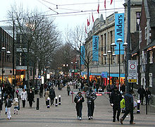
Croydon is a large town in South London, England, 9.3 miles (15.0 km) south of Charing Cross. Part of the London Borough of Croydon, a local government district of Greater London, it is one of the largest commercial districts in Greater London, with an extensive shopping district. The entire town had a population of 192,064 as of 2011, whilst the wider borough had a population of 384,837.

Peckham Rye is a railway station in Peckham town centre, South London. The station is served by Southern, London Overground, Southeastern and Thameslink.
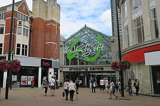
The Whitgift Centre is a large shopping centre in the town centre of Croydon, opening in stages between 1968 and 1970. The centre comprises 1,302,444 sq ft (121,001 m2) of retail space, and was the largest covered shopping development in Greater London until the opening of Westfield London at White City in 2008. The Whitgift Centre has a monthly footfall of 2.08 million. The complex includes an office development.

West Croydon is a combined railway, bus station and tram stop in Croydon, south London. It is served by National Rail, London Overground, Tramlink and London Buses services and is in Travelcard Zone 5.

Allders was an independent department store operating in the United Kingdom.
Norwood Junction railway station is a National Rail station in South Norwood in the London Borough of Croydon, south London, and is in Travelcard Zone 4. It is 8 miles 55 chains down the line from London Bridge.

Brent Cross Shopping Centre is a large shopping centre in Hendon, north London, owned by Hammerson and Abrdn. Located by the Brent Cross interchange, it opened in 1976 as the UK's first out-of-town shopping centre. Brent Cross attracted 15–16 million shoppers a year as of 2011 and has one of the largest incomes per unit area of retail space in the country.

Centrale is a shopping centre in Croydon, South London, one of the largest covered retail developments in London. It is owned and managed by Unibail-Rodamco-Westfield and was opened in 2004. Plans were announced in January 2013 to redevelop Centrale and combine it with the Whitgift Centre.
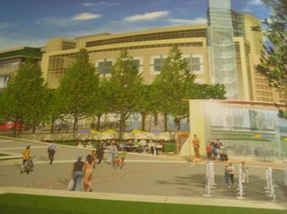
Park Place was a proposed shopping centre which had been expected to open in Croydon, London by 2011. The date was continuously pushed back due to a number of problems between different developers, financial backers and the local council. It was cancelled in 2009, as other schemes began progress, such as the extension to Centrale and the possible takeover of the Whitgift Centre by Westfield Group. Park Place was part of the Croydon Vision 2020 re-generation scheme.
Westfield London is a large shopping centre in White City, west London, England, developed by the Westfield Group at a cost of £1.6bn, on a brownfield site formerly the home of the 1908 Franco-British Exhibition. The site is bounded by the West Cross Route (A3220), the Westway (A40) and Wood Lane (A219). It opened on 30 October 2008 and became the largest covered shopping development in the capital; originally a retail floor area of 1,600,000 sq ft (150,000 m2), further investment and expansion led to it becoming the largest shopping centre in the UK and Europe by March 2018, an area of 2,600,000 sq ft (240,000 m2).

St George's Walk is a partially covered shopping parade in the centre of Croydon, London that houses many independent stores. It was completed in 1964 by Ronald Ward and Partners, the designers of St George's House, at one end of the walk, and Millbank Tower in Westminster.

Croydon, located in Greater London, England, has a diverse economy with the service and retail sectors now dominating over the town's historical market status.
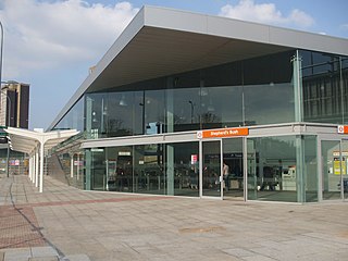
Shepherd's Bush station is a station located in the district of Shepherd's Bush in Greater London for London Overground and National Rail services.

Kennards was a small department store chain that was started in 1853, founded on the principle of selling reliable goods at low profit margins. Its main Croydon branch was notable for the full-length windows which ran the length of the store. The shop was bought out by Debenhams, through its subsidiary the Drapery Trust in 1928 but not rebranded until 1973. The site was later obtained for development for the new Drummond Centre in the 1980s and the original store was demolished. The new store was sited on some of the original footprint and anchored the Drummond Centre, which was later expanded and renamed Centrale. This store continued to anchor the centre until Debenhams announced its closure in 2020.