Ampere Way | |
|---|---|
 | |
| General information | |
| Location | Croydon, London Borough of Croydon United Kingdom |
| Operated by | Tramlink |
| Platforms | 2 |
| Construction | |
| Accessible | Yes |
| Other information | |
| Fare zone | London fare zones 3, 4, 5 and 6 |
| History | |
| Opened | 30 May 2000 |
| Passengers | |
| 2009–10 | 0.715 million total boardings and alightings [1] |
| 2010–11 | 0.803 million total boardings and alightings [2] |
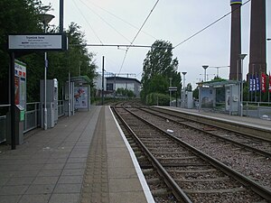
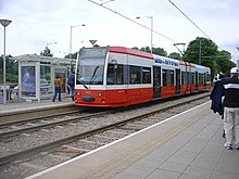
Ampere Way is a tram stop in the London Borough of Croydon,serving the Purley Way commercial area. Tramlink trams serve the stop,which is located opposite IKEA Croydon.
Contents

When the stop opened, it was named "Ampere Way" in reference to the nearby former Croydon Power Station. The two chimneys from the old power station still exist in the grounds of the IKEA store.
The station was renamed IKEA Ampere Way under a sponsorship deal [3] on 18 October 2006, in order to promote the stop's location near IKEA's Croydon store. [4] By March 2008, the station had reverted to its former name.
The tram stop is served by tram services between Elmers End/Beckenham Junction and Wimbledon.