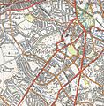
London Trams, previously Tramlink and Croydon Tramlink, is a light rail tram system serving Croydon and surrounding areas in South London, England. It began operation in 2000, the first tram system in the London region since 1952. It is managed by London Trams, a public body part of Transport for London (TfL), and has been operated by FirstGroup since 2017. Tramlink is one of two light rail networks in Greater London, the other being the Docklands Light Railway.

Mitcham Junction is a National Rail station served by Southern and Thameslink trains, and a Tramlink stop. It is in the London Borough of Merton and is in Travelcard Zone 4.
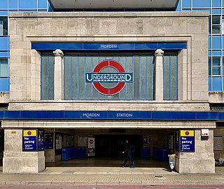
Morden is a London Underground station in Morden in the London Borough of Merton. The station is the southern terminus for the Northern line and is ironically the most southerly station on the Underground network, despite being on the Northern Line. The next station towards north is South Wimbledon. The station is located on London Road (A24), and is in Travelcard Zone 4. Nearby are Morden Hall Park and Morden Park.

Wimbledon is a National Rail, London Underground, and Tramlink station located on Wimbledon Bridge, Wimbledon in London, and is the only station in London that provides an interchange between the London Underground and Tramlink. The station serves as a junction for services from the Underground's District line and National Rail operators, as well as Tramlink services. The station is in Travelcard Zone 3. It is 7 miles 19 chains (11.6 km) from London Waterloo on the South West Main Line.

Birkbeck is a railway station and light rail stop in the London Borough of Bromley in the southern suburbs of London. On the rail network it is 10 miles 26 chains (16.6 km) measured from London Victoria. It is located on Elmers End Road (A214) and alongside Beckenham Crematorium.

South Wimbledon is a London Underground station in South Wimbledon, a suburb of Wimbledon in south-west London. The station is on the Northern line, situated between Colliers Wood and Morden stations. It is located on the corner of Merton High Street (A238) and Morden Road (A219). South Wimbledon is on the boundary between Travelcard Zone 3 and Zone 4.

West Croydon is a combined railway, bus station and tram stop in Croydon, south London. It is served by National Rail, London Overground, Tramlink and London Buses services and is in Travelcard Zone 5.

Sutton railway station (sometimes referred to as Sutton (Surrey) on tickets and timetables) is in the London Borough of Sutton in South London and is the main station serving the town of Sutton. It is served by Southern and Thameslink trains, and lies in Travelcard Zone 5, 14 miles 75 chains (14.94 miles, 24.04 km) down the line from London Bridge, measured via Forest Hill.

Lebanon Road tram stop is a light rail stop in the London Borough of Croydon in the southern suburbs of London. It serves the residential area along Addiscombe Road to the east of the centre of the town of Croydon. The stop is named after Lebanon Road, a cross-street in the vicinity of the stop.

Woodside tram stop is a light rail stop situated between Woodside Green and Ashburton Park in the London Borough of Croydon in the southern suburbs of London. The stop is located on the site of the former Woodside railway station of the Woodside and South Croydon Railway; the old station buildings survive, though not used by Tramlink.

Blackhorse Lane tram stop is a light rail stop in the London Borough of Croydon in the southern suburbs of London.

Addiscombe tram stop is a light rail stop in the London Borough of Croydon in the southern suburbs of London.
Merton Park tram stop is a stop on the Tramlink service in the London Borough of Merton.

Phipps Bridge tram stop is a stop on the Tramlink service in the London Borough of Merton. The stop is named after Phipps Bridge Road, an adjacent residential street.

Addington Village Interchange is a light rail stop and associated bus station serving Addington in the London Borough of Croydon in the southern suburbs of London. It opened on 10 May 2000 along with the line to New Addington.

Sandilands tram stop is a light rail stop in the London Borough of Croydon in the southern suburbs of London. It serves the residential area along Addiscombe Road to the east of the centre of the town of Croydon.

Beckenham Road tram stop is a light rail stop in the London Borough of Bromley in the southern suburbs of London. The stop is located on an embankment above Beckenham Road (A234) which connects Beckenham with Crystal Palace and Penge on the site of the short-lived (1858–1860) West End of London & Crystal Palace Railway Penge station.

The Sutton Loop Line, also known as the Wimbledon Loop, is a railway line that diverges from the Portsmouth Line at Streatham South junction and rejoins it near Sutton station. Trains leave southwards from Streatham to enter the loop and then return going northwards. The short section between West Sutton station and West junction is known as the "Wall of Death", possibly due to the very steep concrete walls to the cutting on both sides and the sharpness of the curve which resemble the motorcycle ride at a funfair.

The Tooting, Merton and Wimbledon Railway (TM&WR) was a railway company jointly operated by the London and South Western Railway (LSWR) and the London, Brighton and South Coast Railway (LBSCR) in Surrey.
The Sutton Link is a planned new Tramlink line or separate bus rapid transit (BRT) in London, between Wimbledon or Colliers Wood via St Helier to Sutton. As of 2020, it is the only Tramlink extension actively being pursued by the Mayor of London and TfL as part of The Mayor's Transport Strategy 2018 and the New London Plan.