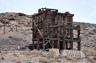
Pioneer is a ghost town in Nye County, in the U.S. state of Nevada. Beginning as a mining camp near the Mayflower and other gold mines in northern Bullfrog Hills, it became a formal town in 1908 and flourished briefly until fire destroyed much of its business district in 1909 and litigation delayed mining. Population peaked at an estimated 2,500 in 1908, and the community survived at least through the closing of the Pioneer post office in 1931. Mining continued near the town site through 1941. Few remnants of Pioneer structures survived through the end of the 20th century.
Brownsville, also known as Avalon, Esther's Place, and Anderson's Place, is an unincorporated community in Lawrence County, South Dakota, United States. The town was originally a lumber camp, and it was named for contractor David Brown. It is the nearest community to John Hill Ranch-Keltomaki, which is listed on the U.S. National Register of Historic Places.
Carbonate, also known as Carbonate Camp, West Virginia, Virginia, and Carbonate City, is a ghost town located in Lawrence County, South Dakota, United States.
Addie Camp, also known as Kennedyville, Addie Spur, or Canadaville, is a ghost town located in Pennington County, South Dakota, United States. It was a mining camp in the Black Hills that was active from the early 1880s until the 1910s.
Cambria (1889–1928) is a ghost town located in the Black Hills of Weston County, Wyoming, United States. It was a successful coal mining town for decades.

Tinton is a ghost town in the Black Hills of Lawrence County, South Dakota, United States. Founded in 1876, it started out as a gold mining camp and later began to produce tin. It had a heavy decline in the early 20th century due to the decline in the mining industry, and the town was fully abandoned by the 1950s.
Tigerville or Tiger City (1878–1885) is a ghost town in the Black Hills of Pennington County, South Dakota, United States. The old mining town exemplifies the boom-and-bust fate of many Western towns.
Flatiron, formerly known as Yellow Creek or Flat Iron City, is a ghost town in Lawrence County, South Dakota, United States. It was known for its highly successful gold mining.
Greenwood, also known as Laflin,, is a ghost town in Lawrence County, South Dakota, United States. According to the book “Deadwood Saints and Sinners” by Jerry L. Bryant and Barbara Fifer, Robert Flormann died of pneumonia in Nome, Alaska, on July 4, 1900 and is buried in Seattle, page 168.
Maitland, originally called Garden City and sometimes misspelled Midland, is a ghost town in Lawrence County, South Dakota, United States. It was a mining community that boomed during the Black Hills Gold Rush, but was abandoned by about 1915.
Rochford is an unincorporated community in Pennington County, South Dakota, United States. It is not tracked by the U.S. Census Bureau.
Roubaix, formerly known as Perry or Lewisville, is an unincorporated community in Lawrence County, South Dakota, United States. It is not monitored by the U.S. Census Bureau.
Nahant or West Nahant is a ghost town in Lawrence County, South Dakota, United States. It flourished as a logging and, to a lesser extent, mining town in the late 19th and early 20th centuries.
Sheridan, originally called Golden City, was an early mining camp in Pennington County, South Dakota, United States. It was the first county seat of Pennington County, from 1877 to 1878. It is now submerged under Sheridan Lake.
Spokane is a ghost town located in Custer County, South Dakota, United States. Founded in 1890, it was a mining camp in the Black Hills until its abandonment in the mid-20th century.
Galena is an unincorporated community in Lawrence County, South Dakota, United States. It is often considered to be a ghost town, even though a few families still live in the area. It is not tracked by the U.S. Census Bureau.

Terraville is a ghost town in Lawrence County, South Dakota, United States. It was founded in 1877 as a mining camp and later evolved into a town. It was purchased by the Homestake Mining Company and was destroyed in 1982 to make way for a new mine.
The Cripple Creek Gold Rush was a period of gold production in the Cripple Creek area from the late 1800s until the early 1900s. Mining exchanges were in Cripple Creek, Colorado Springs, Pueblo and Victor. Smelting was in Gillett, Florence, and (Old) Colorado City. Mining communities sprang up quickly, but most lasted only as long as gold continued to be produced. Settlements included:

Mystic is a ghost town in Pennington County, South Dakota. It began as a placer mining encampment called Sitting Bull in 1876, later attracting multiple railroads to the area. Its population began to decline in the early 20th century, and it now has few to no permanent residents. The old townsite was added to the National Register of Historic Places in 1986 under the name Mystic Townsite Historic District.

