The Black Hills gold rush took place in Dakota Territory in the United States. It began in 1874 following the Custer Expedition and reached a peak in 1876–77.
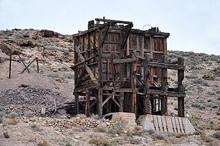
Pioneer is a ghost town in Nye County, in the U.S. state of Nevada. Beginning as a mining camp near the Mayflower and other gold mines in northern Bullfrog Hills, it became a formal town in 1908 and flourished briefly until fire destroyed much of its business district in 1909 and litigation delayed mining. Population peaked at an estimated 2,500 in 1908, and the community survived at least through the closing of the Pioneer post office in 1931. Mining continued near the town site through 1941. Few remnants of Pioneer structures survived through the end of the 20th century.
The Boston and Montana Consolidated Copper and Silver Mining Company was a mining, smelting, and refining company which operated primarily in the state of Montana in the United States. It was established in 1887 and merged with the Amalgamated Copper Company in 1901. The Amalgamated Copper Company changed its name to Anaconda Copper in 1910, and became one of America's largest corporations. Historian Michael P. Malone has written, "Well financed and well managed, the Boston and Montana came to rank among the world's greatest copper companies."
Brownsville, also known as Avalon, Esther's Place, and Anderson's Place, is an unincorporated community in Lawrence County, South Dakota, United States. The town was originally a lumber camp, and it was named for contractor David Brown. It is the nearest community to John Hill Ranch-Keltomaki, which is listed on the U.S. National Register of Historic Places.
Carbonate, also known as Carbonate Camp, West Virginia, Virginia, and Carbonate City, is a ghost town located in Lawrence County, South Dakota, United States.
Addie Camp, also known as Kennedyville, Addie Spur, or Canadaville, is a ghost town located in Pennington County, South Dakota, United States. It was a mining camp in the Black Hills that was active from the early 1880s until the 1910s.
Cambria (1889–1928) is a ghost town located in the Black Hills of Weston County, Wyoming, United States. It was a successful coal mining town for decades.

Tinton is a ghost town in the Black Hills of Lawrence County, South Dakota, United States. Founded in 1876, it started out as a gold mining camp and later began to produce tin. It had a heavy decline in the early 20th century due to the decline in the mining industry, and the town was fully abandoned by the 1950s.
Greenwood, also known as Laflin,, is a ghost town in Lawrence County, South Dakota, United States. According to the book “Deadwood Saints and Sinners” by Jerry L. Bryant and Barbara Fifer, Robert Flormann died of pneumonia in Nome, Alaska, on July 4, 1900 and is buried in Seattle, page 168.
Maitland, originally called Garden City and sometimes misspelled Midland, is a ghost town in Lawrence County, South Dakota, United States. It was a mining community that boomed during the Black Hills Gold Rush, but was abandoned by about 1915.
Rochford is an unincorporated community in Pennington County, South Dakota, United States. It is not tracked by the U.S. Census Bureau.
Roubaix, formerly known as Perry or Lewisville, is an unincorporated community in Lawrence County, South Dakota, United States. It is not monitored by the U.S. Census Bureau.
Spokane is a ghost town located in Custer County, South Dakota, United States. Founded in 1890, it was a mining camp in the Black Hills until its abandonment in the mid-20th century.
Galena is an unincorporated community in Lawrence County, South Dakota, United States. It is often considered to be a ghost town, even though a few families still live in the area. It is not tracked by the U.S. Census Bureau.
Novak, also known as Cindell Spur, is a ghost town in Lawrence County, South Dakota, United States. It was an early mining camp.

Silver Bell is a ghost town in the Silver Bell Mountains in Pima County, Arizona, United States. The name "Silver Bell" refers to a more recent ghost town, which was established in 1954 and abandoned in 1984. The original town, established in 1904, was named "Silverbell" and abandoned in the early 1930s. Both towns were utilized and later abandoned due to the mining of copper in the area.
Terry is an unincorporated community in Lawrence County, South Dakota, United States.

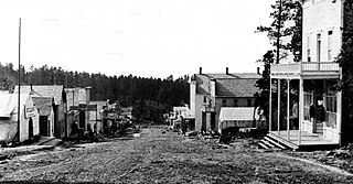
Mystic is a ghost town in Pennington County, in the U.S. state of South Dakota. It began as a placer mining encampment called Sitting Bull in 1876, later attracting multiple railroads to the area. Its population began to decline in the early 20th century, and it now has few to no permanent residents. The old townsite was added to the National Register of Historic Places in 1986 under the name Mystic Townsite Historic District.

The Missouri Lumber and Mining Company (MLM) was a large timber corporation with headquarters and primary operations in southeast Missouri. The company was formed by Pennsylvania lumbermen who were eager to exploit the untapped timber resources of the Missouri Ozarks to supply lumber, primarily used in construction, to meet the demand of U.S. westward expansion. Its primary operations were centered in Grandin, a company town it built starting c. 1888. The lumber mill there grew to be the largest in the country at the turn of the century and Grandin's population peaked around 2,500 to 3,000. As the timber resources were exhausted, the company had to abandon Grandin around 1910. It continued timber harvesting in other parts of Missouri for another decade. While some of the buildings in Grandin were relocated, many of the remaining buildings were listed on the National Register of Historic Places in 1980 as part of the state's historic preservation plan which considered the MLM a significant technological and economic contributor to Missouri.

