Pennington County is a county in the U.S. state of South Dakota. As of the 2020 census, the population was 109,222, making it the second-most populous county in South Dakota. Its county seat is Rapid City. The county was created in 1875, and was organized in 1877. It is named for John L. Pennington, fifth Governor of Dakota Territory, who held office in 1875 when the county was formed.

The Mount Rushmore National Memorial is a national memorial centered on a colossal sculpture carved into the granite face of Mount Rushmore in the Black Hills near Keystone, South Dakota, United States. Sculptor Gutzon Borglum designed the sculpture, called Shrine of Democracy, and oversaw the project's execution from 1927 to 1941 with the help of his son, Lincoln Borglum. The sculpture features the 60-foot-tall (18 m) heads of four United States presidents: George Washington, Thomas Jefferson, Theodore Roosevelt, and Abraham Lincoln, chosen to represent the nation's birth, growth, development and preservation, respectively. Mount Rushmore attracts more than two million visitors annually to the memorial park which covers 1,278 acres. The mountain's elevation is 5,725 feet (1,745 m) above sea level.

U.S. Highway 16 (US 16) is an east–west United States Numbered Highway between Rapid City, South Dakota, and Yellowstone National Park in Wyoming. The highway's eastern terminus is at a junction with Interstate 90 (I-90)/US 14, concurrent with I-190, in Rapid City. The western terminus is the east entrance to Yellowstone National Park, concurrent with US 14 and US 20. US 16 used to extend all the way to Michigan but has been truncated in favor of I-90 and I-96.

U.S. Route 385 (US 385) is a spur of U.S. Route 85 that runs for 1,206 miles (1,941 km) from Deadwood, South Dakota to Big Bend National Park in Texas.

Peter Norbeck was an American politician from South Dakota. After serving two terms as the ninth Governor of South Dakota, Norbeck was elected to three consecutive terms as a United States Senator. Norbeck was the first native-born Governor of South Dakota to serve in office, and the first native-born U.S. Senator from South Dakota.. He is best remembered as "Mount Rushmore's great political patron", for promoting the construction of the giant sculpture at Mount Rushmore and securing federal funding for it.

The Black Elk Wilderness is a nature preserve located in the U.S. state of South Dakota. The wilderness was designated by an act of Congress in 1980. Managed by the U.S. Forest Service, Black Elk Wilderness is part of Black Hills National Forest. This 13,426 acre (54 km2) region is considered sacred to Native Americans, especially the Sioux and is named after Black Elk, an Oglala Sioux holy man. Mount Rushmore National Memorial is immediately to the north and much of the rest of the wilderness is bordered by other protected land under the jurisdiction of state and federal agencies.

Custer State Park is a South Dakota State Park and wildlife reserve in the Black Hills of the United States. Located in Custer County, the park is South Dakota's first and largest state park, named after Lieutenant Colonel George Armstrong Custer. The park covers an area of over 71,000 acres (287 km2) of varied terrain including rolling prairie grasslands and rugged mountains.

Black Hills National Forest is located in southwestern South Dakota and northeastern Wyoming, United States. The forest has an area of over 1.25 million acres (5,066 km2) and is managed by the Forest Service. Forest headquarters are located in Custer, South Dakota. There are local ranger district offices in Custer, Rapid City, and Spearfish in South Dakota, and in Sundance, Wyoming.

Keystone Wye is an interchange of U.S. Route 16 (US 16) and US 16A located in the Black Hills of South Dakota, featuring two unique structural glued laminated timber bridges. The Keystone Wye is a three-level Directional T interchange for the two divided highways, constructed in 1967-1968 as part of a project by the South Dakota Department of Transportation (SDDOT) to convert US 16 to a four-lane highway between Rapid City and Keystone. It was designed by Clyde Jundt and Kenneth C. Wilson.
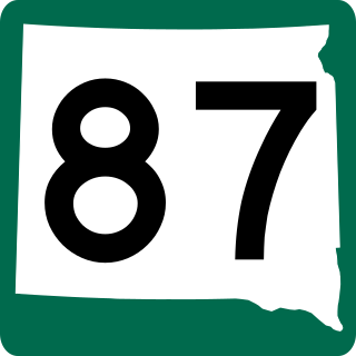
South Dakota Highway 87 (SD 87) is a 37.894-mile-long (60.984 km) state highway in the southwestern part of the U.S. state of South Dakota. It travels through the Black Hills region. The highway's southern terminus is at an intersection with U.S. Route 385 (US 385), about 6 miles (9.7 km) southeast of Pringle, within the southwestern part of Wind Cave National Park. Its northern terminus is at an intersection with US 16/US 385 about 3 miles (4.8 km) south-southwest of Hill City, within the east-central part of the Black Hills National Forest.
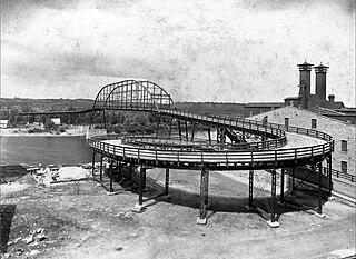
A spiral bridge, loop bridge, helix bridge, or pigtail bridge is a road bridge which loops over its own road, allowing the road to climb rapidly. This is useful in steep terrain, or where the approach road to a bridge would terminate too far from the bridge's end. Despite its name, the typical shape of a spiral bridge forms a helix, not a spiral.

South Dakota Highway 36 is an east–west state route located in southwest South Dakota. It begins at the junction of U.S. Route 16A on the eastern edge of Custer State Park, and ends at South Dakota Highway 79 just south of Hermosa. It is slightly over nine miles (14 km) in length.

Interstate 90 (I-90) in the US state of South Dakota traverses east–west through the southern half of the state.

South Dakota Highway 244 (SD 244) is a short state highway located entirely within Pennington County, South Dakota which provides access to Mount Rushmore. Highway 244 runs generally east–west between its eastern terminus at US 16A near Keystone and its western terminus at US 16/US 385 south of Hill City. The entire route is part of the Peter Norbeck Scenic Byway. SD 244 does not connect to its parent route.
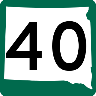
South Dakota Highway 40 (SD 40) is a state highway in southwestern part of the US state of South Dakota. The highway is just over 37 miles (60 km) long and runs from U.S. Route 16A (US 16A) in Keystone to Bureau of Indian Affairs Highway 41 (BIA 41) in Red Shirt. The highway runs near Mount Rushmore National Memorial in Keystone, and its eastern terminus is on the Pine Ridge Indian Reservation near the edge of Badlands National Park.

The Peter Norbeck Scenic Byway is a National Scenic Byway in the Black Hills National Forest in the southwestern part of the U.S. state of South Dakota. It is a loop which is composed of portions of U.S. Route 16A (US 16A), South Dakota Highway 244 (SD 244), SD 87, and SD 89. Parts of the byway enter Black Hills National Forest, Custer State Park, and the Mount Rushmore National Memorial; the byway also travels within five miles of the Crazy Horse Memorial. The byway is named after Peter Norbeck, who served as governor of and senator for South Dakota.
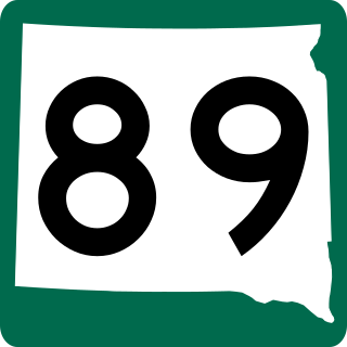
South Dakota Highway 89 (SD 89) is a 34.5-mile (55.5 km) state highway in Fall River and Custer counties in South Dakota, United States, that travels from U.S. Route 18 (US 18) near Minnekahta to SD 87 in Custer State Park. SD 89 is concurrent with US 385 from Pringle to Custer. The portion of the highway from Custer to SD 87 is part of the Peter Norbeck Scenic Byway.
Bismuth is a ghost town in the Black Hills of Custer County, South Dakota, United States.
At least 15 special routes of U.S. Route 16 (US 16) have existed, including four in Michigan.
U.S. Highway 16 (US 16) is a 69-mile-long (111 km) east–west United States Numbered Highway in the western part of the state of South Dakota. It travels between Yellowstone National Park near Newcastle, Wyoming and Interstate 90 (I-90) in Rapid City.


