Related Research Articles
Interstate 25 (I-25) is a major Interstate Highway in the western United States. It is primarily a north–south highway, serving as the main route through New Mexico, Colorado, and Wyoming. I-25 stretches from I-10 at Las Cruces, New Mexico, to I-90 in Buffalo, Wyoming. It passes through or near Albuquerque, New Mexico; Colorado Springs, Colorado; Denver, Colorado; and Cheyenne, Wyoming. The I-25 corridor is mainly rural, especially in Wyoming, excluding the Albuquerque, Pueblo, Colorado Springs, and Denver metropolitan areas.
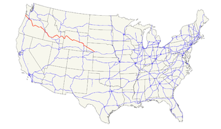
U.S. Route 26 is an east–west United States highway that started in Ogallala, Nebraska. Later, it was subsequently extended to the West Coast in Oregon. When the U.S. highway system was first defined, it was limited to Nebraska and Wyoming; by the 1950s, it continued into Idaho and Oregon. The highway's eastern terminus is in Ogallala, Nebraska at an intersection with Interstate 80. Its western terminus is south of Seaside, Oregon at an intersection with U.S. Route 101. Prior to 2004, the route's last 20 miles (32 km) were co-signed with U.S. Route 101 from the highways' junction south of Seaside north to Astoria where its intersection with U.S. Route 30 was also U.S. 30's western terminus. Long segments of the highway follow the historic Oregon Trail. At its peak, immediately before the establishment of the interstate highway system, US 26 was 1,557 miles (2506 km) in length, and terminated in Astoria, Oregon.
U.S. Route 18 is an east–west U.S. highway in the Midwestern United States. The western terminus is in Orin, Wyoming at an interchange with Interstate 25. Its eastern terminus is in downtown Milwaukee, Wisconsin. However, US 18 runs concurrent with other U.S. routes from its western terminus to Mule Creek Junction, Wyoming. US 18 is one of the original United States highways of 1926. The US 18 designation was originally proposed for a road in Michigan from Grand Haven east to Detroit. This roadway was eventually designated as U.S. Route 16.
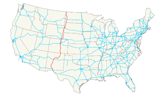
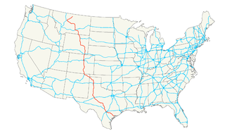
U.S. Route 85 (US 85) is a 1,479-mile-long (2,380 km) north–south United States Highway that travels in the Mountain and Northern Plains states of the United States. The southern terminus of the highway is at the Mexican border in El Paso, Texas, connecting with Mexican Federal Highway 45. The northern terminus is at the Canadian border in Fortuna, North Dakota, where the route continues north as Saskatchewan Highway 35. The highway route is part of the CanAm Highway. Sections of US 85 are designated as the Theodore Roosevelt Expressway.
U.S. Highway 87 is a north–south United States highway that runs for 1,998 miles (3,215 km) from northern Montana to southern Texas. Most of the portion from Billings, Montana to Raton, New Mexico is co-signed along Interstates 90 and 25. It is also co-signed along the majority of Interstate 27 in Texas. As of 2004, the highway's northern terminus is in Havre, Montana, at U.S. Highway 2. Its southern terminus is in Port Lavaca, Texas.
Interstate 180 (I-180) is a one-mile-long (2 km) connector in the U.S. state of Wyoming between I-80 and downtown Cheyenne, Wyoming.
Four Corners is a place in Weston County, Wyoming, United States. It is located in northeastern Wyoming near the Bear Lodge Mountains, part of the Black Hills, at the intersection of U.S. Route 85 and Wyoming Highway 585. It is located north of Newcastle, southeast of Sundance, Wyoming, and southwest of Lead, South Dakota. Originally a stage station on the famous stagecoach road Cheyenne Black Hills Stage Route connecting Cheyenne and the Union Pacific Railroad with the gold fields of Deadwood, it is today the site of a small store, bed-and-breakfast ranches, vacation homes, and tourist camps. Camp Mallo is nearby.
Three Forks is an unincorporated community in Pennington County, South Dakota, United States. It lies at the intersection of U.S. Routes 16 and 385, just north of Hill City along Spring Creek. A small general store featuring fuel is open year-round; other businesses are open seasonally, including a campground, a motel, a miniature golf-course, and an ice-cream stand. The campground is the site of an annual Octoberfest event, and the area is heavily patronized during the Sturgis Motorcycle Rally in August of each year. In recent years, considerable residential development of the immediate area has swollen its population.

Keystone Wye is an interchange of U.S. Route 16 (US 16) and US 16A located in the Black Hills of South Dakota, featuring two unique structural glued laminated timber bridges. The Keystone Wye is a three-level Directional T interchange for the two divided highways, constructed in 1967-1968 as part of a project by the South Dakota Department of Transportation (SDDOT) to convert US 16 to a four-lane highway between Rapid City and Keystone. It was designed by Clyde Jundt and Kenneth C. Wilson.
Interstate 25 (I-25) is a part of the Interstate Highway System that runs from Las Cruces, New Mexico, to Buffalo, Wyoming. In Wyoming, the Interstate Highway runs 300.530 miles (483.656 km) from the Colorado state line near Cheyenne north to its national terminus at I-90 near Buffalo. I-25 connects Wyoming's largest city and capital, Cheyenne, with its second largest city, Casper, and the smaller communities of Wheatland, Douglas, and Buffalo. The highway also connects those cities with Denver and Billings via I-90. I-25 runs concurrently with U.S. Route 87 (US 87) for almost its entire course in Wyoming. The highway also has extensive concurrencies with US 20 and US 26 along its east–west segment through the North Platte River valley. The Interstate has business loops through Cheyenne, Chugwater, Wheatland, Douglas, Glenrock, Casper, and Buffalo.
Wyoming Highway 219, also known as Yellowstone Road, is a 5.48-mile (8.82 km) north–south state highway in central Laramie County, Wyoming, United States, that forms an eastern loop off of U.S. Route 85 (US 85).
Wyoming Highway 224 is a short 0.12-mile-long (0.19 km) unsigned Wyoming State Road for the Wyoming Department of Transportation (WYDOT) Headquarters and the central Wyoming Department of Fish & Game offices, located in Cheyenne.
Wyoming Highway 211 is a 43.88-mile-long (70.62 km) Wyoming State Road known as Horse Creek Road within Laramie County, and as Iron Mountain Road in Platte County.
In the U.S. state of Wyoming, U.S. Highway 14 runs east to west across the northern part of the state. The road connects South Dakota on the east with Yellowstone National Park on the west. It is mostly a two lane surface road except for several sections that it shares with Interstate 90.
Wyoming Highway 387 (WYO 387) is a 57.81-mile-long (93.04 km) state road that travels from extreme northeast Natrona County, Wyoming through extreme southeast Johnson County, Wyoming and into southwest Campbell County, Wyoming.
Wyoming Highway 59 is a 171.72-mile-long (276.36 km) north–south state highway that runs from Douglas to the Montana–Wyoming State Line, where the roadway continues as Montana Highway 59.

Lusk is a high-plains town in the eastern part of the state of Wyoming. The town is the seat of Niobrara County. The town was founded in July 1886, by Frank S. Lusk, a renowned Wyoming rancher, partner in the Western Live Stock Company, and stockholder in the Wyoming Central Railway. Cattle ranching remains the primary industry in the town of Lusk.
Maverick Junction, South Dakota, United States, is an unincorporated community and census-designated place (CDP) located in Fall River County at the intersection of South Dakota Highway 79 and US Highways 18 and 385, approximately five miles southeast of Hot Springs. The population was 46 at the 2020 census.
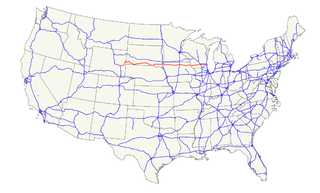
U.S. Route 385 (US 385) is a part of the United States Numbered Highway System that travels from Big Bend National Park in Texas to US 85 in Deadwood, South Dakota. Within the state of Nebraska, the highway is known as the Gold Rush Byway, one of nine scenic byways across the state. The highway follows along the old Sidney-Black Hills trail which played a crucial role during the Black Hills Gold Rush in the late 1870s. It served as the primary route to transport gold and mining gear between Sidney, Nebraska and the Black Hills to the north. Today, the highway enters Nebraska in the southeastern portion of the Nebraska Panhandle on the state line with Colorado northeast of Julesburg and continues in a northerly direction to the South Dakota state line north of Chadron.
References
- ↑ "Wyoming @ AARoads - U.S. Highway 85". www.aaroads.com. Retrieved 2021-09-26.
- ↑ "Wyoming @ AARoads - U.S. Highway 18". www.aaroads.com. Retrieved 2021-09-26.
- ↑ "Mule Creek Junction: A Tale of Toilet Technology". Plumbing and Mechanical Engineer. May 5, 2005. Retrieved 2021-09-26.
- ↑ Hasselstrom, Linda (May 10, 1999). "When you're alone on the open road". High Country News. Retrieved 2021-09-26.
- ↑ "Deadwood Stage Nears Mule Creek Junction". Casper Star-Tribune . May 20, 1964. p. 2. Retrieved October 1, 2021– via Newspapers.com.
- ↑ Newsom, Jim (July 31, 1985). "Mule Creek Junction solar rest stop is no mistake, highway officials say". Casper Star-Tribune . p. 20. Retrieved October 1, 2021– via Newspapers.com.
- ↑ "Mule Creek Junction burns". Casper Star-Tribune . March 13, 1999. p. 11. Retrieved October 1, 2021– via Newspapers.com.
- Archives, Wyoming Department of Transportation
- Registrar of Deeds, Niobrara County (Lusk, Wyoming)
Coordinates: 43°22′43.67″N104°13′21″W / 43.3787972°N 104.22250°W
Municipalities and communities of Niobrara County, Wyoming, United States | ||
|---|---|---|
| Towns |  | |
| CDP | ||
| Unincorporated communities | ||